Mare Crisium
|
Mare Crisium | |
| Coordinates | 17°00′N 59°06′E / 17.0°N 59.1°ECoordinates: 17°00′N 59°06′E / 17.0°N 59.1°E |
|---|---|
| Diameter | 555 km (345 mi)[1] |
| Eponym | Sea of Crises |

Mare Crisium (the "Sea of Crises") is a lunar mare located in the Moon's Crisium basin, just northeast of Mare Tranquillitatis. The basin is of the Pre-Imbrian period, 4.55 to 3.85 billion years ago.
Characteristics
Mare Crisium is 555 km (345 mi) in diameter,[1] and 176,000 square kilometres (68,000 sq mi) in area. It has a very flat floor, with a ring of wrinkle ridges (dorsa) toward its outer boundaries. These are Dorsa Tetyaev, Dorsum Oppel, Dorsum Termier, and Dorsum Harker. The cape-like feature protruding into the southeast of the mare is Promontorium Agarum. On the western rim of the mare is the palimpsest Yerkes, and Lick to the southeast is similar. The crater Picard is located just to the east of Yerkes, and northwest of Picard are the craters Peirce and Swift. The ray system of the crater Proclus overlie the northwestern mare. Mare Anguis can be seen northeast of Mare Crisium.[2]
A mass concentration (mascon), or gravitational high, was identified in the center of Mare Crisium from Doppler tracking of the five Lunar Orbiter spacecraft in 1968.[3] The mascon was confirmed and mapped at higher resolution with later orbiters such as Lunar Prospector and GRAIL.
 Topographic map
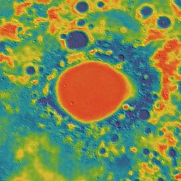 Gravity map based on GRAIL
Names
Like most of the other maria on the Moon, Mare Crisium was named by Giovanni Riccioli, whose 1651 nomenclature system has become standardized.[4]
By the 17th century, Mare Crisium had acquired the name 'Caspian Sea', being labelled as such by Thomas Harriot, Pierre Gassendi and Michael Van Langren. Ewen A. Whitaker speculates that it received this name because it occupies roughly the same position on the Moon's face as does the Caspian Sea on Earth, with respect to maps of Europe, North Africa and the Middle East.[5] The English astronomer William Gilbert's map of c.1600 calls it 'Brittania' after Britain.[5]
Observation and exploration
Mare Crisium is just visible from Earth with the naked eye as a small dark spot on the edge of the Moon's face.
It is the site of the crash-landing of Soviet Luna 15 probe in 1969. A soil sample from Mare Crisium was successfully brought to Earth on 22 August 1976 by the Soviet lunar mission Luna 24.
Views
 Lunar Orbiter 4 image
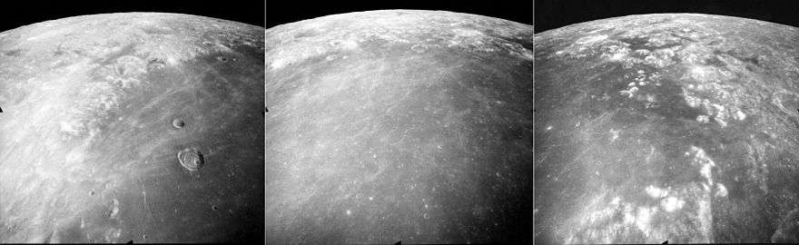 These are three views of northern Mare Crisium on the moon, taken by the mapping camera of the Apollo 17 mission in 1972, facing north-northeast from an average altitude of 118 km on Revolution 27 of the mission. At the right is the east margin of Mare Crisium, with the north tip of Promontorium Agarum visible in the foreground, and Mare Anguis near the central horizon. The crater Eimmart is visible in both the right and central photos as a bright patch (near the top in each). The center photo shows an obvious lack of large craters in the mare indicating a relatively young age of the basalt, and the crater Eimmart C is visible as a ring at the edge of the mare near the top center. The left photo shows the western margin of the mare, with the crater Peirce (larger) and Swift (smaller) in the mare, and the large crater Cleomedes near the central horizon. The rays of the crater Proclus (further to the west, not shown) are prominent in the mare. These photos were taken within minutes of each other. The sun elevation drops from 60 degrees at right to 46 degrees at left as the Command Module America orbited the moon.
In popular culture
- In Robert A. Heinlein's novel The Moon is a Harsh Mistress, Mare Crisium is the site of a lunar colony named Luna City.
- "The Sentinel", the short story from which Arthur C. Clarke developed the film 2001: A Space Odyssey with Stanley Kubrick, takes place on the Mare Crisium.
- In the game "Mass Effect" (2007), the assignment UNC: Rogue VI, operational zone is established in the southern portion of Mare Crisium.
References
- 1 2 "Moon Mare/Maria". Gazetteer of Planetary Nomenclature. USGS Astrogeology. Retrieved 2010-08-20.
- ↑ "Mare Crisium". lunar.arc.nasa.gov. Retrieved October 18, 2007.
- ↑ P. M. Muller, W. L. Sjogren (1968). "Mascons: Lunar Mass Concentrations". Science. 161 (3842): 680–684. doi:10.1126/science.161.3842.680.
- ↑ Ewen A. Whitaker, Mapping and Naming the Moon (Cambridge University Press, 1999), p.61.
- 1 2 Ewen A. Whitaker, Mapping and Naming the Moon (Cambridge University Press, 1999), p.7.
External links
| Wikimedia Commons has media related to Mare Crisium. |