Cripple Creek Historic District
|
Cripple Creek Historic District | |
|
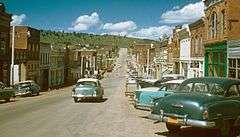
Cripple Creek, 1957 | |
  | |
| Location | Cripple Creek, Colorado |
|---|---|
| Coordinates | 38°45′7″N 105°10′31″W / 38.75194°N 105.17528°WCoordinates: 38°45′7″N 105°10′31″W / 38.75194°N 105.17528°W |
| Built | 1890 |
| NRHP Reference # | 66000939 |
| Significant dates | |
| Added to NRHP | October 15, 1966[1] |
| Designated NHLD | July 4, 1961[2] |
Cripple Creek Historic District [3] is a historic district including Cripple Creek, Colorado, United States and is significant for its gold mining era history.
It was declared a National Historic Landmark in 1961.[2][4]
Many Cripple Creek buildings post-date the gold mining era. The district includes a number of surviving structures, possibly including the following seven:
- The Midland Terminal Depot
- Teller County Courthouse
- The Imperial Hotel
- The Old Homestead
- St. Paul's Catholic Church
- Mansard Roof House, on Warren Avenue
- The El Paso County Hospital, a brick Greek Revival style two story building.
A photograph of each of the seven above is included in the NRHP Inventory documentation.
The boundary of the district is defined by high points around Cripple Creek to include the "natural setting reminiscent of the historic environment. Additionally, it encloses part of the extent of Poverty Gulch where some of the original ore discoveries were made as well as the County Hospital building which is located outside the town limits." [4] (p. 10) It runs from the peak of Mineral Hill (elevation 10,255 feet) southwest to a peak (elevation 9,855 feet), then to northeast corner of Mount Pisgah cemetery, then south along the east border of the cemetery to its southeast corner, then southeast to the peak that is 1600 feet to the northwest of Signal Hill (at elevation 9731), then northeast to the summit of Globe Hill (elevation 10,436), then northwest to peak of Carbonate Hill (elevation 10,335), finally east back to the peak of Mineral Hill.
State Highway 67 is the principal road through the area.
See also
- Cripple Creek & Victor Narrow Gauge Railroad
- National Register of Historic Places listings in Teller County, Colorado
References
- ↑ National Park Service (2007-01-23). "National Register Information System". National Register of Historic Places. National Park Service.
- 1 2 "Cripple Creek Historic District". National Historic Landmark summary listing. National Park Service. Retrieved 2007-10-15.
- ↑ Victor and Cripple Creek History
- 1 2 Joseph Scott Mendinghall (December 9, 1975). "National Register of Historic Places Inventory-Nomination: Cripple Creek Historic District" (pdf). National Park Service. and Accompanying 7 photos, exteriors, from 1975. (950 KB)

| Topics | |
|---|---|
| Lists by states |
|
| Lists by insular areas | |
| Lists by associated states | |
| Other areas | |
| |