Créteil
| Créteil | ||
|---|---|---|
|
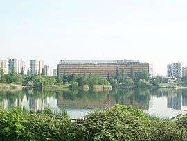
Val-de-Marne prefecture building by the lake | ||
| ||
 Paris and inner ring departments | ||
| Coordinates: 48°47′28″N 2°27′46″E / 48.7911°N 2.4628°ECoordinates: 48°47′28″N 2°27′46″E / 48.7911°N 2.4628°E | ||
| Country | France | |
| Region | Île-de-France | |
| Department | Val-de-Marne | |
| Arrondissement | Créteil | |
| Canton | 2 cantons | |
| Intercommunality | Plaine Centrale du Val-de-Marne | |
| Government | ||
| • Mayor | Laurent Cathala | |
| Area1 | 11.43 km2 (4.41 sq mi) | |
| Population (2006)2 | 90,197 | |
| • Density | 7,900/km2 (20,000/sq mi) | |
| Time zone | CET (UTC+1) | |
| • Summer (DST) | CEST (UTC+2) | |
| INSEE/Postal code | 94028 / 94000 | |
| Elevation |
31–74 m (102–243 ft) (avg. 63 m or 207 ft) | |
|
1 French Land Register data, which excludes lakes, ponds, glaciers > 1 km² (0.386 sq mi or 247 acres) and river estuaries. 2 Population without double counting: residents of multiple communes (e.g., students and military personnel) only counted once. | ||
.svg.png)

Créteil (French pronunciation: [kʁe.tɛj]) is a commune in the southeastern suburbs of Paris, France. It is located 11.5 km (7.1 mi) from the centre of Paris. Créteil is the préfecture (capital) of the Val-de-Marne department as well as the seat of the Arrondissement of Créteil. The city is, moreover, the seat of a Roman Catholic diocese and of one of France's 30 nationwide académies (districts) of the Ministry of National Education.
Name
The name Créteil was recorded for the first time as Cristoïlum in the martyrology written by a monk named Usuard in 865. The name Cristoïlum is made of the Celtic word ialo (meaning "clearing, glade", "place of") suffixed to a pre-Latin radical crist- whose meaning is still unclear. Some believe crist is a Celtic word meaning "ridge", a cognate of Latin crista and modern French crête, in which case the meaning of Cristoïlum would be "clearing on the ridge" or "place on the ridge." A more traditional etymology was that crist referred to Jesus Christ, due to the very ancient presence of Christianity in Créteil and the veneration of Saint Agoard and Saint Aglibert, martyred in Créteil around AD 400.
Geography
Créteil is a city in the south-eastern suburbs of Paris. It is watered by the Marne river which carries out its last loop before the junction with the Seine at the Charenton-le-Pont. The area is an alluvial plain eroded by the action of the Marne and the Seine. Bordering communes include Maisons-Alfort, Saint-Maur-des-Fossés, Bonneuil-sur-Marne, Limeil-Brévannes, Valenton, Choisy-le-Roi and Alfortville.
Climate
The climate in this area has mild differences between highs and lows, and there is adequate rainfall year-round. According to the Köppen Climate Classification system, Créteil has a marine west coast climate, abbreviated "Cfb" on climate maps.[1]
History
Some rare flints from the Palaeolithic age are still being found in modern times in the area. It is, however, a two-ton, Neolithic-era polishing machine that is the prehistoric pride of Créteil. The first documents referring to Créteil are from the Merovingian era, when it was known as Vicus Cristolium' The name comes from the prefix crist and olium. These two terms are thought to be Gallic: "clearing" for olium and "ridge" for crist. The "clearing" of the "ridge" of the Mont-Mesly is on the road connecting Paris and Sens (Trunk Road 19 today). In 1406, the place name "Créteil" makes its appearance after successive deformations from Cristoill (1278), Cristeuil, Cresteul then Creteuil.
During the French Wars of Religion (1567), the Huguenots plundered the church and burned the local charters. New disorders in 1648 forced the evacuation of the inhabitants of Créteil. The end of Louis XIV's reign was marked by a great food shortage throughout the whole of France after a terrible winter in 1709 that resulted in 69 recorded deaths in Créteil. Registers of grievances from the French Revolution in 1789 mention Créteil 15 times.
At the beginning of the 18th century, construction of the first middle-class "Parisian" houses began. In 1814, the east of Créteil was taken by Russian troops. The bridge which spans the Marne between Creteil and Saint-Maur-des-Fossés was inaugurated on 9 April 1841, replacing an ancient ferry.
The Franco-Prussian War of 1870 was particularly cruel for Créteil. The borough was plundered and left in ruins by the Prussians, while the nearby battle of Mont-Mesly on 30 November 1870, left 179 dead. Créteil gave up its pastoral character after World War II. The population subsequently rose from 13,800 in 1954 to 30,654 in 1962.
In 1965, the city became a Préfecture of the new department of the Val-de-Marne.
The lake
Créteil Lake began as a gypsum and gravel quarry. Once the groundwater was reached, forming deep ponds, the quarry was abandoned and allowed to fill with water. The lake area is now a popular recreational site attracting fishermen, boaters, wind surfers, etc...
Demographics
Immigration
| |||||||||||||||||||
Health
As of 1 January 2006, 27 pharmacies, about 60 dentists, about 60 general practitioners, 10 pediatricians, and a half-dozen ophthalmologists and dermatologists constitute the general medical staff of the city.
Health facilities include:
- CHU Henri Mondor, a publicly owned hospital inaugurated on 2 December 1969. Conceived initially for 1,300 beds, its capacity today is 958 beds. It employs more than 3,000 people including more than 2,600 looking after patients. Its expenditure in 2004 was 241M€.
- Centre hospitalier intercommunal de Créteil, inaugurated on 3 November 1937. Capacity of reception of 530 in-patients as against 264 in 1937. The construction of this establishment was decided in 1932 by grouping the communes of the Bonneuil-sur-Marne, Creteil and Joinville-le-Pont within an inter-communal syndicate. Saint-Maur-des-Fossés joined this syndicate later. Originally, a number of the hospital personnel were religious sisters. In 2004, 38,037 hospitalizations were listed, with 2,551 childbirths and 12,838 surgical interventions. ] It employs approximately 2,000 people with about 1,600 of them caring for patients in medical or other capacities.
- Centre de Transfusion sanguine. The Blood Transfusion Centre of Creteil is run by the inter-communal Hospital. This service treats from 600 to 1,000 requests per day.
- Albert Chenevier Hospital. A publicly owned hospital, with a 463-bed capacity. There are 118 beds in the psychiatric ward.
Education
Primary and secondary schools
Public schools:
- 24 preschools[2]
- 24 elementary schools[3]
- Eight junior high schools: Clément Guyard, Victor Hugo, Louis Issaurat, Amédée Laplace, Louis Pasteur, Plaissance, Albert Schweitzer, and Simone-de-Beauvoir[4]
- Four high schools: Lycée Léon Blum, Lycée Édouard Branly, Lycée Gutenberg, and Lycée Antoine de Saint-Exupery[5]
Private schools:
- Ozar Hatorah (includes preschool, elementary school,[6] a junior high school divided into boys' and girls' schools,[4] and a high school divided into boys' and girls' schools[5])
- De Maillé (elementary school,[6] junior high school[4])
- Lycée général et technologique de l'ensemble Sainte-Marie[5]
- Lycée d'enseignement supérieur technique privé SUPTEK[5]
Universities
The city hosts Paris 12 Val de Marne University, officially the Paris-Est Créteil Val-de-Marne University, founded in 1970. Previously known as Université Paris 12 Val de Marne or Université Paris XII, the university serves more than 30,000 students and consists of seven units of formation and research (UFR), namely law, administration, literature, medicine, business & management, educational sciences and technological sciences.
Transport
Créteil is served by four stations on Paris Métro Line 8: Créteil – L'Échat, Créteil – Université, Créteil – Préfecture and the newly opened Pointe du Lac.
Sport
US Créteil-Lusitanos, founded in 1936, is the city's football club. They currently play in Ligue 2 and their home stadium is Stade Dominique Duvauchelle.
Notable people
- Jordan Aboki, basketball player
- Bertrand Amoussou-Guenou, mixed martial artist
- Jacques Barzun, author, historian
- Stephane Caristan, athlete
- Isaia Cordinier, basketball player
- Bruno Coqueran, basketball player
- Mohamed Diamé, footballer
- Herve Ebanda, footballer
- Sylviane Félix, athlete
- Lina Jacques-Sebastien, athlete
- Lahaou Konate, basketball player
- Azrack Mahamat, footballer
- Axel Médéric, figure skater
- Modibo Niakate, basketball player
- Michael Nkololo, footballer
- Fabien Paschal, basketball player
- Marc Raquil, athlete
- Christopher Samba, footballer
- Richard Soumah, footballer
- Sammy Traoré, footballer
International relations

Créteil is twinned with:
|
|
See also
References
- INSEE
- Mayors of Essonne Association (French)
- ↑ Climate Summary for Créteil, France
- ↑ "Écoles maternelles ." Créteil. Retrieved on September 4, 2016.
- ↑ "Écoles élémentaires ." Créteil. Retrieved on September 4, 2016.
- 1 2 3 "Collèges." Créteil. Retrieved on September 4, 2016.
- 1 2 3 4 "Lycées." Créteil. Retrieved on September 4, 2016.
- 1 2 "Écoles maternelles et élémentaires privées ." Créteil. Retrieved on September 4, 2016.
- ↑ "British towns twinned with French towns [via WaybackMachine.com]". Archant Community Media Ltd. Archived from the original on 5 July 2013. Retrieved 2013-07-20.
External links
| Wikimedia Commons has media related to Créteil. |
| Population over 2 million | |
|---|---|
| Population over 100,000 | |
| Population over 75,000 | |
| Population over 50,000 | |
| Population over 25,000 |
|
| Population under 25,000 |
|
|