Cowrock Mountain
| Cowrock Mountain | |
|---|---|
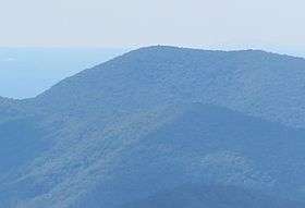 Cowrock Mountain viewed from Brasstown Bald | |
| Highest point | |
| Elevation | 3,852 ft (1,174 m) |
| Coordinates | 34°43′18″N 83°51′24″W / 34.72167°N 83.85667°W |
| Geography | |
| Location | Lumpkin / White counties, Georgia, U.S. |
| Parent range | Blue Ridge Mountains |
| Topo map | USGS Cowrock |
| Climbing | |
| First ascent | unknown |
| Easiest route | Appalachian Trail |
Cowrock Mountain is a mountain that is located in Lumpkin and White counties in Georgia. The mountain forms a north/south ridge. Its northern peak, Cowrock, has an elevation of 3,852 feet (1,174 m) and its southern peak, Cowrock Flat, has an elevation of 3,502 feet (1,067 m). The boundary line between Lumpkin and White counties follows the ridge formed by Cowrock Mountain. The peak called Cowrock is the highest point in Lumpkin County, forms the northeast corner of the county. The Appalachian Trail also crosses Cowrock Mountain. The mountain is located within the Raven Cliffs Wilderness in the Chattahoochee National Forest.
Sources
External links
This article is issued from Wikipedia - version of the 9/15/2015. The text is available under the Creative Commons Attribution/Share Alike but additional terms may apply for the media files.