Coweta, Oklahoma
| Coweta, Oklahoma | |
|---|---|
| City | |
 | |
 Location of Coweta, Oklahoma | |
| Coordinates: 35°57′47″N 95°39′42″W / 35.96306°N 95.66167°WCoordinates: 35°57′47″N 95°39′42″W / 35.96306°N 95.66167°W | |
| Country | United States |
| State | Oklahoma |
| County | Wagoner |
| Area | |
| • Total | 7.7 sq mi (19.9 km2) |
| • Land | 7.6 sq mi (19.6 km2) |
| • Water | 0.1 sq mi (0.3 km2) |
| Elevation | 663 ft (202 m) |
| Population (2010) | |
| • Total | 9,943 |
| • Density | 1,300/sq mi (500/km2) |
| Time zone | Central (CST) (UTC-6) |
| • Summer (DST) | CDT (UTC-5) |
| ZIP code | 74429 |
| Area code(s) | 539/918 |
| FIPS code | 40-17800[1] |
| GNIS feature ID | 1091781[2] |
| Website | City of Coweta |
Coweta is a city in Wagoner County, Oklahoma, United States and is a suburb of Tulsa. As of 2010, the population was 9,943.[3] Part of the Creek Nation in Indian Territory before Oklahoma became a U.S. state, the town was first settled in 1840.[4]
History
Before statehood, when the Five Tribes or Five Civilized Tribes were moved to Oklahoma from the Eastern United States, the area that is now Coweta became part of the Muscogee (Creek) Nation. Coweta was named after a Lower Creek town on the Chattahoochee River in southwestern Georgia and was first settled by Muscogees about 1840. In 1843 Robert Loughridge arrived in the area and established a mission, named "Koweta". Loughridge left Koweta in 1850 to supervise the newly completed Tullahassee Manual Labor School. Koweta closed in 1861.[4]
In 1867 after the Civil War, the Creek Indians adopted a constitution which divided their nation into six districts. Everything northeast of the Arkansas River, including Tulsa, became the Coweta district. The political center of this district was located in a log courthouse on Coweta Creek, about a quarter mile west from the modern day center of the downtown Coweta. The Post Office was established on May 24, 1897, and took its name from Koweta Mission.[5] As a result of negotiations with the Congress appointed Dawes Commission regarding the allotment of tribal lands in 1898, the Creek courts’ jurisdiction was turned over to the Federal government.
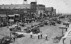
Many notable events occurred in 1903. Along with the arrival of the Missouri-Kansas-Texas Railroad, Coweta’s first newspaper, The Courier, was started, the first school was built, and a telephone line was installed.
Geography
Coweta is located at 35°57′47″N 95°39′42″W / 35.96306°N 95.66167°W (35.963155, -95.661586).[6]
According to the United States Census Bureau, the city has a total area of 7.7 square miles (20 km2), of which, 7.6 square miles (20 km2) of it is land and 0.1 square miles (0.26 km2) of it (1.56%) is water.
Climate
Coweta has a temperate climate of the humid subtropical variety (Köppen Cfa) with a yearly average precipitation of 43.9 inches (1,120 mm) and average snowfall of 1.8 inches (45.7 mm).[7]
Demographics
| Historical population | |||
|---|---|---|---|
| Census | Pop. | %± | |
| 1910 | 1,187 | — | |
| 1920 | 1,318 | 11.0% | |
| 1930 | 1,274 | −3.3% | |
| 1940 | 1,455 | 14.2% | |
| 1950 | 1,601 | 10.0% | |
| 1960 | 1,858 | 16.1% | |
| 1970 | 2,457 | 32.2% | |
| 1980 | 4,554 | 85.3% | |
| 1990 | 6,159 | 35.2% | |
| 2000 | 7,139 | 15.9% | |
| 2010 | 9,943 | 39.3% | |
| Est. 2015 | 9,559 | [8] | −3.9% |
As of the census[1] of 2000, there were 7,139 people, 2,582 households, and 1,988 families residing in the city. The population density was 942.1 people per square mile (363.6/km²). There were 2,827 housing units at an average density of 373.1 per square mile (144.0/km²). The racial makeup of the city was 75.78% White, 4.08% African American, 11.85% Native American, 0.21% Asian, 0.01% Pacific Islander, 1.75% from other races, and 6.32% from two or more races. Hispanic or Latino of any race were 3.80% of the population.
There were 2,582 households out of which 43.0% had children under the age of 18 living with them, 58.5% were married couples living together, 13.9% had a female householder with no husband present, and 23.0% were non-families. 19.9% of all households were made up of individuals and 6.6% had someone living alone who was 65 years of age or older. The average household size was 2.74 and the average family size was 3.14.
In the city the population was spread out with 30.9% under the age of 18, 9.6% from 18 to 24, 31.0% from 25 to 44, 20.0% from 45 to 64, and 8.6% who were 65 years of age or older. The median age was 31 years. For every 100 females there were 95.1 males. For every 100 females age 18 and over, there were 90.5 males.
The median income for a household in the city was $38,255, and the median income for a family was $41,786. Males had a median income of $32,348 versus $21,772 for females. The per capita income for the city was $14,960. About 6.2% of families and 7.4% of the population were below the poverty line, including 7.4% of those under age 18 and 11.1% of those age 65 or over.
Schools
The Coweta Public School District is the 29th largest school district in the state and as of October 2007 the district had 3,161 pre kindergarten through 12th grade students enrolled in 6 different schools, the district is also the largest in Wagoner County.[10]
Media
Coweta has one newspaper, the Coweta American. The paper is published every Wednesday. It is owned by BH Media Group. Coweta has a community website, N2Coweta that provides everyone in the community a free place to discuss local topics, share status updates, blog, list events, participate in discussions, and share photos and videos.[11]
Points of interest
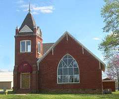
Coweta is home to two sites on the National Register of Historic Places list. The first is the Koweta Mission Site. The mission was added to the NRHP in 1973, today only a cemetery remains. The second historical site located in Coweta is the First Presbyterian Church of Coweta, commonly known as the Mission Bell Museum. The Mission Bell Museum was added to the NRHP in 2003 and is owned and operated by the city of Coweta.
Notable people
- Junior Barnard, (December 17, 1920 - April 15, 1951) guitarist with Bob Wills and His Texas Playboys
- Bill Bright, William R. "Bill" Bright (October 19, 1921 – July 19, 2003), founder of Campus Crusade
- Rick Bryan, (March 20, 1962 - July 25, 2009) American Football defensive lineman for the Oklahoma Sooners and the Atlanta Falcons
- Crooked X, a rock band discovered on the CBS morning TV show, The Early Show
- Louis Oliver (April 9, 1904 – May 10, 1991), Creek poet
References
- 1 2 "American FactFinder". United States Census Bureau. Archived from the original on September 11, 2013. Retrieved 2008-01-31.
- ↑ "US Board on Geographic Names". United States Geological Survey. 2007-10-25. Retrieved 2008-01-31.
- ↑ "Profile of General Population and Housing Characteristics: 2010". U.S. Census Bureau. Archived from the original on March 5, 2014. Retrieved 2011-07-17.
- 1 2 Walters, Norma. Encyclopedia of Oklahoma History and Culture. "Coweta."
- ↑ "How places got their names". Oklahoma Historical Society. Retrieved 2008-01-18.
- ↑ "US Gazetteer files: 2010, 2000, and 1990". United States Census Bureau. 2011-02-12. Retrieved 2011-04-23.
- ↑ Coweta, Oklahoma, Weatherbase.com. (accessed October 13, 2013)
- ↑ "Annual Estimates of the Resident Population for Incorporated Places: April 1, 2010 to July 1, 2015". Retrieved July 2, 2016.
- ↑ "Census of Population and Housing". Census.gov. Archived from the original on May 11, 2015. Retrieved June 4, 2015.
- ↑ "Public Schools Database". Oklahoma Department of Education. Archived from the original on September 30, 2006. Retrieved 2008-04-24.
- ↑ "N2Coweta". Retrieved 2011-10-25.
External links
| Counties | 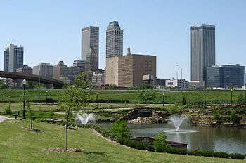 | |
|---|---|---|
| Principal city | ||
| Cities over 20k | ||
| Cities 10k-20k | ||
| Cities 5k-10k | ||
| Cities and towns 1k-5k | ||
Municipalities and communities of Wagoner County, Oklahoma, United States | ||
|---|---|---|
| Cities | 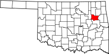 | |
| Towns | ||
| Unincorporated communities |
| |
| Footnotes | ‡This populated place also has portions in an adjacent county or counties | |
| Coweta | ||
|---|---|---|
| Okay |
| |
| Porter |
| |
| Redbird |
| |
| Tullahassee | ||
| Wagoner |
| |