Courtland, Kansas
| Courtland, Kansas | |
|---|---|
| City | |
|
Courtland Mural (2012) | |
 Location within Republic County and Kansas | |
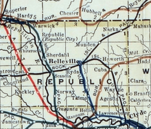
 KDOT map of Republic County (legend) | |
| Coordinates: 39°46′58″N 97°53′49″W / 39.78278°N 97.89694°WCoordinates: 39°46′58″N 97°53′49″W / 39.78278°N 97.89694°W | |
| Country | United States |
| State | Kansas |
| County | Republic |
| Area[1] | |
| • Total | 0.27 sq mi (0.70 km2) |
| • Land | 0.27 sq mi (0.70 km2) |
| • Water | 0 sq mi (0 km2) |
| Elevation | 1,496 ft (456 m) |
| Population (2010)[2] | |
| • Total | 285 |
| • Estimate (2012[3]) | 275 |
| • Density | 1,100/sq mi (410/km2) |
| Time zone | Central (CST) (UTC-6) |
| • Summer (DST) | CDT (UTC-5) |
| ZIP code | 66939 |
| Area code(s) | 785 |
| FIPS code | 20-16025 [4] |
| GNIS feature ID | 0472819 [5] |
| Website | courtlandks.com |

Courtland is a city in Republic County, Kansas, United States. As of the 2010 census, the city population was 285.[6]
History
The first settlement was made at Courtland in 1885.[7] A post office was opened in Prospect (an extinct town) in 1878, but it was moved to Courtland in 1888.[8] The community was named after Cortland, New York.[9]
In 1887, Atchison, Topeka and Santa Fe Railway built a branch line from Neva (3 miles west of Strong City) through Courtland to Superior, Nebraska. In 1996, the Atchison, Topeka and Santa Fe Railway merged with Burlington Northern Railroad and renamed to the current BNSF Railway. Most locals still refer to this railroad as the "Santa Fe".
Courland was incorporated as a city in 1892.[10]
Geography
Courtland is located at 39°46′58″N 97°53′49″W / 39.78278°N 97.89694°W (39.782803, -97.897054).[11] According to the United States Census Bureau, the city has a total area of 0.27 square miles (0.70 km2), all of it land.[1]
Demographics
| Historical population | |||
|---|---|---|---|
| Census | Pop. | %± | |
| 1890 | 267 | — | |
| 1900 | 286 | 7.1% | |
| 1910 | 454 | 58.7% | |
| 1920 | 411 | −9.5% | |
| 1930 | 430 | 4.6% | |
| 1940 | 383 | −10.9% | |
| 1950 | 367 | −4.2% | |
| 1960 | 384 | 4.6% | |
| 1970 | 403 | 4.9% | |
| 1980 | 377 | −6.5% | |
| 1990 | 343 | −9.0% | |
| 2000 | 334 | −2.6% | |
| 2010 | 285 | −14.7% | |
| Est. 2015 | 270 | [12] | −5.3% |
| U.S. Decennial Census | |||
2010 census
As of the census[2] of 2010, there were 285 people, 137 households, and 82 families residing in the city. The population density was 1,055.6 inhabitants per square mile (407.6/km2). There were 161 housing units at an average density of 596.3 per square mile (230.2/km2). The racial makeup of the city was 98.9% White, 0.7% African American, and 0.4% Asian. Hispanic or Latino of any race were 0.4% of the population.
There were 137 households of which 26.3% had children under the age of 18 living with them, 46.0% were married couples living together, 7.3% had a female householder with no husband present, 6.6% had a male householder with no wife present, and 40.1% were non-families. 34.3% of all households were made up of individuals and 14.6% had someone living alone who was 65 years of age or older. The average household size was 2.08 and the average family size was 2.66.
The median age in the city was 46.1 years. 22.1% of residents were under the age of 18; 6% were between the ages of 18 and 24; 19.7% were from 25 to 44; 29.8% were from 45 to 64; and 22.5% were 65 years of age or older. The gender makeup of the city was 52.6% male and 47.4% female.
2000 census
As of the census[4] of 2000, there were 334 people, 149 households, and 96 families residing in the city. The population density was 1,243.5 people per square mile (477.6/km²). There were 174 housing units at an average density of 647.8 per square mile (248.8/km²). The racial makeup of the city was 98.80% White, 0.30% African American, 0.30% Native American, 0.60% from other races. Hispanic or Latino of any race were 3.89% of the population.
There were 149 households out of which 28.9% had children under the age of 18 living with them, 57.0% were married couples living together, 3.4% had a female householder with no husband present, and 34.9% were non-families. 32.2% of all households were made up of individuals and 21.5% had someone living alone who was 65 years of age or older. The average household size was 2.24 and the average family size was 2.84.
In the city the population was spread out with 25.1% under the age of 18, 3.9% from 18 to 24, 18.3% from 25 to 44, 23.7% from 45 to 64, and 29.0% who were 65 years of age or older. The median age was 47 years. For every 100 females there were 100.0 males. For every 100 females age 18 and over, there were 98.4 males.
The median income for a household in the city was $27,188, and the median income for a family was $37,778. Males had a median income of $26,667 versus $13,500 for females. The per capita income for the city was $14,543. About 6.3% of families and 11.3% of the population were below the poverty line, including 12.8% of those under age 18 and 19.1% of those age 65 or over.
References
- 1 2 "US Gazetteer files 2010". United States Census Bureau. Archived from the original on 2012-07-14. Retrieved 2012-07-06.
- 1 2 "American FactFinder". United States Census Bureau. Retrieved 2012-07-06.
- ↑ "Population Estimates". United States Census Bureau. Archived from the original on 2013-06-17. Retrieved 2013-05-29.
- 1 2 "American FactFinder". United States Census Bureau. Archived from the original on 2013-09-11. Retrieved 2008-01-31.
- ↑ "US Board on Geographic Names". United States Geological Survey. 2007-10-25. Retrieved 2008-01-31.
- ↑ "2010 City Population and Housing Occupancy Status". U.S. Census Bureau. Archived from the original on July 21, 2011. Retrieved October 18, 2011.
- ↑ Blackmar, Frank Wilson (1912). Kansas: A Cyclopedia of State History, Embracing Events, Institutions, Industries, Counties, Cities, Towns, Prominent Persons, Etc. Standard Publishing Company. p. 461.
- ↑ "Kansas Post Offices, 1828-1961". Kansas Historical Society. Archived from the original on October 9, 2013. Retrieved 21 June 2014.
- ↑ "Profile for Courtland, Kansas". ePodunk. Retrieved 21 June 2014.
- ↑ Savage, Isaac O. (1901). A History of Republic County, Kansas. Jones & Chubbic. p. 188.
- ↑ "US Gazetteer files: 2010, 2000, and 1990". United States Census Bureau. 2011-02-12. Retrieved 2011-04-23.
- ↑ "Annual Estimates of the Resident Population for Incorporated Places: April 1, 2010 to July 1, 2015". Retrieved July 2, 2016.
External links
| Wikimedia Commons has media related to Courtland, Kansas. |
- City
- Schools
- USD 426, local school district
- Newspaper
- The Courtland Journal local newspaper
- Photos of a tour of the area including downtown Courtland
- Maps
- Courtland City Map, KDOT
Municipalities and communities of Republic County, Kansas, United States | ||
|---|---|---|
| Cities | 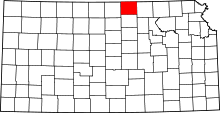 | |
| Townships | ||
| Unincorporated communities | ||