Court (District Electoral Area)
| Court District Electoral Area |
|
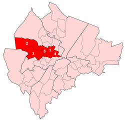 Map showing Castle wards within Belfast |
|
| Population | (2008 Estimate) |
|---|---|
| District | Belfast City Council |
| County | County Antrim |
| Country | Northern Ireland |
| Sovereign state | United Kingdom |
| EU Parliament | Northern Ireland |
| UK Parliament | Belfast North Belfast West |
| NI Assembly | Belfast North Belfast West |
|
|
Court is one of the ten district electoral areas (DEA) in Belfast, Northern Ireland. Located in the north and west of the city, the district elects six members to Belfast City Council and contains the wards of Ballygomartin, Clonard, Falls, Forth River, Shankill, and Woodvale. Court is split between the Belfast North and Belfast West constituencies for the Northern Ireland Assembly and UK Parliament.
History
The DEA was created for the 1985 local elections. It initially contained six wards, three of which came from the abolished Area E, with the remainder from Area G. From the 1993 to 2011 local elections, it contained five wards, namely Crumlin, Glencairn, Highfield, Shankill and Woodvale, following the abolition of the Saint Anne's ward. For the 2014 local elections, the Crumlin ward was abolished, the Glencairn ward was replaced by Forth River ward and the Highfield ward was replaced by Ballygomartin ward. These four wards were joined by the Falls and Clonard wards, which had previously been part of the abolished Lower Falls District Electoral Area.
Wards
| Map | Ward | Population (2011 Census) | Catholic | Protestant | Other | No Religion | Area | Density | NI Assembly | UK Parliament | Ref | ||
|---|---|---|---|---|---|---|---|---|---|---|---|---|---|
| 1 | Crumlin | 4,582 | 11.3% | 82.3% | 0.6% | 5.9% | 0.83 km2 | 5,520/km2 | Belfast North | Belfast North | [1] | ||
| 2 | Glencairn | 3,749 | 17.5% | 75.5% | 0.9% | 6.1% | 4.1 km2 | 914/km2 | Belfast West | Belfast West | [2] | ||
| 3 | Highfield | 5,651 | 9.5% | 82.6% | 0.9% | 7% | 2.69 km2 | 2,101/km2 | Belfast West | Belfast West | [3] | ||
| 4 | Shankill | 3,816 | 7.9% | 84.5% | 0.7% | 6.9% | 0.93 km2 | 4,103/km2 | Belfast West | Belfast West | [4] | ||
| 5 | Woodvale | 4,088 | 6% | 87% | 0.6% | 6.4% | 0.57 km2 | 7,172/km2 | Belfast North | Belfast North | [5] | ||
| Court | 21,886 | 10.3% | 82.5% | 0.7% | 6.5% | 9.12 km2 | 2,400/km2 | Belfast North (2) Belfast West (3) | Belfast North (2) Belfast West (3) | ||||
Councillors
| Election | Councillor (Party) |
Councillor (Party) |
Councillor (Party) |
Councillor (Party) |
Councillor (Party) |
Councillor (Party) | ||||||
|---|---|---|---|---|---|---|---|---|---|---|---|---|
| 2014 | Brian Kingston (DUP) |
Billy Hutchinson (PUP) |
Mary McConville (Sinn Féin) |
Jolene Bunting (TUV) |
Frank McCoubrey (DUP) |
Jim McVeigh (Sinn Féin) | ||||||
| 2011 | Hugh Smyth (PUP) |
Naomi Thompson (DUP) |
William Humphrey (DUP) |
Frank McCoubrey (Independent) |
Reduced to 5 seats from 1993 to 2011 | |||||||
| 2005 | Diane Dodds (DUP) |
Elaine McMillen (DUP) | ||||||||||
| 2001 | Eric Smyth (DUP) |
Chris McGimpsey (UUP) | ||||||||||
| 1997 | Fred Cobain (UUP) |
Frank McCoubrey (UDP) | ||||||||||
| 1993 | Joe Coggle (Independent Unionist) | |||||||||||
| 1989 | Herbert Ditty (UUP) |
Elizabeth Seawright (Independent Unionist) | ||||||||||
| 1985 | Ted Ashby (DUP) |
George Seawright (Independent Unionist) | ||||||||||
2011 Elections
| Belfast City Council elections, 2011[6] | |||
|---|---|---|---|
| Party | Candidate | 1st Pref | |
| DUP | William Humphrey | 2,643 | |
| DUP | Brian Kingston | 1,371 | |
| Independent | Frank McCoubrey | 754 | |
| PUP | Hugh Smyth | 640 | |
| UUP | Bobby McConnell | 395 | |
| DUP | Naomi Thompson | 237 | |
| Independent | Raymond McCord | 199 | |
| Sinn Féin | Karol McKee | 184 | |
| SDLP | Conor McNeill | 99 | |
| Alliance | Mark Long | 78 | |
| Turnout | 6,600 | ||
| No change | |||
See also
- Shankill Road
- Belfast City Council
- Electoral wards of Belfast
- Local government in Northern Ireland
- Members of Belfast City Council
References
- ↑ "Ward Information for Crumlin (Belfast) ward 95GG19". NISRA. Retrieved 22 December 2013.
- ↑ "Ward Information for Glencairn ward 95GG26". NISRA. Retrieved 22 December 2013.
- ↑ "Ward Information for Highfield ward 95GG28". NISRA. Retrieved 22 December 2013.
- ↑ "Ward Information for Shankill ward 95GG40". NISRA. Retrieved 22 December 2013.
- ↑ "Ward Information for Woodvale ward 95GG51". NISRA. Retrieved 22 December 2013.
- ↑ Elections 2011: Court, Belfast City Council
 |
Oldpark | | ||
| Antrim Borough Council | |
Castle | ||
| ||||
| | ||||
| Lower Falls Upper Falls |
| General |  | |
|---|---|---|
| People | ||
| District Electoral Areas | ||
| Amenities | ||
| Parks and gardens | ||
| Cemeteries | ||
| Elections | ||
| ||