Cotabato (historical province)
| Province of Cotabato | |||||
| Former province of the Philippines | |||||
| |||||
 | |||||
| Capital |
| ||||
| History | |||||
| • | Established | 23 July 1914 | |||
| • | Disestablished | 22 November 1973 | |||
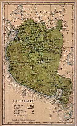
| Area | 22,967.91 km2 (8,868 sq mi) | ||||
| Political subdivisions |
| ||||
| Today part of | |||||
Cotabato, also known as the Empire Province of Cotabato, was a historical province of the Philippines established in 1914 that existed until its dissolution in 1973. The province's capital from 1920-1967 was Cotabato City while Pagalungan became its capital from 1967-1973.
Originally a district of the former Moro Province, on September 1, 1914, the defunct Department of Mindanao and Sulu provided with autonomous government through Act No. 2408 enacted on July 23, 1914, converted the district into a province along with other former Moro Province districts:[3] Davao, Lanao, Sulu, Zamboanga, and its former sub-province Bukidnon. Davao, Lanao and Zamboanga were then later split and partitioned into different current provinces while Sulu and Bukidnon remain what it is today.
The empire province was one of the largest provinces of the Philippines, with an area of 2,296,791 hectares (22,967.91 km2).[3] It was dissolved on 1973, comprising what are now the provinces of Cotabato, South Cotabato, Sarangani, Sultan Kudarat and Maguindanao.
History
Upon its separation from the Department of Mindanao and Sulu, Cotabato comprised the municipalities of Cotabato (the provincial capital), Dulawan, and Midsayap, and the following municipal districts:[4]
- Awang
- Balatikan
- Balut
- Banisilan
- Barira
- Buayan
- Bugasan
- Buldun
- Buluan
- Carmen
- [Daguma]
- Dinaig
- [Dulawan]
- Gambar
- Glan
- [Isulan]
- Kabakan
- Kalanganan
- Kiamba
- Kidapawan
- Kitubud
- Kling
- Koronadal
- Lebak
- [Libuangan]
- Liguasan
- [Maganui]
- Nuling
- Parang
- Pikit-Pagalungan
- [Reina Regente]
- Salaman
- Sebu
- Silik
- Subpangan
- [Talayan]
- Tumbau
On June 18, 1966, South Cotabato was separated from the province through Republic Act No. 4849.[2]

Dissolution
On November 22, 1973, the remaining territories of the Empire Province of Cotabato was divided into North Cotabato, Maguindanao and Sultan Kudarat through Presidential Decree No. 341.[1]
On March 7, 1984, North Cotabato was renamed to simply "Cotabato" through Batas Pambansa Blg. 660.[5]
On March 16, 1992, the province of Sarangani was formed out of South Cotabato.[6]
See also
References
- 1 2 "Presidential Decree No. 341 - Creating the Provinces of North Cotabato, Maguindanao and Sultan Kudarat". Official Gazette of the Republic of the Philippines. Malacañang, Manila, Philippines. 22 November 1973. Retrieved 27 April 2016.
- 1 2 "Republic Act No. 4849 - An Act Creating the Province of South Cotabato". Chan Robles Virtual Law Library. 18 July 1966. Retrieved 27 April 2016.
- 1 2 "Our Province". Province of Cotabato. Retrieved 27 April 2016.
The total land area of the original Cotabato before its division was 2,296,791 hectares or about one thirteenth of the whole country which has an area of about 30 million hectares. So big was the original province that its area was about the size of the central plain of Luzon and bigger than six states in the United States, including the states of Massachusetts, Connecticut and Rhode Island. The total land area of the Hawaiian Islands (now a U.S. state) is only about three-fourths that of Cotabato.
- ↑ "Act No. 2711; An Act Amending the Administrative Code". Official Gazette of the Republic of the Philippines. 10 March 1917. Retrieved 27 April 2016.
The Province of Cotabato lies east and south of the Province of Lanao, south of the Province of Bukidnon and west of the Province of Davao and contains the following municipalities: Cotabato (the capital of the province), Dulawan, and Midsayap. The province also contains the following municipal districts: Awang, Balatikan, Balut, Banisilan, Barira, Buayan, Bugasan, Buldun, Buluan, Carmen,[Daguma], Dinaig,[Dulawan,] Gambar, Glan,[Isulan], Kabakan, Kalanganan, Kiamba, Kidapawan, Kitubud, Kling, Koronadal, Lebak,[Libuangan], Liguasan,[Maganui], Nuling, Parang, Pikit-Pagalungan,[Reina Regente], Salaman, Sebu, Silik, Subpangan,[Talayan] and Tumbau.
- ↑ "Batas Pambansa Blg. 660 - An Act Changing the Name of the Province of North Cotabato to Cotabato". Chan Robles Virtual Law Library. 7 March 1984. Retrieved 27 April 2016.
- ↑ "Republic Act No. 7228 - An Act Creating the Province of Sarangani". Chan Robles Virtual Law Library. 16 March 1992. Retrieved 27 April 2016.