Corryton, Tennessee
| Corryton | |
|---|---|
| Unincorporated community | |
|
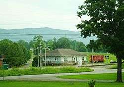
Corryton Branch Library, with House Mountain in the distance | |
 Corryton  Corryton Location within the state of Tennessee | |
| Coordinates: 36°09′13″N 83°46′57″W / 36.15361°N 83.78250°WCoordinates: 36°09′13″N 83°46′57″W / 36.15361°N 83.78250°W | |
| Country | United States |
| State | Tennessee |
| County | Knox |
| Time zone | Eastern (EST) (UTC-5) |
| • Summer (DST) | EDT (UTC-4) |
| ZIP codes | 37721 |
| Area code(s) | 865 |
| FIPS code | 47093 |
| GNIS feature ID | 1281332[1] |
Corryton is an unincorporated community in northeastern Knox County, Tennessee, United States, about 15 miles northeast of Knoxville. The United States Geographic Names System classifies Corryton as a populated place.[1] It is included in the Knoxville, TN Metropolitan Statistical Area. The Corryton Zip Code also encompasses the adjacent community of Gibbs (sometimes known as Harbisons Crossroads).
Corryton is situated near two mountains, House Mountain (the highest point in Knox County)[2] and Clinch Mountain. It includes a grade school, a public library, community center, and several churches including Little Flat Creek Baptist Church (founded in 1797, making it the first Baptist church organized in Knox County), Corryton Church (formerly Corryton Baptist) and Rutherford Memorial United Methodist.
John Sawyers, a Revolutionary War veteran, settled in the vicinity of what is now Corryton in 1785. He subsequently built a small fort along the Emory Road. The community remained primarily agricultural until the construction of the Knoxville, Cumberland Gap and Louisville Railroad through the area in the late 1880s. The rail station that served the community was initially known as "Floyd." In 1887, an entrepreneur named Corryton Woodbury purchased the station and adjacent lands, and laid out lots in hopes of establishing a new town, which he named after himself. The lots failed to sell, however, and the venture was unsuccessful.[3]
Gibbs High School in Corryton has several famous alumni, including country musicians Kenny Chesney, Con Hunley, Phil Leadbetter, and Ashley Monroe.
On April 25, 1983, Thomas Knauff set an FAI world record flying a glider on an out-and-return course of 1,646.68 km (1,023.20 mi), releasing from tow over Williamsport Regional Airport in Pennsylvania, flying south along the Ridge-and-valley Appalachians to take a turn-point photograph of the Little Flat Creek Church in Corryton, then returning for a landing after a 10-hour flight. The photographs were published in National Geographic magazine. This world record stood until 2003 when it was broken in Argentina, but still stands as a U.S. national record.[4]
References
| Wikimedia Commons has media related to Corryton, Tennessee. |
- 1 2 "Corryton, Tennessee". Geographic Names Information System. United States Geological Survey.
- ↑ Tom Dunigan (2013-12-08). "Tennessee county high points". Tnlandforms.us. Retrieved 2016-06-23.
- ↑ Mary Rothrock, The French Broad-Holston Country: A History of Knox County, Tennessee (East Tennessee Historical Society, 1972), pp. 349-350.
- ↑ Gliding World Records ID 5427, Fédération Aéronautique Internationale
Municipalities and communities of Knox County, Tennessee, United States | ||
|---|---|---|
| City | ||
| Town | ||
| CDP | ||
| Other unincorporated communities | ||
| Footnotes | ‡This populated place also has portions in an adjacent county or counties | |
| Principal City |   | |
|---|---|---|
| Other Cities | ||
| Counties | ||