Coronini
| Coronini Pescari Czech: Koronie Hungarian: Lászlóvára, Koronini | |
|---|---|
| Commune | |
|
View over Coronini and the Danube | |
 Location in Caraș-Severin County | |
 Coronini Location in Romania | |
| Coordinates: 44°44′N 21°41′E / 44.733°N 21.683°E | |
| Country |
|
| County | Caraş-Severin County |
| Government | |
| • Mayor | Gheorghe Dăneț (Democratic Liberal Party) |
| Area | |
| • Total | 25.94 km2 (10.02 sq mi) |
| Population (2011)[1] | |
| • Total | 1,674 |
| Time zone | EET (UTC+2) |
| • Summer (DST) | EEST (UTC+3) |
| Website | http://primariacoronini.ro/ |

Coronini (Romanian pronunciation: [koroˈnini]; until 1996 Pescari [pesˈkarʲ]; Hungarian: Lászlóvára or Koronini; occasionally referred to as Peskari[2] in German) is a commune in Caraş-Severin County, western Romania, with a population of 1,674.[1] Part of the region of Banat, it includes Coronini and Sfânta Elena villages. Situated on the Danube and the border with Serbia, part of the mountainous area known as Clisura Dunării, Coronini holds several archeological sites, which trace its history back to the Bronze Age. The locality is also home to a medieval fortress built by rulers of the Hungarian Kingdom. A center for immigration from the Czech lands in the early 19th century, Sfânta Elena is among the traditional places founded by and associated with the Czech-Romanian community.
Coronini as a whole was transformed by 20th century political changes, industrialization and economic fluctuations: Coronini village became a center for the mining industry, while Sfânta Elena was heavily affected rural-urban migration, and eventually by voluntary resettlement in the Czech Republic. During the 1990s, the commune became ill-famed as a hub for contraband in petroleum products.
Location and demographics
The Coronini commune is located on the foothills of the Southern Carpathians, where these meet the Danube, and in proximity to the Clisura Dunării and Iron Gates areas. Facing Serbia on the right bank of the Danube, it is also close to a canyon formed by the Alibeg River.[3] The Sfânta Elena area is located on a karstic plateau, which groups sinkholes and limestone pavements, features also present in neighboring areas (Berzasca, the Mudaviţa Seacă Valley, etc.).[3] The area has also been described as fault plain, part of the Banat Mountains graben (itself known as Coroniniului or Lászlóvára).[4]
Coronini lends its name to the Coronini-Bedina nature reserve, which covers 3,864.80 hectares.[5] It is also, with Sicheviţa, the proposed site of a new nature reserve, Fețele Dunării ("Facets of the Danube"), which is supposed to cover some 1,100 hectares.[5]
According to the 2011 census, the commune is home to 1,381 Romanians and 289 Czechs.[1] At the 2002 census, most of the 1,878 inhabitants were Romanian Orthodox (1,120 people), while 382 were Baptist and 368 Roman Catholic.[6]
History
Coronini village
The history of Coronini leads back beyond the period when the Banat area was an Imperial Roman domain (see Roman Dacia). It houses several archeological sites, which focus on cave paintings and dwellings Basarabi culture (8th-7th centuries BC), as well as the mines of Vărad (intensively used from the Bronze Age as a source of gold, silver, copper, lead and iron).[7] Among the oldest artifacts found in the village are Hallstatt tools (discovered in 1972) and a bronze vessel with 178 silver coins, predating the Roman expeditions.[7] Coronini was also the site of Halstatt funerals, probably related to those found on Moldova Veche sites.[7] The Roman period itself is attested by a denarius issued under Emperor Alexander Severus.[7]
The medieval period, when Banat was part of the Kingdom of Hungary, left several traces on Coronini's landscape. The location houses the 15th century Saint Ladislaus (Hungarian: Szentlázló; historical Hungarian: Zenthlázlówára) fortress, part of the historical sites in the Iron Gates Natural Park area.[3][7][8] Archeological investigation carried out in 1970-1973 found that it was built on top of Dacian fortifications and newer walls erected in the 6th-7th century, and that the Hungarian building was probably erected in the 15th century, in tandem with a similar one in Golubac.[7] The decision to construct Saint Ladislaus is thought to have come directly from King Sigismund, whereas other Banat fortresses from the period were inaugurated by his vassal Pipo of Ozora.[8] The medieval period also produced new cave paintings and traces of habitation in the caves, some of which are superimposed over their Basarabi culture predecessors.[7] Also then, the village came to house a quarry.[7]
Known successively as Lászlóvára and Pescari, the locality was in turn part of the Habsburg domains, the Austrian Empire, Austria-Hungary and, following Banat's 1918 union, Romania. It came to rely on the copper industry throughout the communist period, a factor which prevented its population from migrating into Timişoara and other towns.[9] It was, with Moldova Nouă town, one of two only spots in Clisura Dunării area not to register a significant loss in population.[10]
Following the 1989 Revolution and the onset of Romania's transition, Pescari became the center of public attention during the 1990s embargo imposed by the United Nations on the Federal Republic of Yugoslavia (see Yugoslav Wars). Profiting from this situation, it became a main hub for a clandestine Romanian traffic with oil products, which were transported over the border and into present-day Serbia.[11][12] Allegedly, the Pescari villagers made regular nightly trips with such items, meeting their Serb counterparts on the middle course of the Danube.[12] After the end of the conflict, the population came to rely on subsistence agriculture, ecotourism and fishing for income.[11] It again made the news in 2008, when a German tourist to Coronini captured a giant catfish, weighing in at almost 100 kilograms.[11]
Sfânta Elena
The village of Sfânta Elena ("Saint Helen"; Czech: Svatá Helena; Hungarian: Dunaszentilona) was founded by Czech settlers in 1824, during the Imperial Austrian rule over the region (see Czechs of Romania). It is the oldest Czech settlement in the region, and the only such locality in Romania to hold both a Lutheran and a Roman Catholic church side by side.[13] The first Czechs to settle southern Banat were invited by János Magyarly, a merchant from the town of Oraviţa, and worked in the forestry business.[14] Their decision to leave Bohemia was motivated by the poverty the region faced upon the end of the Napoleonic Wars.[14] First arrivals came from towns in and around the Bohemian Forest (Plzeň, Klatovy, Domažlice), followed later by families from Beroun, Čáslav, Chrudim, Hořovice or Příbram.[14]
They original village they founded was named Svatá Alžběta ("Saint Elisabeth") and located some 2 kilometers away from the present-day locality; founded in 1823, it was disestablished in 1847 for lack of water.[14] Both villages had been named after Magyarly's two daughters, marking the Czech community's good relationship with its employer, but, in 1827, the latter abruptly ended the business venture, and left with all the tools used in forestry.[14] This reportedly left Sfânta Elena's inhabitants faced with a dire situation: some took their families back into the Czech lands, others joined the Austrian-led Grenz infantry operating on the Military Frontier.[14] Others still worked on road projects, some as far afield as Serbia.[14] With time, the local Czech group became religiously distinct from other communities: more than half of the population discarded Lutheranism in favor of Baptist denominations (see Baptist Union of Romania).[15] This was allegedly a reaction against the ethnic Hungarian Lutheran clergy, perceived as enforcers of Magyarization policies, with the churchgoers opting instead for a Slovak Baptist preacher.[15]
The village and the rest of Banat were united with Romania upon the end of World War I. Between 1830 and 1930, the population had increased from 338 to 916 people.[14] In 1924, a textile factory was set up by a Czech businessman, and it employed most of the female Czech workforce before closing down in 1938.[14] Agriculture declined under the communist regime, when most men were employed in industrial fields (primarily at the mines opened near Moldova Nouă).[14]
After the December Revolution toppled Romanian communism (and the Velvet Revolution emancipated Czechoslovakia), many inhabitants of the village left Romania and settled in what became the Czech Republic—with population numbers dropping back to 350 persons.[14] A new Czech-language school was opened in 1998, but attendance had fallen from 150 to 70 pupils in the space of 6 years.[15] The mines employing Sfânta Elena's population were closed down in 2004, as part of Romania's economic transition.[14] After that date, the village continued to face economical and social problems, including lack of plumbing and sewage facilities.[15]
-

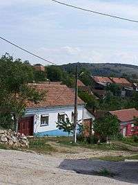
Street in Sfânta Elena
-
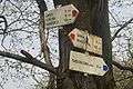
Czech-language signs marking the trails between Sfânta Elena and Gârnic
-

Gaura cu muscă, one of the caves around Coronini
Notes
- 1 2 3 (Romanian) Comunicat de presă privind rezultatele provizorii ale Recensământului Populaţiei şi Locuinţelor – 2011, Caraș-Severin County Regional Statistics Directorate; retrieved February 21, 2012
- ↑ Rieser, p.519
- 1 2 3 Pătroescu & Rozyłowicz, p.110
- ↑ G. Z. Földvary, Geology of the Carpathian Region, World Scientific, Singapore, 1988, p.493. ISBN 9971-5-0344-1
- 1 2 (Romanian) Situaţia ariilor naturale protejate constituite conform Legii 5/2003 şi H.G 2151/2004, Environmental Protection Agency Caraş-Severin release, p.1, 4; retrieved August 20, 2009
- ↑ (Romanian) "Coronini", at the Erdélyi Magyar Adatbank's Recensământ 2002 Archived March 20, 2012, at the Wayback Machine.; retrieved August 21, 2009
- 1 2 3 4 5 6 7 8 (Romanian) Sabin Adrian Luca, Arheologie şi istorie, Vol. I, Descoperiri din judeţul Caraş-Severin. Descoperiri arheologice C., Editura Economică, Bucharest, 2004. ISBN 973-709-067-5; e-book version at the Institute for the Study of Transylvania's Cultural Patrimony within a European Context, retrieved August 20, 2009
- 1 2 Pál Engel, The Realm of St. Stephen: A History of Medieval Hungary, 895-1526, I.B. Tauris, London, 2005, p.237-238. ISBN 978-1-85043-977-6
- ↑ Rieser, p.168-169, 251
- ↑ Rieser, p.168-169, 251-252
- 1 2 3 (Romanian) Mălin Bot, "Monstrul din Dunăre", in Adevărul, September 27, 2008
- 1 2 David Turnock, Aspects of Independent Romania's Economic History with Particular Reference to Transition for EU Accession, Ashgate Publishing, Aldershot, p.77. ISBN 978-0-7546-5892-4
- ↑ Nicolae Dolângă, "The Land of Nera", in the Romanian Cultural Institute's Plural Magazine Archived March 21, 2012, at the Wayback Machine., Nr. 27/2006
- 1 2 3 4 5 6 7 8 9 10 11 12 (Czech) Svatá Helena - Z historie, at the Sfânta Elena official site; retrieved August 20, 2009
- 1 2 3 4 Ian Willoughby, "The Czech Ethnic Minority in Romania", Radio Prague release, December 29, 2004
References
- Maria Pătroescu, Laurențiu Rozyłowicz, "Natural Transborder Parks: The Direction of Biodiversity Preservation in Romania", in Philippe Crabbé, Alan Holland, Laurențiu Rozyłowicz, Laura Westra (eds.), Implementing Ecological Integrity: Restoring Regional and Global Environmental and Human Health. NATO Science Series IV. Earth and Environmental Sciences, Vol. 1, Kluwer Academic Publishers, Dordrecht, 2000, p. 101-112. ISBN 0-7923-6352-3
- Hans-Heinrich Rieser, Das rumänische Banat: eine multikulturelle Region im Umbruch, Jan Thorbecke Verlag, Stuttgart, 2001. ISBN 3-7995-2510-6
Coordinates: 44°44′N 21°41′E / 44.733°N 21.683°E