Coronation Gulf
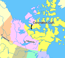
Coronation Gulf lies between Victoria Island and mainland Nunavut in Canada. To the northwest it connects with Dolphin and Union Strait and thence the Beaufort Sea and Arctic Ocean; to the northeast it connects with Dease Strait and thence Queen Maud Gulf.
The northwest point is Cape Krusenstern. South of that is Richardson Bay and the mouths (from west to east) of the Rae River, Richardson River and the large Coppermine River, Napaaktoktok River, and the Asiak River. The Tree River enters at the south center. At the southeast end is the large Bathurst Inlet. At the northeast end is Cape Flinders on the Kent Peninsula. In the center of the gulf lies the Duke of York Archipelago.
The gulf was named by Sir John Franklin in 1821, in honour of the coronation of King George IV. The environment and Native culture of the area were studied by Rudolph Anderson and Diamond Jenness in 1916 as part of the Canadian Arctic Expedition.[1]
The mainland south of the gulf may have substantial diamond and uranium deposits.
References
- ↑ "Coronation Gulf". THE CANADIAN ENCYCLOPEDIA. Retrieved August 18, 2015.
Coordinates: 68°07′59″N 112°00′00″W / 68.13306°N 112.00000°W