Coronado Heights


Coronado Heights is a hill northwest of Lindsborg, Kansas. It is alleged to be near the place where Francisco Vásquez de Coronado gave up his search for the seven cities of gold and turned around to return to Mexico.
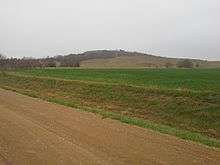
Coronado Heights is one of a chain of seven sandstone bluffs in the Dakota Formation and rises approximately 300 feet.[1]
In 1915 a professor at Bethany College in Lindsborg found chain mail from Spanish armor at an Indian village excavation site a few miles southwest of the hill,[2] and another Bethany College professor promoted the name of Coronado Heights for the hill. In 1920 the first road was built up the hill, known as Swensson Drive, with a footpath known as Olsson Trail. In 1936, a stone shelter resembling a castle was built on top of the hill as a project of the Works Progress Administration. In 1988 a sculpture by John Whitfield was placed half-way up the hill with the inscription "Coronado Heights 'A Place to Share'".[1]
The hill is now Coronado Heights Park, owned by the Smoky Valley Historical Association. Many visitors have carved their names or initials in the soft sandstone at the summit. It is possible to see for miles from the summit, and wildflowers bloom on the hill in spring and summer. In summer, there are many Cnemidophorus sexlineatus viridis lizards around the castle.
References
- 1 2 "Coronado Heights History" (PDF) (pdf). Lindsborg, Kansas. Retrieved November 29, 2015.
- ↑ Amy Bickel (September 2, 2007). "Swedish culture, Spanish lore, natural beauty merge in area". Hutchinson News. Retrieved December 12, 2008.
External links
Coordinates: 38°36′46″N 97°42′11″W / 38.61278°N 97.70306°W