Coron, Palawan
| Coron | |
|---|---|
| Municipality | |
 | |
 Map of Palawan with Coron highlighted | |
.svg.png) Coron Location within the Philippines | |
| Coordinates: 12°00′N 120°12′E / 12.000°N 120.200°ECoordinates: 12°00′N 120°12′E / 12.000°N 120.200°E | |
| Country | Philippines |
| Region | MIMAROPA (Region IV-B) |
| Province | Palawan |
| Congr. district | 1st district |
| Founded | 1902 |
| Barangays | 23 |
| Government | |
| • Mayor | Clara E. Reyes (LP) |
| • Vice Mayor | Jim Gerald L. Pe (LP) |
| Area[1] | |
| • Total | 689.10 km2 (266.06 sq mi) |
| Population (2010)[2] | |
| • Total | 42,941 |
| • Density | 62/km2 (160/sq mi) |
| Time zone | PST (UTC+8) |
| Zip Code | 5316 |
| Dialing code | 48 |
Coron is a first class municipality in the province of Palawan, Philippines, comprising the eastern half of Busuanga Island, all of Coron Island and about 50 other minor islets stretching as far as Tara Island in the north-east and Canipo Island in the south.[3] All these islands are part of the Calamian Archipelago in Northern Palawan that separates the South China Sea from the Sulu Sea. According to the 2010 census, it had a population of 42,941 people.[2]
The main population center of the municipality is composed of Poblacion Barangays 1 to 6, where the Municipal Building, the Municipal Legislative Building, and Judicial Hall of the Municipal Circuit Trial Court are located. Its fiesta is held annually on August 28 in honor of Saint Augustine. It is the commercial capital of the Calamian Islands.
Barangays
Coron is politically subdivided into 23 barangays.[1]
- Banuang Daan
- Bintuan
- Borac
- Buenavista
- Bulalacao
- Cabugao
- Decabobo
- Decalachao
- Guadalupe (also called Binalabag)
- Lajala
- Malawig
- Marcilla
- Barangay I (Pob.)
- Barangay II (Pob.)
- Barangay III (Pob.)
- Barangay IV (Pob.)
- Barangay V (Pob.)
- Barangay VI (Pob.)
- San Jose
- San Nicolas
- Tagumpay
- Tara
- Turda
History
The Calamianes Islands were originally inhabited by the Tagbanuas and the Calmiananen. A fort and church was built around 1670 by the Spaniards as part of the defenses along with Cuyo and Taytay against the Muslim slave raids in Libis, Culion . This became a settlement for two migrants to the Calamianes foremost among them were the families of a Cuyonon, Nicolas Manlavi, who served several years in Spanish Galleons and an Ilonggo from Jaro,Ilo-ilo Claudio Sandoval who later wed Nicolas' only daughter Evarista. The Sandoval clan of the Calamianes came from this union.
While their domiciles were in Culion, Nicolas Manlavi and the Sandoval farms and landholdings were on the island of Busuanga.
Late in the 1890s, an American naturalist, Dean Worcester journeyed through the Calamianes collecting specimens and staying briefly in Culion. At the turn of the century, he was appointed part of the First Philippine Commission becoming the Secretary of the Interior. He recommended Culion as the Philippine Leper Colony. This act forced the transfer of the Sandoval clan in 1900 to the various barrios of what is now Coron and Busuanga. The Coron town was settled by the family of Claudio Sandoval, and the other Sandovals settled in what is now Bintuan,Salvacion, Concepcion and Old Busuanga.
In 1950 the town of Busuanga was created from the barrios of Concepcion, Salvacion, Busuanga, New Busuanga, Buluang, Quezon, Calawit, and Cheey which used to belong to Coron.[4]
In 1954, the islands of Linapacan, Cabunlaoan, Niangalao, Decabayotot, Calibanbangan, Pical, and Barangonan were separated from Coron to form the town of Linapacan, Palawan.[5]
Demographics
| Population census of Coron | ||
|---|---|---|
| Year | Pop. | ±% p.a. |
| 1990 | 33,228 | — |
| 1995 | 27,040 | −3.79% |
| 2000 | 32,243 | +3.84% |
| 2007 | 40,007 | +3.02% |
| 2010 | 42,941 | +2.61% |
| Source: National Statistics Office[2][6] | ||
Climate
| Climate data for Coron, Palawan | |||||||||||||
|---|---|---|---|---|---|---|---|---|---|---|---|---|---|
| Month | Jan | Feb | Mar | Apr | May | Jun | Jul | Aug | Sep | Oct | Nov | Dec | Year |
| Record high °C (°F) | 37 (99) |
37 (99) |
33 (91) |
35 (95) |
36 (97) |
35 (95) |
36 (97) |
33 (91) |
32 (90) |
33 (91) |
33 (91) |
37 (99) |
37 (99) |
| Average high °C (°F) | 30 (86) |
30 (86) |
31 (88) |
31 (88) |
32 (90) |
30 (86) |
30 (86) |
29 (84) |
30 (86) |
30 (86) |
30 (86) |
30 (86) |
30.3 (86.5) |
| Daily mean °C (°F) | 27 (81) |
27 (81) |
28 (82) |
28 (82) |
29 (84) |
28 (82) |
27 (81) |
27 (81) |
27 (81) |
27 (81) |
28 (82) |
28 (82) |
27.6 (81.7) |
| Average low °C (°F) | 25 (77) |
25 (77) |
25 (77) |
26 (79) |
26 (79) |
26 (79) |
25 (77) |
25 (77) |
25 (77) |
25 (77) |
25 (77) |
25 (77) |
25.3 (77.5) |
| Record low °C (°F) | 20 (68) |
21 (70) |
21 (70) |
22 (72) |
22 (72) |
20 (68) |
22 (72) |
22 (72) |
22 (72) |
22 (72) |
22 (72) |
20 (68) |
20 (68) |
| Average rainfall mm (inches) | 6 (0.24) |
0 (0) |
12 (0.47) |
39 (1.54) |
117 (4.61) |
351 (13.82) |
435 (17.13) |
375 (14.76) |
159 (6.26) |
159 (6.26) |
45 (1.77) |
12 (0.47) |
1,710 (67.33) |
| Average rainy days | 2 | 1 | 3 | 4 | 17 | 25 | 26 | 24 | 20 | 19 | 9 | 4 | 154 |
| Average relative humidity (%) | 72 | 74 | 72 | 71 | 69 | 78 | 83 | 84 | 83 | 84 | 80 | 77 | 77.3 |
| Mean daily sunshine hours | 11.9 | 12.1 | 12.4 | 12.8 | 13.1 | 13.2 | 13.1 | 12.9 | 12.5 | 12.2 | 11.9 | 11.8 | 12.49 |
| Source #1: World Weather Online[7] | |||||||||||||
| Source #2: Weatherbase [8] | |||||||||||||
Economy
The main industries of Coron are fishing and tourism. Former industries include manganese mining at Singay Mines in Barangay San Nicolas during the Japanese Occupation period. This was followed by the fishing industry boom during the 1970s up to the 1990s which gradually dwindled due to illegal blast and sodium cyanide fishing. Almost along with fishing boom was the rattan and basket-weaving industry which also gradually declined due to the ensuing depletion of raw materials.
Currently tourism is the top industry in Coron and is a location of beaches, dive sites, and other natural tourist spots. A Dozen of sunken Japanese warships at depths between 10 and 40 metres (33 and 131 ft) off Coron Island is a diving destination,[3] listed in Forbes Traveler Magazine’s top 10 best scuba diving sites in the world.
Gallery

 Kayangan Lake
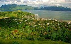
 View of the municipality from Mount Tapyas
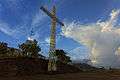 The cross in the summit of Mount Tapyas
Transportation
Air
By Plane - Getting to Coron (Busuanga Airport – Francisco B. Reyes Airport) from Manila (NAIA) is now very convenient with multiple airlines such as Cebu Pacific Air, Philippine Airlines and SkyJet Airlines that offers multiple flights a day except for night flights as the airport is not yet fully developed to accommodate flights at night.
Sea
By Ferry - 2Go Travel (formerly Superferry) cruises to Coron from Manila twice a week. You may check out their website for schedules 2GO Travel Schedules and select Coron, Palawan under destination.[9]
References
- 1 2 "Province: PALAWAN". PSGC Interactive. Makati City, Philippines: National Statistical Coordination Board. Archived from the original on 14 November 2012. Retrieved 12 November 2012.
- 1 2 3 "Total Population by Province, City, Municipality and Barangay: as of May 1, 2010" (PDF). 2010 Census of Population and Housing. National Statistics Office. Archived from the original (PDF) on 15 November 2012. Retrieved 7 November 2012.
- 1 2 "Coron" (PDF). Provincial Government of Palawan. Retrieved 12 November 2012.
- ↑ "An act to create the municipality of Busuanga in the province of Palawan". LawPH.com. Retrieved 2011-04-09.
- ↑ "An Act to Create the Municipality of Linapacan in the Province of Palawan". LawPH.com. Retrieved 2011-04-11.
- ↑ "Province of Palawan". Municipality Population Data. LWUA Research Division. Retrieved 18 July 2013.
- ↑ "Coron, Philippines: Average Temperatures and Rainfall". World Weather Online. Retrieved 15 September 2014.
- ↑ "Coron, Philippines Travel Weather Averages (Weatherbase)". Weatherbase. Retrieved 15 September 2014.
- ↑ "Traveling to Coron". Retrieved 21 September 2016.
External links
| Wikimedia Commons has media related to Coron, Palawan. |
| Wikivoyage has a travel guide for Coron. |
- Philippine Standard Geographic Code
- Local Governance Performance Management System
- Philippine Department of Tourism official site
 |
Mindoro Strait | Mindoro Strait / Magsaysay, Occidental Mindoro | | |
| Busuanga | |
|||
| ||||
| | ||||
| Culion | Sulu Sea / Agutaya |
Puerto Princesa (capital) | |
| Municipalities | |
| Highly urbanized city |
|