Cornell Road
 Cornell Road in Cedar Mill | |
| East end | NW Lovejoy Street in Portland |
|---|---|
| Major junctions |
Murray Blvd in Washington County NW 185th Avenue in Hillsboro Cornelius Pass Road in Hillsboro Brookwood Parkway in Hillsboro |
| West end | E Main Street in Hillsboro |
Cornell Road is an east–west street and traffic corridor in the Portland metropolitan area, in Multnomah and Washington counties in the U.S. state of Oregon. It crosses the Tualatin Mountains (West Hills) between the Willamette Valley and the city of Portland on the east and the Tualatin Valley and the city of Hillsboro on the west.[1]
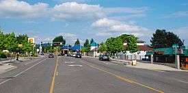
Cornell Road runs between the western end of Northwest Lovejoy Street in the Hillside neighborhood of Portland to East Main Street in Hillsboro, passing through unincorporated parts of Washington County and through Beaverton on the way. On the east side of its intersection with Cornelius Pass Road, it is called Northwest Cornell Road, as it lies within a section of Hillsboro where the compass directions in street names remain based on the Portland grid, and this section is in the northwest quadrant of the Portland-centered metropolitan area. On the west side of Cornelius Pass Road, it is called Northeast Cornell Road,[1] as it runs through the northeast quadrant of Hillsboro.
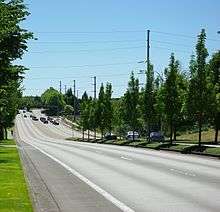
Although intended, on its section within the city of Portland, to be a neighborhood collector street with relatively low traffic volumes, it has often functioned as a major traffic street and commuter highway between downtown Portland and its western suburbs. It shares this role with more intensely busy traffic corridors along West Burnside Street and U.S. Route 26 (US 26).[2] The road has at least two lanes in each direction the entire length while south of US 26, while those portions north of US 26 are largely one-lane in each direction.
History

The first section of the road was already in existence in the 1850s.[3] It is named for William and Emily Cornell, who moved onto a donation land claim on what is now Cornell Road, just east of the present-day western boundary of Multnomah County, in 1852.[4] William Cornell worked as a preacher and Sunday-school teacher in the Cedar Mill area,[4] in nearby Washington County. Businessman John B. Yeon was the roadmaster as of 1915 for the Portland section, on what was described that year as "delightfully smooth" for the stretch in Portland.[5] Plans for the Pacific Highway from 1917 show Cornell joining it near present-day 185th, with that highway then continuing to downtown Hillsboro.[6] That highway was never built as such, but the alignment is similar to the route followed by U.S. 26 and Cornell's route from approximately 185th Avenue to its western terminus. The section between 185th and 173rd was widened to three lanes in 1981.[7]
Mass transit
The main TriMet bus line along Cornell Road is number 48-Cornell. Serving communities on the western side of the West Hills, it has stops between Northwest Cedar Hills Boulevard/Northwest 113th Avenue (opposite sides of the same intersection), in Cedar Mill, and Cornell Road's western terminus in Hillsboro.[8] This bus line continues west from the end of Northeast Cornell Road to the Hillsboro Transit Center, with connections to other bus lines and to the MAX Blue Line, linking Hillsboro to Beaverton, Portland, and other communities by light rail.[9]
Other bus lines stopping along shorter segments of Cornell Road include line 50-Cedar Mill, from Northwest 107th Avenue to Northwest Saltzman Road, and line 62-Murray Blvd., between Saltzman Road and Northwest Murray Boulevard. The easternmost segment between Northwest Lovejoy Street and Northwest Westover Road in Portland's Hillside neighborhood, is served by bus line 18-Hillside.[8]
Tunnels
Cornell Road passes through two tunnels drilled through basalt in the West Hills.[10] Laborers hired by the Works Progress Administration built both, the first and easternmost in 1940 and the second in 1941. Northwest Cornell Road Tunnel 1 is 500 feet (150 m) long and has a horizontal clearance of about 28 feet (8.5 m). Tunnel 2 is 250 feet (76 m) long with a horizontal clearance of about 27 feet (8.2 m). Both are lined with concrete and have portals of stone masonry.[11]
Realignment
The nearly 2-mile (3 km) current section of Cornell Road between N.W. 192nd Avenue and N.W. 229th Avenue was built as a completely new – and wider – alignment between about 1986 and 1995, to replace the original alignment on that section, which was located about one-fifth of a mile south of the current alignment. The section between 229th and Cornelius Pass Road opened in 1987,[12] while the section between Cornelius Pass Road and Stucki Avenue opened in stages in the mid-1990s, the final phase being the stretch between John Olsen Avenue/206th and Cornelius Pass Road, completed in 1995.[13] The old alignment had been two lanes wide, whereas the new one had four to five lanes. Some portions of the old alignment were abandoned,[12] but the section east of Cornelius Pass Road, initially renamed Old Cornell Road, became Amberwood Drive. The realignment projects, together with widening of certain other two-lane sections of Cornell to four or more lanes during that period, were intended by Hillsboro and Washington County officials to transform the road into a major arterial in the Beaverton–Hillsboro area, the "third-largest east–west thoroughfare" on the Portland metropolitan area's west side[13] (after the Sunset Highway/US 26 and Tualatin Valley Highway).
References
- 1 2 Google (October 14, 2015). "Northwest Cornell Road, Portland, Oregon" (Map). Google Maps. Google. Retrieved October 14, 2015.
- ↑ Portland Bureau of Transportation (1996). "NW Cornell Road – Lovejoy to Tunnel". City of Portland. Retrieved October 15, 2015.
- ↑ "Looking backward – and forward". The Sunday Oregonian. October 7, 1906. Section 1, p. 8. Retrieved October 28, 2015.
- 1 2 Baron, Connie (March 6, 2008). "Paths linking past and present". The Oregonian. Metro West Neighbors section, p. 10.
- ↑ "2 Beat Road Maze". The Sunday Oregonian. October 3, 1915. Section 4, p. 8.
- ↑ "Washington County Satisfied At Routing Of West Side Highway Via Orenco". The Sunday Oregonian. October 21, 1917. Section 2, p. 16.
- ↑ "Widened Cornell to reopen". The Oregonian. December 29, 1981. p. MW1.
- 1 2 TriMet (2015). Interactive System Map (Map). TriMet. Retrieved October 15, 2015.
- ↑ "Transit Centers". TriMet. 2015. Retrieved October 15, 2015.
- ↑ Bednarz, Susan L.; Gribbon, Paul T.; Gildner, Joseph p. (2011). "The History of Tunneling in Portland: Rails, Highways, and the Environment" (PDF). p. 4. Retrieved October 15, 2015.
- ↑ "Highway Tunnels of Oregon" (PDF). Oregon Department of Transportation. 2002. p. 2. Retrieved October 15, 2015.
- 1 2 Hill, Jim (November 13, 1987). "Section of Cornell Road at edge of Hillsboro opened". The Oregonian (West Metro ed.). p. F12.
- 1 2 Gonzalez, Christine (November 18, 1994). "Hillsboro leaders hail widening of Cornell Road". The Oregonian (West Metro ed.). p. D2.
External links
![]() Media related to Cornell Road at Wikimedia Commons
Media related to Cornell Road at Wikimedia Commons