Corinth, Vermont
| Corinth, Vermont | |
|---|---|
| Town | |
|
Blake Memorial Library, East Corinth village | |
 Corinth, Vermont | |
| Coordinates: 44°1′40″N 72°16′37″W / 44.02778°N 72.27694°WCoordinates: 44°1′40″N 72°16′37″W / 44.02778°N 72.27694°W | |
| Country | United States |
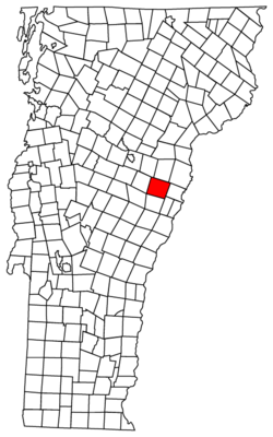
| State | Vermont |
| County | Orange |
| Area | |
| • Total | 48.6 sq mi (125.8 km2) |
| • Land | 48.5 sq mi (125.7 km2) |
| • Water | 0.0 sq mi (0.0 km2) |
| Elevation | 1,749 ft (533 m) |
| Population (2000) | |
| • Total | 1,461 |
| • Density | 30.1/sq mi (11.6/km2) |
| Time zone | Eastern (EST) (UTC-5) |
| • Summer (DST) | EDT (UTC-4) |
| ZIP code | 05039 |
| Area code(s) | 802 |
| FIPS code | 50-15700[1] |
| GNIS feature ID | 1462075[2] |

Corinth /kəˈrɪnθ/ is a town in Orange County, Vermont, United States. The population was 1,461 at the 2000 census.
Geography
According to the United States Census Bureau, the town has a total area of 48.5 square miles (125.7 km2), of which 48.5 square miles (125.7 km2) is land and 0.04 square mile (0.1 km2) (0.04%) is water. The Waits River flows through northeastern Corinth.[3]
Tim Burton's film Beetlejuice (1988) was filmed in East Corinth.[4] East Corinth is one of the most photographed New England foliage scenes. Local services include a general store, movie rental store, post office, doctor's office, library, and ball field.
Corinth comprises seven villages—East Corinth, West Corinth, South Corinth, Corinth Center, Corinth Corners, Cookeville, and Goose Green.
It has two zip codes - 05039 (Post Office located in Cookeville) and 05040 (Post Office located in East Corinth).
Demographics
| Historical population | |||
|---|---|---|---|
| Census | Pop. | %± | |
| 1790 | 578 | — | |
| 1800 | 1,410 | 143.9% | |
| 1810 | 1,876 | 33.0% | |
| 1820 | 1,907 | 1.7% | |
| 1830 | 1,953 | 2.4% | |
| 1840 | 1,970 | 0.9% | |
| 1850 | 1,906 | −3.2% | |
| 1860 | 1,627 | −14.6% | |
| 1870 | 1,470 | −9.6% | |
| 1880 | 1,627 | 10.7% | |
| 1890 | 1,027 | −36.9% | |
| 1900 | 978 | −4.8% | |
| 1910 | 1,005 | 2.8% | |
| 1920 | 936 | −6.9% | |
| 1930 | 817 | −12.7% | |
| 1940 | 822 | 0.6% | |
| 1950 | 786 | −4.4% | |
| 1960 | 775 | −1.4% | |
| 1970 | 683 | −11.9% | |
| 1980 | 904 | 32.4% | |
| 1990 | 1,244 | 37.6% | |
| 2000 | 1,461 | 17.4% | |
| 2010 | 1,367 | −6.4% | |
| Est. 2014 | 1,366 | [5] | −0.1% |
| U.S. Decennial Census[6] | |||
As of the census[1] of 2000, there were 1,461 people, 535 households, and 410 families residing in the town. The population density was 30.1 people per square mile (11.6/km2). There were 728 housing units at an average density of 15.0 per square mile (5.8/km2). The racial makeup of the town was 98.77% White, 0.21% African American, 0.21% Native American, 0.14% from other races, and 0.68% from two or more races. Hispanic or Latino of any race were 1.03% of the population.
There were 535 households out of which 36.4% had children under the age of 18 living with them, 60.4% were married couples living together, 9.3% had a female householder with no husband present, and 23.2% were non-families. 16.4% of all households were made up of individuals and 7.3% had someone living alone who was 65 years of age or older. The average household size was 2.73 and the average family size was 3.02.
In the town the population was spread out with 28.1% under the age of 18, 5.5% from 18 to 24, 28.4% from 25 to 44, 25.4% from 45 to 64, and 12.5% who were 65 years of age or older. The median age was 38 years. For every 100 females there were 99.3 males. For every 100 females age 18 and over, there were 97.4 males.
The median income for a household in the town was $32,198, and the median income for a family was $33,646. Males had a median income of $29,964 versus $23,646 for females. The per capita income for the town was $14,431. About 7.1% of families and 10.7% of the population were below the poverty line, including 12.2% of those under age 18 and 7.7% of those age 65 or over.
Notable people
- Tania Aebi, first American woman to sail solo around the world
- Reuben Robie, former US Congressman
- Alexander Twilight, first African American to serve in a state legislature and first African American confirmed to have received a degree from an American university
- Patricia Neway, operatic soprano and musical theater actress, lived there in retirement until her death in 2012
References
- 1 2 "American FactFinder". United States Census Bureau. Archived from the original on 2013-09-11. Retrieved 2008-01-31.
- ↑ "US Board on Geographic Names". United States Geological Survey. 2007-10-25. Retrieved 2008-01-31.
- ↑ DeLorme (1996). Vermont Atlas & Gazetteer. Yarmouth, Maine: DeLorme. ISBN 0-89933-016-9
- ↑ "15 famous fictional New England locales - A&E". Boston.com. 2013-02-20. Retrieved 2013-03-06.
- ↑ "Annual Estimates of the Resident Population for Incorporated Places: April 1, 2010 to July 1, 2014". Retrieved June 4, 2015.
- ↑ "U.S. Decennial Census". United States Census Bureau. Archived from the original on May 11, 2015. Retrieved May 16, 2015.
Municipalities and communities of Orange County, Vermont, United States | ||
|---|---|---|
| Towns | 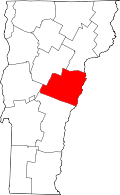 | |
| Villages | ||
| CDPs | ||
| Other communities | ||