Cordova Army Airfield
| Cordova Army Airfield | |||||||||||
|---|---|---|---|---|---|---|---|---|---|---|---|
 | |||||||||||
| IATA: none – ICAO: none | |||||||||||
| Summary | |||||||||||
| Airport type | Military | ||||||||||
| Owner | United States Army | ||||||||||
| Serves | Cordova, Alaska | ||||||||||
| Built | 1941 | ||||||||||
| Elevation AMSL | 12 ft / 4 m | ||||||||||
| Coordinates | 60°32′38″N 145°43′36″W / 60.54389°N 145.72667°WCoordinates: 60°32′38″N 145°43′36″W / 60.54389°N 145.72667°W | ||||||||||
| Map | |||||||||||
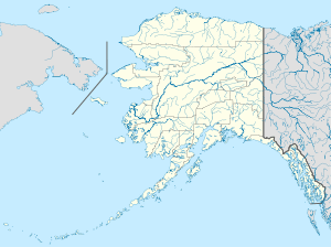 Cordova AAF Location of airport in Alaska | |||||||||||
| Runways | |||||||||||
| |||||||||||
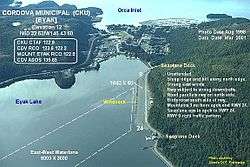
Cordova Army Airfield is a former United States Army airfield located one nautical mile (1.8 km) east of the central business district of Cordova, a city in the Valdez-Cordova Census Area of the U.S. state of Alaska.[1] Following its closure, it was redeveloped into Cordova Municipal Airport
See also
References
![]() This article incorporates public domain material from the Air Force Historical Research Agency website http://www.afhra.af.mil/.
This article incorporates public domain material from the Air Force Historical Research Agency website http://www.afhra.af.mil/.
- ↑ FAA Airport Master Record for CKU (Form 5010 PDF), effective 2008-09-25.
Previously: Alaskan Air Force (1941-1942) | |||||||||||||
| Bases |
| .svg.png) | |||||||||||
| Units |
| ||||||||||||
This article is issued from Wikipedia - version of the 9/24/2015. The text is available under the Creative Commons Attribution/Share Alike but additional terms may apply for the media files.