Cordillera Central (Colombia)
| Cordillera Central (Central Andes) | |
|---|---|
 | |
| Highest point | |
| Peak | Nevado del Huila [1] |
| Elevation | 5,364 m (17,598 ft) |
| Dimensions | |
| Length | 1,023 km (636 mi) north-south |
| Area | 129,737 km2 (50,092 sq mi) |
| Geography | |
| Country | Colombia |
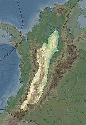
The Cordillera Central (English: Central Andes) is the highest of the three branches of the Colombian Andes. The range extends from south to north dividing from the Colombian Massif in Cauca Department to the Serranía de San Lucas in Bolivar Departments. The highest peak is Nevado del Huila at 5,364 m (17,598 ft).
Geography
The range is bounded by the Cauca and Magdalena river valleys to the west and east, respectively.
Highest Peaks
- Nevado del Huila - 5,364 m (17,598 ft)[2] - Cauca, Huila & Tolima
- Nevado del Ruiz - 5,311 m (17,425 ft) - Caldas & Tolima
- Nevado del Tolima - 5,215 m (17,110 ft) - Tolima
- Nevado de Santa Isabel - 5,100 m (16,700 ft) - Risaralda, Tolima & Caldas
- Nevado del Quindio - 4,760 m (15,620 ft) - Quindio, Tolima & Risaralda
- Cerro Pan de Azucar - 4,670 m (15,320 ft) - Cauca & Huila
- Puracé - 4,646 m (15,243 ft) - Cauca & Huila
Protected Areas
- PNN Los Nevados
- PNN Nevado del Huila
- PNN Puracé
- PNN Las Hermosas
- PNN Selva de Florencia
- SFF Otún Quimbaya
- SFF Serranía de las Minas - proposed
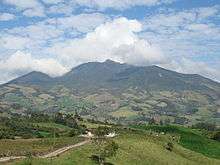
Cordillera Central, Antioquia Department
See also
- Geography of Colombia
- Andean Region, Colombia
- Cordillera Occidental (Colombia)
- Cordillera Oriental (Colombia)
References
- ↑ "Nevado del Huila, Colombia". Retrieved 20 February 2013.
- ↑ "Volcano Info: Nevado del Huila". Global Volcanism Program. Smithsonian Institution, National Museum of Natural History. Retrieved 29 June 2014.
Mountain Ranges of Colombia | ||||||||||||||||
|---|---|---|---|---|---|---|---|---|---|---|---|---|---|---|---|---|
| Colombian Andes |
| .svg.png) | ||||||||||||||
| Isolated Ranges | ||||||||||||||||
This article is issued from Wikipedia - version of the 1/23/2016. The text is available under the Creative Commons Attribution/Share Alike but additional terms may apply for the media files.