Corcovado Volcano
| Corcovado | |
|---|---|
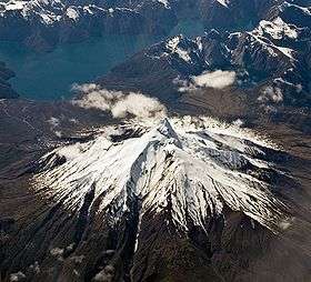 The volcano seen from the west on a commercial flight. | |
| Highest point | |
| Elevation | 2,300 m (7,500 ft) |
| Coordinates | 43°11′S 72°48′W / 43.183°S 72.800°WCoordinates: 43°11′S 72°48′W / 43.183°S 72.800°W |
| Geography | |
| Location | Chile |
| Parent range | Andes |
| Geology | |
| Mountain type | Stratovolcano |
| Last eruption | 4920 BCE ± 100 |
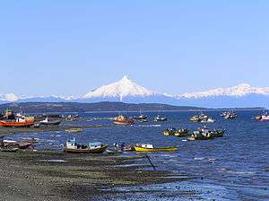
Corcovado Volcano (Spanish pronunciation: [korkoˈβaðo]) is a stratovolcano located about 25 kilometres (16 mi) south of the mouth of Yelcho River, in the Palena Province, Los Lagos Region, Chile. The glacially eroded volcano is flanked by Holocene cinder cones. The volcano's base has likely prehistoric lava flows that are densely vegetated. The most distinctive feature of this volcano is its stepped top, similar to that of Puntiagudo Volcano. At its foot lies a series of beautiful lakes. Corcovado dominates the landscape of Gulf of Corcovado area and is visible from the Chiloé Island, weather allowing.
The volcano and the adjacent area form part of Corcovado National Park. The town of Chaitén was formerly the main gateway to this protected area.
Eruptive history
Corcovado has two unconfirmed eruptions in 1834 and 1835 with lava flows from flank cones, which are probably based on confusion with Michinmahuida volcano. Three tephra layers are linked to Corcovado volcano, of which the two youngest are dated 7,980 BP and 6,870 BP respectively.
See also
- List of volcanoes in Chile
- Chaitén (volcano) - the volcano 40 km North of Corcovado which erupted on May 2, 2008.
- Yanteles - a little-known volcano located about 30 km (19 mi) south of Corcovado.
- 180 Degrees South: Conquerors of the Useless - a 2010 documentary directed by Chris Malloy that covers the journey of Jeff Johnson as he travels from Ventura, California to Patagonia, Chile to attempt to summit Corcovado.
References
- "Corcovado". Global Volcanism Program. Smithsonian Institution.
- González-Ferrán, Oscar (1995). Volcanes de Chile. Santiago, Chile: Instituto Geográfico Militar. p. 640 pp. ISBN 956-202-054-1. (in Spanish; also includes volcanoes of Argentina, Bolivia, and Peru)
- José A. Naranjo, Charles R. Stern (December 2004). "Holocene tephrochronology of the southernmost part (42°30'-45°S) of the Andean Southern Volcanic Zone". Revista Geológica de Chile. 31 (2): 225–240. doi:10.4067/S0716-02082004000200003 – via SciELO.