Coralville, Iowa
| Coralville, Iowa | ||
|---|---|---|
| City | ||
|
City Center Square in downtown Coralville | ||
| ||
 Location of Coralville, Iowa | ||
| Coordinates: 41°41′18″N 91°35′12″W / 41.68833°N 91.58667°WCoordinates: 41°41′18″N 91°35′12″W / 41.68833°N 91.58667°W | ||
| Country |
| |
| State |
| |
| County | Johnson | |
| Metro | Iowa City Metropolitan Area | |
| Incorporated | 1873 | |
| Government | ||
| • Type | Council-manager government | |
| • Mayor | John Lundell | |
| • City Administrator | Kelly Hayworth | |
| Area[1] | ||
| • Total | 12.05 sq mi (31.21 km2) | |
| • Land | 12.01 sq mi (31.11 km2) | |
| • Water | 0.04 sq mi (0.10 km2) | |
| Elevation | 682 ft (208 m) | |
| Population (2010)[2] | ||
| • Total | 18,907 | |
| • Estimate (2013[3]) | 20,092 | |
| • Rank | 23rd in Iowa | |
| • Density | 1,574.3/sq mi (607.8/km2) | |
| Time zone | Central (CST) (UTC-6) | |
| • Summer (DST) | CDT (UTC-5) | |
| ZIP code | 52241 | |
| Area code(s) | 319 | |
| FIPS code | 19-16230 | |
| GNIS feature ID | 0455624 | |
| Website | www.coralville.org | |

Coralville is a city in Johnson County, Iowa, United States. It is a suburb of Iowa City and part of the Iowa City Metropolitan Statistical Area. The population was 18,907 at the 2010 census.
History
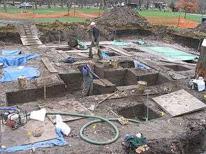

Coralville is the location of the Edgewater Park Site, a 3,800-year-old archaeological site along the Iowa River. Edgewater is the oldest site in Iowa with evidence of domesticated plant use.
Coralville incorporated as a city in June first, 1857. The city's name comes from the fossils that are found in the limestone along the Iowa River. In 1864 Louis Agassiz, a Harvard University zoologist, gave a lecture at the nearby University of Iowa titled “The Coral Reefs of Iowa City”.[4] During the lecture he presented local samples of fossilized Devonian period coral. The lecture was well received and helped raise public interest in the local fossils. In 1866, more corals were discovered at the site of a new mill, inspiring the citizens of the area to name the settlement "Coralville".[5] The first mill at Coralville was built in 1844, and in the years that followed, a number of mills were powered by the Coralville mill dam along the Iowa River, but all of the mills had closed by 1900, except for a low-head hydroelectric plant that remained in operation until the mid 20th century.
Coralville is also the location where some 1300 Mormon immigrants stopped to make camp in their migration of 1856 after having traveled west by rail to Iowa City, which was the westernmost rail terminus at the time. They built handcarts out of native woods during their encampment so that an adult could haul a 600–700 pound load and cover about 15 miles per day on foot in their continuing trek to Salt Lake City. A historical marker commemorating the Mormon Handcart Brigade was erected in 1936 by the Iowa Society DAR, with members of the Pilgrim Chapter present. Originally placed just south of 5th Street and west of 10th Street, it was moved in 1998 to S. T. Morrison Park and rededicated by the Nathaniel Fellows Chapter, placed near the entrance and pond. Today, the Mormon Handcart Park and Nature Preserve commemorates the site. There is also a street, Mormon Trek Blvd, named for the Mormons who went through that area.
After World War II Coralville began to grow as many university students began to make their homes there. It had only 433 people in 1940, but by 1970 Coralville's population had jumped to 6,130.[6] The construction of Interstate 80 in the 1960s brought several motels, fast-food restaurants, and gas stations to Coralville.
By the mid-1960s, the independent school district of Coralville was annexed by the Iowa City Community School District. Junior and senior high school students rode buses into Iowa City. Elementary (K-6) students attended Central Elementary School. Kirkwood Elementary school was opened in the fall of 1964, giving the growing town its second school. By the fall of 1968, all high school students from Coralville began attending the newly opened West High School. In 1971 the district built Northwest Junior High on property just to the south of Kirkwood Elementary, which then began handling 7th and 8th graders who lived west of the Iowa River. In 1997 Wickham Elementary School was opened.
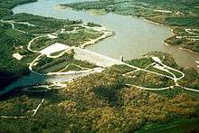
In 1958 the United States Army Corps of Engineers completed Coralville Dam along the Iowa River four miles (6 km) north of the city, creating Coralville Lake. Except for the Great Flood of 1993 and the Great Iowa flood of 2008, the dam has helped prevent serious flooding in the city. From June through August 1993, all three of Coralville's main transportation links with Iowa City were submerged. The economic impact that year was severe, but the city had almost fully recovered within two years. The 2008 flood proved to be more costly as the Iowa River surpassed the 1993 record crest at over 31.5 feet (9.6 m).
The First Methodist Church (Coralville, Iowa) was built 1963 to the designs by architect Thomas Patrick Reilly of Crites & McConnell, 860 17th Street S.E, Cedar Rapids, Iowa 52403.[7]
On July 29, 1998, the Coral Ridge Mall opened with more than 100 stores, then the largest shopping center in the state. Around that time a "city center" area was created along the U.S. Route 6 "strip" near its intersection with 12th Avenue. Coral Ridge Mall's opening would usher in a new era of retail development as big box stores such as Wal-Mart, Kohl's, and Lowe's opened in the area surrounding the mall. This has helped boost taxable sales in Coralville from $155.3 million in 1996 to $549.7 million in 2006.[8]
Coralville is also home to the Iowa Firefighter's Memorial, located just off I-80 at the First Avenue exit.
Geography

Coralville is located in Johnson County at 41°41′18″N 91°35′12″W / 41.68833°N 91.58667°W (41.688215, -91.586764).[9]
According to the United States Census Bureau, the city has a total area of 12.05 square miles (31.21 km2), of which, 12.01 square miles (31.11 km2) is land and 0.04 square miles (0.10 km2) is water.[1]
The Iowa River runs along the east edge of Coralville and forms part of the boundary with Iowa City. Interstate 80 runs east-west through Coralville, and most of the city's newer housing subdivisions are located north of I-80. U.S. Highway 6 runs along Coralville's south edge, while Interstate 380, U.S. Highway 218, and Iowa Highway 27 (the Avenue of the Saints) run along the city's west edge. The cloverleaf interchange of I-80 and I-380/U.S. 218/Iowa 27 is divided between the city limits of Coralville and neighboring Tiffin after recent annexations.
Demographics
| Historical populations | ||
|---|---|---|
| Year | Pop. | ±% |
| 1880 | 347 | — |
| 1890 | 173 | −50.1% |
| 1900 | 125 | −27.7% |
| 1910 | 151 | +20.8% |
| 1920 | 150 | −0.7% |
| 1930 | 254 | +69.3% |
| 1940 | 433 | +70.5% |
| 1950 | 977 | +125.6% |
| 1960 | 2,357 | +141.2% |
| 1970 | 6,130 | +160.1% |
| 1980 | 7,687 | +25.4% |
| 1990 | 10,347 | +34.6% |
| 2000 | 15,123 | +46.2% |
| 2010 | 18,907 | +25.0% |
| 2014 | 20,349 | +7.6% |
| 2015 | 20,608 | +1.3% |
| [10] Source: | ||
2010 census
As of the census[2] of 2010, there were 18,907 people, 7,763 households, and 4,229 families residing in the city. The population density was 1,574.3 inhabitants per square mile (607.8/km2). There were 8,310 housing units at an average density of 691.9 per square mile (267.1/km2). The racial makeup of the city was 79.4% White, 7.9% African American, 0.3% Native American, 7.8% Asian, 0.1% Pacific Islander, 2.0% from other races, and 2.6% from two or more races. Hispanic or Latino of any race were 5.1% of the population.
There were 7,763 households of which 29.4% had children under the age of 18 living with them, 42.8% were married couples living together, 8.5% had a female householder with no husband present, 3.2% had a male householder with no wife present, and 45.5% were non-families. 33.0% of all households were made up of individuals and 5% had someone living alone who was 65 years of age or older. The average household size was 2.29 and the average family size was 3.01.
The median age in the city was 31.6 years. 22.3% of residents were under the age of 18; 11.6% were between the ages of 18 and 24; 36.5% were from 25 to 44; 22.2% were from 45 to 64; and 7.5% were 65 years of age or older. The gender makeup of the city was 51.5% male and 48.5% female.
2000 census
As of the census[12] of 2000, there were 15,123 people, 6,467 households, and 3,317 families residing in the city. The population density was 1,484.1 people per square mile (573.0/km²). There were 6,754 housing units at an average density of 662.8 per square mile (255.9/km²). The racial makeup of the city was 86.97% White, 4.23% African American, 0.34% Native American, 5.20% Asian, 0.06% Pacific Islander, 1.07% from other races, and 2.14% from two or more races. Hispanic or Latino of any race were 3.04% of the population.
There were 6,467 households out of which 28.1% had children under the age of 18 living with them, 40.3% were married couples living together, 8.1% had a female householder with no husband present, and 48.7% were non-families. 34.9% of all households were made up of individuals and 4.3% had someone living alone who was 65 years of age or older. The average household size was 2.21 and the average family size was 2.96.
21.9% of the population are under the age of 18, 15.2% from 18 to 24, 40.9% from 25 to 44, 16.4% from 45 to 64, and 5.5% who were 65 years of age or older. The median age was 30 years. For every 100 females there were 104.2 males. For every 100 females age 18 and over, there were 105.6 males.
The median income for a household in the city was $38,080, and the median income for a family was $57,869. Males had a median income of $35,288 versus $30,356 for females. The per capita income for the city was $23,283. About 6.1% of families and 10.1% of the population were below the poverty line, including 9.5% of those under age 18 and 3.2% of those age 65 or over.
Media
Coralville has one licensed low-power FM station, KOUR-LP at 92.7 FM.[13] KCJJ 1630 AM, which is licensed to Iowa City, began broadcasting from studios in Coralville's Iowa River Landing in 2007.
Coralville and Johnson County are part of the Cedar Rapids media market. Mediacom is the city's cable television provider.
Notable people
- Nate Kaeding, San Diego Chargers and former University of Iowa placekicker.
- Jason McCartney, professional cyclist, Team RadioShack.
- Samuel J. Kirkwood, Governor of Iowa, Senator from Iowa, Secretary of the Interior.
- Steven B. Jepson, opera and musical theater singer.
References
- 1 2 "US Gazetteer files 2010". United States Census Bureau. Archived from the original on 2012-07-14. Retrieved 2012-05-11.
- 1 2 "American FactFinder". United States Census Bureau. Retrieved 2012-05-11.
- ↑ "Population Estimates". United States Census Bureau. Retrieved 2014-08-05.
- ↑ "Prof. Agassiz's lecture." Iowa City Republican, March 9, 1864.
- ↑ "A new town." Iowa State Press, December 19, 1866.
- ↑ City of Coralville, Iowa. "Coralville History". Retrieved 2006-08-16.
- ↑ "Thomas Patrick Reilly" American Architects Directory, Third Edition (New York City: R.R. Bowker LLC, 1970), p.741.
- ↑ City of Iowa City, Iowa. "City of Iowa City 2007 Community Profile: Retail and Wholesale Trade" (PDF). p. 52. Retrieved 2008-08-24.
- ↑ "US Gazetteer files: 2010, 2000, and 1990". United States Census Bureau. 2011-02-12. Retrieved 2011-04-23.
- ↑ "United States Census estimates". United States Census Bureau. Retrieved 2013-05-25.
- ↑ "Census of Population and Housing". Census.gov. Archived from the original on May 11, 2015. Retrieved June 4, 2015.
- ↑ "American FactFinder". United States Census Bureau. Archived from the original on 2013-09-11. Retrieved 2008-01-31.
- ↑ Northpine.com. "Iowa Radio Stations". Retrieved 2008-01-26.
External links
| Wikimedia Commons has media related to Coralville, Iowa. |
- Official City of Coralville Website Homepage
- Iowa City/Coralville Area Convention and Visitors Bureau
- Iowa City Area Chamber of Commerce
- City Data Comprehensive Statistical Data and more about Coralville
Municipalities and communities of Johnson County, Iowa, United States | ||
|---|---|---|
| Cities | ||
| Townships | ||
| CDP | ||
| Other unincorporated communities | ||
| Ghost town | ||
| Footnotes | ‡This populated place also has portions in an adjacent county or counties | |