Coppett's Wood and Scrublands
Coppett's Wood and Scrublands is a 14.5 hectare Site of Borough Importance for Nature Conservation, Grade I, between Muswell Hill and Friern Barnet in the London Borough of Barnet.[1][2] It is part of the Coppett's Wood and Glebelands Local Nature Reserve.[3][4]
The main trees are oak and hornbeam, and ground flora include bluebell and garlic mustard. Breeding birds include woodpeckers, tawny owls and sparrowhawks. A small pond has a clump of yellow iris, and common frogs and smooth newts. Scrublands has a variety of habitats and some rare plants such as imperforate St John's-wort. There are several rare species of insects.[1]
Coppett's Wood was once part of a forest known as Finchley Wood. By the sixteenth century it had shrunk in size and became known as a common, and in the seventeenth and eighteenth centuries it was used for pursuits such as bare-knuckle boxing, horse racing and pigeon shooting. It also had a reputation as a haunt of highwaymen. In the nineteenth century a sewage works was built on the site. It was closed in 1963, but still has its legacy in the rich variety of plants in the Scrublands. In the Second World War it was used for military training, and several tank traps still remain.[5]
Access to the site is from Colney Hatch Lane and North Circular Road.
Coppetts is also a ward of the London Borough of Barnet. At 2011 Census the ward population was 17,250.[6]
Gallery
-

Coppett's Wood path
-

Coppett's Wood
-
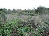
Scrublands
-
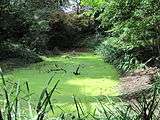
Pond at Coppett's Wood
See also
References
- 1 2 "Coppett's Wood and Scrubland LNR". Greenspace Information for Greater London. 2006. Retrieved 6 September 2012.
- ↑ "iGiGL – helping you find London's parks and wildlife sites". Greenspace Information for Greater London. 2006. Archived from the original on 2012-10-15.
- ↑ "Coppetts Wood and Glebelands". Local Nature Reserves. Natural England. 4 March 2013. Retrieved 22 January 2014.
- ↑ "Map of Coppetts Wood and Glebelands". Local Nature Reserves. Natural England. Retrieved 22 January 2014.
- ↑ Coppett's Wood noticeboard
- ↑ "Barnet Ward population 2011". Neighbourhood Statistics. Office for National Statistics. Retrieved 19 October 2016.
External links
- Coppett's Wood and Scrublands Local Nature Reserve, London Gardens Online
- Coppetts Wood and Glebelands LNR website This also covers the neighbouring Glebelands Local Nature Reserve.
- Coppetts Wood on the Woodland Trust website
Further reading
- Hewlett, Janet (1997). Nature Conservation in Barnet. London Ecology Unit. ISBN 1 871045 27 4.
Coordinates: 51°36′31″N 0°09′27″W / 51.6087°N 0.1574°W