Coppermine River
| Coppermine River | |
 View of the Arctic Sea from the mouth of the Coppermine River (1821) by George Back | |
| Country | Canada |
|---|---|
| Source | Lac de Gras |
| - location | Northwest Territories, Canada |
| - elevation | 396 m (1,299 ft) |
| - coordinates | 64°35′01″N 111°11′33″W / 64.58361°N 111.19250°W |
| Mouth | Coronation Gulf |
| - location | Nunavut, Arctic Ocean, Canada |
| - elevation | 0 m (0 ft) |
| - coordinates | 67°48′43″N 115°05′05″W / 67.81194°N 115.08472°WCoordinates: 67°48′43″N 115°05′05″W / 67.81194°N 115.08472°W |
| Length | 845 km (525 mi) |
 Coppermine River mouth location
| |
| [1][2] | |
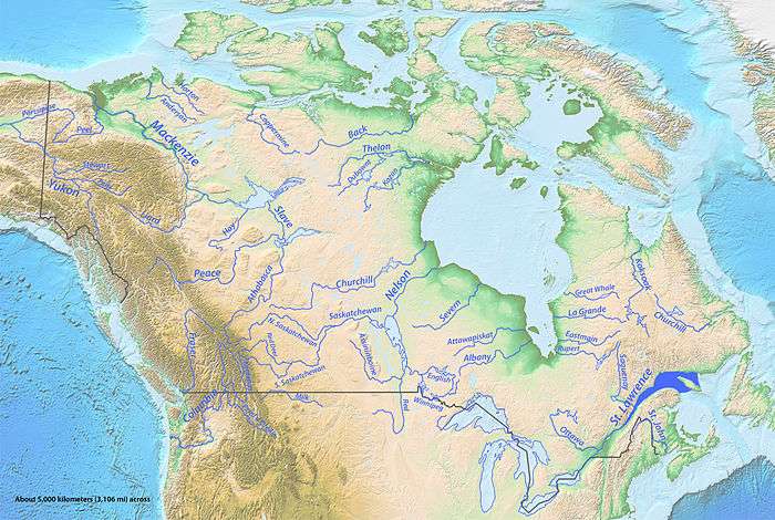
The Coppermine River is a river in the North Slave and Kitikmeot regions of the Northwest Territories and Nunavut in Canada. It is 845 kilometres (525 mi)[3] long. It rises in Lac de Gras, a small lake near Great Slave Lake and flows generally north to Coronation Gulf, an arm of the Arctic Ocean. The river freezes in winter but may still flow under the ice.
The community of Kugluktuk (formerly Coppermine) is located at the river's mouth.
The river was named for the copper ores which could be found along the lower river. Samuel Hearne travelled down the river to the Arctic Ocean in 1771. Sir John Franklin also travelled down the river during the Coppermine Expedition of 1819–1822. In 1826 its mouth was reached by John Richardson who followed the coast from the Mackenzie River.
Bloody Falls, part of the Kugluk/Bloody Falls Territorial Park, is located 18.5 kilometres (11.5 mi) from Kugluktuk, and was home to the Kogluktogmiut a sub-group of the Copper Inuit. It is the site of the Bloody Falls Massacre, when Matonabbee, Samuel Hearne's guide, and his fellow Chipewyan warriors ambushed and massacred the local Inuit.
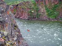
The river is used for wilderness canoeing and rafting, although it sees only a few groups each year. It features major rapids, such as Rocky Defile, Sandstone, Muskox, and Escape Rapids, as well as many unnamed smaller sets. Bloody Falls is the final major rapid of the river, and must be portaged.
The Coppermine River is the namesake of Coppermine Herald at the Canadian Heraldic Authority.
Geology of the region
Eruption of plateau lavas near the Coppermine River (the Coppermine River Group) built an extensive volcanic plateau about 1,200 million years ago with an area of about 170,000 square kilometres (66,000 sq mi) representing a volume of lavas of at least 500,000 cubic kilometres (120,000 cu mi). These lavas were formed during the same time as the large Muskox intrusion and the extensive Mackenzie dike swarm to the southeast. The lavas are thought to have originated from a mantle plume center called the Mackenzie hotspot.
Gallery
 Canoeists camping along river |
 One of many waterfalls along the river |
 Canoeing the Rocky Defile |
 Bloody Falls |
See also
- List of longest rivers of Canada
- List of rivers of the Northwest Territories
- List of rivers of Nunavut
References
- ↑ "Natural Resources Canada-Canadian Geographical Names (Coppermine River)". Retrieved 2014-08-29.
- ↑ "Atlas of Canada Toporama". Retrieved 2014-08-29.
- ↑ Coppermine river at the Atlas of Canada
Further reading
- Dredge, L. A. Where the river meets the sea geology and landforms of the lower Coppermine River Valley and Kugluktuk, Nunavut. [Ottawa]: Geological Survey of Canada, 2001. ISBN 0-660-18550-4
- Steele, Peter. The Man Who Mapped The Arctic: The Intrepid Life of George Back, Franklin's Lieutenant, 2003. ISBN 978-1551926483
External links
| Wikimedia Commons has media related to Coppermine River. |
- Coppermine Heritage River - Nunavut Parks
- Coppermine Heritage River
 "Coppermine River". The American Cyclopædia. 1879.
| Rivers |
|
|---|---|
| Nominated | |
| |