Copperas Mine Fork
| Copperas Mine Fork | |
| Country | United States |
|---|---|
| State | West Virginia |
| County | Logan |
| Source | |
| - location | western Logan County |
| - elevation | 1,413 ft (431 m) [1] |
| - coordinates | 37°49′48″N 82°07′29″W / 37.83000°N 82.12472°W [2] |
| Mouth | Island Creek |
| - location | Mount Gay |
| - elevation | 667 ft (203 m) [1] |
| - coordinates | 37°50′30.1″N 82°00′30.1″W / 37.841694°N 82.008361°WCoordinates: 37°50′30.1″N 82°00′30.1″W / 37.841694°N 82.008361°W [1] |
| Length | 9.3 mi (15 km) |
| Basin | 45.4 sq mi (118 km2) |
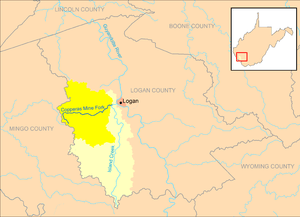 Copperas Mine Fork and its watershed, highlighted within the larger Island Creek watershed in Logan County, West Virginia.
| |
Copperas Mine Fork is a tributary of Island Creek, 9.3 miles (15.0 km) long,[3] in southern West Virginia in the United States. Via Island Creek and the Guyandotte and Ohio rivers, it is part of the watershed of the Mississippi River, draining an area of 45.4 square miles (118 km2)[4] in a rural area on the unglaciated portion of the Allegheny Plateau, in the Logan Coalfield. The Copperas Mine Fork's entire course and drainage area are in Logan County.[5]
The Copperas Mine Fork rises in western Logan County, along its boundary with Mingo County, and flows generally eastward through the unincorporated communities of Sulphur Springs, Beebe, Holden, and Cora, to Mount Gay, where it flows into Island Creek from the west, approximately 1 mile (1.6 km) west of the city of Logan.[5]
See also
References
- 1 2 3 Google Earth elevation for GNIS and National Map coordinates. Retrieved on 2011-10-25.
- ↑ Geographic Names Information System. "Geographic Names Information System entry for Copperas Mine Fork (Feature ID #1537675)". Retrieved 2011-10-25.
- ↑ United States Environmental Protection Agency. "Watershed Assessment, Tracking & Environmental Results: Assessment Summary for Reporting Year 2008, West Virginia, Upper Guyandotte Watershed". Archived from the original on 2011-10-15. Retrieved 2011-10-25.
- ↑ West Virginia Department of Environmental Protection. "HUC 8-12 Watersheds" (PDF). Archived from the original (PDF) on 2011-10-12. Retrieved 2011-10-25. HUC 12 watershed 050701010401, totaling 29075.17 acres.
- 1 2 West Virginia Atlas & Gazetteer. Yarmouth, Me.: DeLorme. 1997. pp. 51, 57. ISBN 0-89933-246-3.