Copper River Highway
| |
|---|---|
 | |
| Route information | |
| Maintained by AkDOT&PF and the NFS | |
| Length: | 49.5 mi[1] (79.7 km) |
| Major junctions | |
| South end: | 2nd Street in Cordova |
| North end: | The Million Dollar Bridge over the Miles Glacier |
| Highway system | |


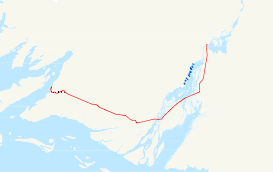
The Copper River Highway extends 49.5 miles (79.7 km) from Cordova along the old railbed of the Copper River and Northwestern Railway. Construction began in 1945, and was originally intended to link Cordova with the state highway system at Chitina. The Million Dollar Bridge, which had carried trains until the CR&NW shut down, was converted for highway use. It is one of two discontinuous segments of Alaska Route 10.
The road extended only slightly beyond the bridge when the Good Friday earthquake of 1964 halted construction and severely damaged the Million Dollar Bridge, collapsing the north span. Temporary repairs were made, and the bridge continued to be used. Permanent repairs were not completed until 2005.
The first 12 miles (19 km) of the highway is paved; the rest is gravel. A primitive four-wheel-drive road continues for 10 miles (16 km) beyond the end of the highway to the Allen River.
Route description
The Copper River Highway begins at the Alaska Marine Highway ferry terminal in Cordova. From there, the highway proceeds through central Cordova, intersecting several small roads and passing residential and commercial buildings.[2] The road exits Cordova, and passes the large Eyak Lake, proceeding to the Merle K. (Mudhole) Smith Airport.[2] The highway proceeds through Chugach National Forest, and passes over the Copper River, and several small sloughs.[2] The roadway continues north, passing through several miles of Chugach National Forest, before reaching the Million Dollar Bridge, the highway's northern terminus.[2]
Major junctions
The entire route is in Valdez-Cordova Borough.
| Location | mi[3] | km | Destinations | Notes | |
|---|---|---|---|---|---|
| Cordova | 0.000 | 0.000 | Western terminus | ||
| 0.449 | 0.723 | Railroad Avenue | |||
| 0.849 | 1.366 | Council Avenue | |||
| 1.095 | 1.762 | 2nd Street | |||
| 1.376 | 2.214 | Point Whitshed Road | |||
| 1.793 | 2.886 | Le Fevre Street | |||
| 4.831 | 7.775 | 5 Mile Cutoff | |||
| | 5.307 | 8.541 | Eyak River | ||
| | 13.696 | 22.042 | Sheridan Glacier Road | ||
| | 22.284 | 35.863 | Alaganik Slough Bridge | ||
| | 49.458 | 79.595 | Million Dollar Bridge | Eastern terminus | |
| 1.000 mi = 1.609 km; 1.000 km = 0.621 mi | |||||
References
- ↑ Staff. "The Copper River Highway". The Milepost. Retrieved April 23, 2012.
- 1 2 3 4 Google (May 31, 2012). "Overview Map of Copper River Highway" (Map). Google Maps. Google. Retrieved May 31, 2012.
- ↑ Birkholz, Ethan (2010). Annual Traffic Volume Report (PDF) (Report) (2008-2009-2010 ed.). Alaska Department of Transportation & Public Facilities. Route Number 210000. Retrieved May 31, 2012.