Cooranbong, New South Wales
| Cooranbong City of Lake Macquarie, New South Wales | |
|---|---|
| Population | 5,030 (2011 census)[1] |
| • Density | 1,118/km2 (2,900/sq mi) |
| Established | 1826 |
| Postcode(s) | 2265 |
| Area | 4.5 km2 (1.7 sq mi) |
| Location | |
| LGA(s) | City of Lake Macquarie |
| Parish | Coorumbung |
| State electorate(s) | Lake Macquarie |
| Federal Division(s) | Charlton |
Cooranbong is a town and rural suburb of the City of Lake Macquarie in New South Wales, Australia, west of the town of Morisset off the Sydney-Newcastle Freeway. Cooranbong is surrounded by the Watagans National Park.
The town's name is derived from the Aboriginal word "Kour-an-bong", meaning "rocky bottom creek" or "water over rocks".[2]
History
Prior to settlement and development of the area now known as Cooranbong, lived people who identify as part of the Awabakal group. It is unknown as to how long the people lived collectively as a single group and the nature of their interactions through peace and conflict with other people not of their own kin.
The first modern settler was Lieutenant Percy Simpson, who received a 2,000-acre (809 ha) land grant from the government and was assigned six convicts who cleared the land, grazed cattle and built a homestead near Dora Creek. Although Simpson only stayed there for two years, one of his convicts, Moses Carroll, became a stockman in the area, eventually becoming the area's police constable. The Robertson Land Act of 1861 allowed the town to grow, encouraging the construction of a Catholic church and later, a school, police station and courthouse (1873), a post office (1881) and an Anglican church. Timber cutting was the primary economic activity, during the 1880s the population reached 700.
When the railway was built from Sydney to Newcastle in the 1880s, the line passed around 5 km east of the town centre. The station and associated settlement were originally labelled as Cooranbong but later became known as Morisset. This was devastating to the local economy in conjunction with the significant economic depression occurring in the colony. Consequently, the population declined to 206 people by 1891. This economic depression continued until the Seventh-day Adventist Church bought 1,500 acres (607 ha) on the northern bank of Dora Creek where they built Avondale College (1897) and Sanitarium Health Food Company (1909).
Present day
The Avondale Estate[3] is a Seventh-day Adventist owned estate opposite the Cooranbong shops. The estate is home to Avondale College, a Seventh-day Adventist tertiary education institution, the Sanitarium Health and Wellbeing Company, Avondale College Church, Avondale Memorial Church, a disused dairy farm and Avondale Retirement Village. A number of Avondale College students and staff also live on the estate in off-campus housing.
There is also St Patrick's & St Brigid's Catholic Church, a small church built in 1906 to replace the original 1861 structure. The oldest headstone in its cemetery dates to 1862.[4]
South Sea Islands Museum
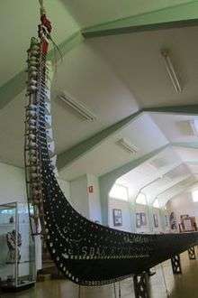
The South Sea Islands Museum is located at 27 Avondale Road adjacent to the Sunnyside Historical Home which was originally built by Ellen G. White. The museum contains a collection of historic South Sea Island artefacts gathered by Seventh-day Adventist missionaries during their work on Pitcairn Islands, Cook Islands, Samoa, Tonga, Fiji, the New Hebrides (now Vanuatu), the Solomon Islands, Papua New Guinea, New Caledonia and Kiribati. Its centerpiece is an enormous war canoe.[4] The records of the missionaries' work in Australia and in the South Sea Island region dating from the 1880s are held in the Adventist Heritage Centre at Cooranbong. According to the Australian Department of the Environment and Heritage, "these rich and diverse records of provenance add to the significance of items in the museum."[5]
Education
Cooranbong Public School (P-6, public)
Avondale School (P-12, private Christian)
Demographics
At the 2011 census, 5030 people lived in the Cooranbong area.[1] The median age of Cooranbong residents was 40 years, compared with 38 years as the News South Wales median. By far the highest religious affiliation was Seventh-day Adventist at 32.7%, compared to 0.3% in New South Wales. This was followed by Anglican 15.7%, No Religion 13.9%, and Catholic 10.8%. The median weekly household income was $1053.
References
- 1 2 Australian Bureau of Statistics (31 October 2012). "Cooranbong (State Suburb)". 2011 Census QuickStats. Retrieved 24 December 2012.
- ↑ "History of Cooranbong". City of Lake Macquarie. Retrieved 25 July 2014.
- ↑ http://library.ellenwhite.org/content/file/avondale-estate-cooranbong-nsw-australia-color?numFound=12608&collection=true&curr=4259&sqid=595533050&f[0]=bundle%3Afiles#image
- 1 2 Sydney Morning Herald (8 February 2004). "Cooranbong". Retrieved 2 April 2016.
- ↑ Russell, Roslyn and Winkworth, Kylie (2010). "Provenance across the collections of an archive, library and museum". Significance 2.0: a guide to assessing the significance of collections. Australian Department of the Environment and Heritage. ISBN 9780977544363. Online version retrieved 3 April 2016.
Further reading
- Cooranbong, First Town in Lake Macquarie, 1826–1996: A History Including Martinsville and Dora Creek by Michael Chamberlain (description). ISBN 0-646-32958-8
External links
| Wikimedia Commons has media related to Cooranbong, New South Wales. |
- History of Cooranbong
- Cooranbong Community School
- Avondale College
- Avondale Memorial Seventh-day Adventist Church
- Avondale School (K-12)
Coordinates: 33°04′26″S 151°27′04″E / 33.074°S 151.451°E