Coomalie Shire
| Coomalie Shire Northern Territory | |||||||||||||
|---|---|---|---|---|---|---|---|---|---|---|---|---|---|
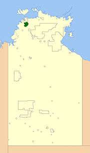 Location of the Coomalie Shire | |||||||||||||
| Population | 1,296 (2015 est)[1] | ||||||||||||
| • Density | 0.864/km2 (2.24/sq mi) | ||||||||||||
| Established | 1990 | ||||||||||||
| Area | 1,500 km2 (579.2 sq mi) | ||||||||||||
| Mayor | Wendy Leach | ||||||||||||
| Council seat | Batchelor | ||||||||||||
| Region | outer Darwin | ||||||||||||
| Territory electorate(s) | Daly | ||||||||||||
| Federal Division(s) | Lingiari | ||||||||||||
| Website | Coomalie Shire | ||||||||||||
| |||||||||||||
The Coomalie Shire is a local government area in Australia's Northern Territory, situated south of Darwin and Palmerston. The council governs an area of 1,500 km2 (580 sq mi). The shire had a population of 1,106 at the 2011 census.[2]
History
Coomalie Community Government Council was established on 7 December 1990, and its first elections were held in 1997. On 1 July 2008, Coomalie Council became one of the 11 Shires in the territory, changed by the Northern Territory Government.
Wards
The council is divided up into six wards, which is governed by 9 councillors across the six wards:
- Batchelor Township Ward (3) (Batchelor)
- Adelaide River Township Ward (2) (Adelaide River)
- Batchelor Rural Ward (1)
- Adelaide River Rural Ward (1)
- Lake Bennett Ward (1) (Lake Bennett)
- Coomalie/Tortilla Ward (1)
Townships
The Shire includes the localities of
- Batchelor
- Adelaide River
- Coomalie Creek
- Rum Jungle
The boundary of this area extends from the Manton Dam in the north, to the town of Adelaide River in the south and east from the Adelaide River, to the Litchfield National Park in the west.
Meetings
Meetings are scheduled for the 3rd Tuesday of every month.
See also
References
- ↑ "3218.0 – Regional Population Growth, Australia, 2014–15". Australian Bureau of Statistics. Retrieved 29 September 2016.
- ↑ Australian Bureau of Statistics (28 March 2013). "2011 Census QuickStats". Retrieved 26 July 2014.
External links
Coordinates: 13°04′S 131°01′E / 13.067°S 131.017°E