Continental Chile
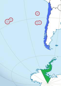
In blue: Continental Chile
In red: Insular Chile
In green: Antarctic Chile
Continental Chile is the name given to the Chilean territory located on the continental shelf of South America. This term serves to distinguish the South American area from the insular territories, known as Insular Chile, as from the Antarctic Chile (Chilean Antarctic Territory). The existence of this three areas of effective or claimed Chilean sovereignty is what supports the existing tricontinental principle in this country.[1][2][3]
In addition, this term allows to specify the time zones in Chile. This way, continental Chile, together with the Juan Fernández archipelago and the Desventuradas Islands, is located in the UTC-3 time zone, while the Easter Island and the Isla Salas y Gómez, both in Polynesia, (UTC-5).
Continental Chile has a surface of 756 770 km², representing 99,976% of the total surface of the country under effective administration. However, considering the claim in Antarctic, this percent fall down to only 37,71% of national's surface.
With regard to the population, according to the 2002 census, it had a total of 15 111 881 inhabitants, corresponding to 99,97% of the national population.
References
- ↑ Icarito. "Chile: un país tricontinental" (in Spanish). Retrieved March 29, 2008.
- ↑ Instituto Geopolítico de Chile. "Principios geopolíticos de Chile" (PDF) (in Spanish). Retrieved March 29, 2008.
- ↑ President of Chile, Ministry General Secretariat of Government (2007). "Geografía nacional: Situación, superficie y extensión" (ASP) (in Spanish). Retrieved November 29, 2007.