Congress Parkway
| 500 South | |
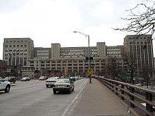 Congress Parkway, heading east, passing under the Old Chicago Main Post Office | |
| Length | 1.12 miles (1.80 km) |
|---|---|
| Location | Chicago |
| From |
|
| To | Columbus Drive in Chicago |
Congress Parkway is a major east-west street in downtown Chicago. It runs east from the Circle Interchange, where it meets Interstates 90, 94, and 290. I-290 ends at Wells Street, and Congress Parkway continues as a surface street past State Street and Michigan Avenue, until ending at Columbus Drive in Grant Park.
Route description
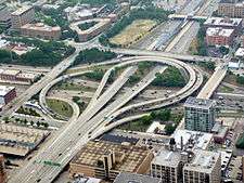
Congress Parkway begins at the Circle Interchange, where it intersects the Kennedy, Dan Ryan, and Eisenhower Expressways. After passing through the interchange, the road passes under Old Chicago Main Post Office, then over the South Branch of the Chicago River. At an interchange with Franklin Street and Wacker Drive, Congress Parkway changes from a freeway to a surface street. It then crosses north-south streets in downtown, including LaSalle Street, Clark Street, State Street, and Michigan Avenue. At Michigan Avenue, Congress Parkway enters Grant Park, where it ends at Columbus Drive, just west of Buckingham Fountain.
History
Congress Parkway was proposed in the 1909 Plan of Chicago as the central axis of the replanned city. Authors Daniel Burnham and Edward H. Bennett proposed a broad new boulevard on the line of Congress Street that would cut through the long blocks between Van Buren and Harrison Streets, connecting a cultural center of new buildings in Grant Park to a new civic center centered on Congress and Halsted Street, then extending westward to parks and suburban areas beyond the city limits. Downtown, Congress was then a two-block-long street, platted in 1848, which ran from State Street east to Michigan Avenue.
In the late 1920s, the U.S. Post Office Department chose a site for Chicago’s main post office that would block any future Congress Parkway. Bennett and the Chicago Plan Commission loudly objected.[1] Finally a compromise was reached that left a passageway through the building, completed in 1933.[2]
As planning for Chicago-area superhighways advanced in the 1920s, a route through the West Side was a high priority. When planners seemed to lean toward a Monroe Street alignment, Bennett published a 1929 study arguing the superiority of Congress Street.[3] After extensive study of alternatives, a Congress Street alignment was included in the city’s 1940 Comprehensive Superhighway Plan.[4]
During the 1930s, Chicago’s plans for rapid transit became intertwined with plans for superhighways. When the Public Works Administration approved a grant for the city’s downtown subways, it was conditioned on construction of the downtown portion of Congress Parkway.[5] Chicago’s “Subway Route No. 2” was being planned for a route under Milwaukee Avenue and Dearborn Street, turning westward under Congress Parkway, with a future extension westward anticipated.
Construction of the downtown section, which began in December 1949, presented several challenges. The new superhighway had to be carried above Clinton and Canal and Streets, through the Post Office at a level similar to surrounding streets, and across the South Branch of the Chicago River on twin drawbridges. East of the river, ramps connected to Franklin Street and two levels of Wacker Drive before the end of controlled access at Wells Street. The platforms of LaSalle Street Station required new supports for creation of an underpass for Congress Parkway. More than two dozen buildings were cleared for the new street, including the 13-story Monon and 12-story Caxton Buildings on Dearborn Street, part of Printer's Row. East of State Street, arcaded sidewalks were cut into existing buildings, including the Auditorium Theater, to allow six lanes of auto traffic.[6] The new street opened for traffic from State Street to LaSalle Street in 1952,[7] with the full length opened August 10, 1956.
A ceremonial stairway into Grant Park was altered to allow the new street to reach Columbus Drive. Plans for ramps under Buckingham Fountain to connect Congress to Lake Shore Drive were never carried out.
Rather than a new central axis for an expanded business district, the wide, heavily trafficked Congress Parkway came to represent the southern boundary of the Loop. Small parcels cleared for construction but not needed for the street itself became gas stations and small parking lots. As Printers Row was redeveloped into residential buildings during the 1970s and 1980s, Congress Parkway came to be seen as a boundary between the office and residential districts.[8]
When Chicago’s new Harold Washington Library opened in 1992 at State Street and Congress Parkway, it turned attention again to Congress Parkway’s role as a civic gateway. A streetscaping project opened in 2013 used lighted median columns and sidewalk trellises to create an “electronic streetscape,” whose changing colors are a reminder of Buckingham Fountain at the street’s eastern end. A 2012 reconstruction of the south end of Wacker Drive added extensive landscaping around and over the ramps that connect with Congress Parkway at Franklin Street.
Before Interstate 290 was named the Dwight D. Eisenhower Expressway, it was called the Congress Expressway, because its eastern end is located at Congress Parkway.
Junction list
The entire route is in Chicago, Cook County. All exits are unnumbered.
| mi[9] | km | Destinations | Notes | ||
|---|---|---|---|---|---|
| Continuation beyond I-90/I-94 | |||||
| 0.00 | 0.00 | Circle interchange | |||
| 0.00 | 0.00 | Circle interchange; no entrance | |||
| 0.05– 0.08 | 0.080– 0.13 | Canal Street | Eastbound exit and westbound entrance | ||
| 0.42 | 0.68 | Wacker Drive, Franklin Street | Eastbound exit and westbound entrance; east end of freeway section | ||
| 1.12 | 1.80 | Columbus Drive | T-intersection; eastern terminus | ||
| 1.000 mi = 1.609 km; 1.000 km = 0.621 mi | |||||
References
- ↑ Joan Draper. Edward H. Bennett, Architect and City Planner. p. 24
- ↑ Chicago Daily Tribune, Dec. 28, 1930
- ↑ Edward H. Bennett and Harry T. Frost. The Axis of Chicago, 1929.
- ↑ Journal of the Western Society of Engineers, Feb. 1941
- ↑ Chicago Daily Tribune, Sept. 17, 1942 p. 5
- ↑ ”Buildings no barrier to Chicago’s Congress Street Superhighway,” Civil Engineering, January 1954, p. 37.
- ↑ City of Chicago Dept. of Subways and Superhighways, Annual Report 1952
- ↑ Creating a Vision for Congress Parkway, Friends of Downtown (Chicago), 2003
- ↑ "Overview of Congress Parkway". Google Maps. Google, Inc. Retrieved August 24, 2016.