Congerville-Thionville
| Congerville-Thionville | |
|---|---|
|
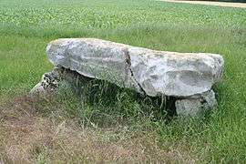
The dolmen of Grès de Linas, in Congerville-Thionville | |
 Congerville-Thionville | |
|
Location within Île-de-France region  Congerville-Thionville | |
| Coordinates: 48°23′14″N 1°59′19″E / 48.3873°N 1.9885°ECoordinates: 48°23′14″N 1°59′19″E / 48.3873°N 1.9885°E | |
| Country | France |
| Region | Île-de-France |
| Department | Essonne |
| Arrondissement | Étampes |
| Canton | Méréville |
| Government | |
| • Mayor (2008–2014) | Thierry Guérin |
| Area1 | 8.47 km2 (3.27 sq mi) |
| Population (2006)2 | 229 |
| • Density | 27/km2 (70/sq mi) |
| Time zone | CET (UTC+1) |
| • Summer (DST) | CEST (UTC+2) |
| INSEE/Postal code | 91613 / 91740 |
| Elevation | 113–151 m (371–495 ft) |
|
1 French Land Register data, which excludes lakes, ponds, glaciers > 1 km² (0.386 sq mi or 247 acres) and river estuaries. 2 Population without double counting: residents of multiple communes (e.g., students and military personnel) only counted once. | |
Congerville-Thionville is a commune in the Essonne department in Île-de-France in northern France.
Inhabitants of Congerville-Thionville are known as Congervillois-Thionvillois.
See also
References
- INSEE
- Mayors of Essonne Association (French)
External links
| Wikimedia Commons has media related to Congerville-Thionville. |
- Mérimée database - Cultural heritage (French)
- Land use (IAURIF) (English)
This article is issued from Wikipedia - version of the 2/10/2016. The text is available under the Creative Commons Attribution/Share Alike but additional terms may apply for the media files.