Comodoro Rivadavia
| Comodoro Rivadavia | ||
|---|---|---|
|
Downtown Comodoro Rivadavia | ||
| ||
| Nickname(s): The Capital of the Wind | ||
| Motto: A city with energy. | ||
 Comodoro Rivadavia | ||
| Coordinates: AR 45°51′53″S 67°28′51″W / 45.86472°S 67.48083°W | ||
| Country |
| |
| Province |
| |
| Department | Escalante Department | |
| Founded | 1901 | |
| Government | ||
| • Mayor | Néstor di Pierro | |
| Area | ||
| • Total | 548.2 km2 (211.7 sq mi) | |
| Elevation | 61 m (200 ft) | |
| Population (2010[1]) | ||
| • Total | 182,631 | |
| • Density | 330/km2 (860/sq mi) | |
| Time zone | GMT (UTC-3) | |
| Post code | 9000 | |
| Climate | BSk | |
| Website | Official Website | |
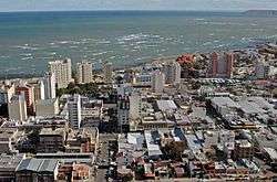

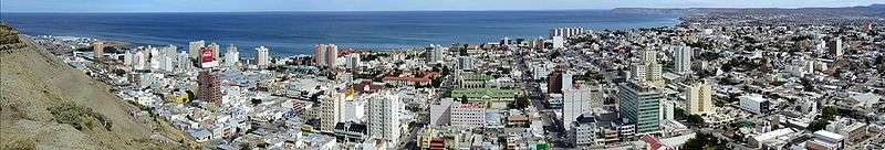
Comodoro Rivadavia (Spanish pronunciation: [komoˈðoɾo riβaˈðaβja]) is a city in the Patagonian province of Chubut in southern Argentina, located on the San Jorge Gulf, an inlet of the Atlantic Ocean, at the foot of the Chenque Hill. Comodoro Rivadavia is the most important city of the San Jorge Basin .
The city is often referred simply as Comodoro. It was at one time the capital of Comodoro Rivadavia Territory, which existed from 1943 to 1955. The territory was a part of Chubut before and after its creation, and the city became the capital of Escalante Department. It had a population of 137,061 at the 2001 census [INDEC], and grew to 182,631 by the 2010 census.[1]
Comodoro Rivadavia is a commercial and transportation center for the surrounding region, the largest city of Chubut, and an important export point for a leading Argentine petroleum district. A 1,770 km pipeline conveys natural gas from Comodoro Rivadavia to Buenos Aires.
Founded by decree on February 23, 1901, as a port for the inland settlement of Sarmiento, the first settler was Francisco Pietrobelli. Early settlers included Boers escaping British rule in South Africa, as well as Welsh settlers.
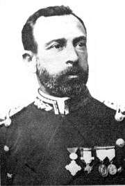
The town was named in honour of shipping minister Martín Rivadavia, a proponent of the development of Southern Argentina. It has been prosperous since 1907, when a drilling crew searching for water struck oil at a depth of 539 m.
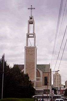
The city is the home of the main faculty of the National University of Patagonia San Juan Bosco. The Cathedral is the seat of the Diocese of Comodoro Rivadavia, of which the Bishop is, since 2005, Virginio Domingo Bressanelli. The Cathedral is dedicated to San Juan Bosco, the only cathedral in the world dedicated to the founder of the Salesian Order. It was inaugurated in 1979, although the crypt itself had been dedicated in 1949.
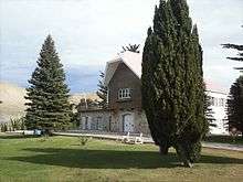
Rada Tilly is a beach resort and now suburb 12 km south of Comodoro. The National Museum of Petroleum is located in the General Mosconi neighbourhood 3 km north of central Comodoro Rivadavia. It was opened in 1987 by the state-owned oil company YPF.
Comodoro Rivadavia is served by General Enrique Mosconi International Airport (Airport Code CRD/SAVC) with daily flights to Buenos Aires and many other Patagonian cities, as it is the main hub of LADE.
History
The urgency to define short routes to transport products from Colonia Sarmiento and bring them to that village created the necessity of a port in the area of San Jorge Gulf. This necessity made possible the foundation of Comodoro Rivadavia, today capital of petroleum in Argentina. The first governor of Gobernación Nacional del Chubut was Colonel Luis Jorge Fontana, who traveled around the whole extension attributed to Chubut commanding a numerous group of Welsh immigrants in 1885. American researcher Junius Bird and Finnish geographer Väinö Auer confirmed the existence of a Tehuelche prototype who lived in the sands of Rada Tilly some 9000 years ago. This information was confirmed by Father Brea, who some years ago contributed to this theory with the discovery of utensils and human remains near Rada Tilly.
It is widely known that the Tehuelche who came from the north of Patagonia during warm summer days used to make a halt where Rada Tilly is today. The English navigator FitzRoy was the first to mention its existence in a navigation chart.
On March 10, 1889, Francisco Pietrobelli, accompanied by the Tehuelche Sainajo and Marcelo Pereira, came to Rada Tilly following FitzRoy's navigation charts in search of an anchoring place to set up a deep-water port where deep-draft ships could stop to supply the flourishing Colonia Sarmiento.
The corvette La Argentina, commanded by Commodore Martín Rivadavia, arrived near Mount Chenque in an exploratory mission and settled an anchorage place now called Kilometro 5, Caleta Córdova or Punta Borjas. Pietrobelli completed the construction of the first storage shed on June 26 in the place indicated years before by a Molle trunk. Commodore Rivadavia became the first Argentine marine to anchor his corvette in Rada Tilly in March 1891, while he was reconnoiteirng the area to control the displacement of the Chilean Army in the Argentine south. The village was named after the Spanish marine Francisco Everardo Tilly y Paredes, who during 1794 and 1795 gave combat and defeated the Portuguese army in the river Plate. However, reality indicates that it was the Spanish marine Juan de la Concha who anchored in Rada Tilly in command of a brig.
The settlement was renamed Comodoro Rivadavia on February 23, 1901, by decree of the national government in homage to the illustrious marine, grandson of the great statesman Bernardino Rivadavia and first Argentine president.
Discovery of oil
In 1903 six hundred Afrikaner families arrived in Argentina following the loss of the Second Boer War. They were given farming land in the lands around Comodoro Rivadavia but due to a shortage of water had to bring water in by ox wagon. The lack of water was a big impediment to the development of the settlement. At the Afrikaners' insistence drilling began in 1907 in an effort to look for water but instead they struck oil. Although much of the oil was discovered on land given to Afrikaans settlers, they could not benefit directly from the discovery due to Argentinian law which decrees that all mineral deposits belong to the state. Therefore, most of the town's Afrikaans settlers moved on to Sarmiento and surrounding regions to set up farms there.[2]
The discovery of oil in 1907 boosted economic growth in Comodoro Rivadavia. By the end of 1919, most of the 1719 workers were given accommodation in small metal sheet houses without any heating or electric light with temperatures below zero and winds near 100 km/h. The establishment of Yacimientos Petrolíferos Fiscales (YPF) in 1922 led to the development of the town, further accelerated afterand the end of the 1950s by President Arturo Frondizi's oil campaign to foster the installation of numerous foreign companies. The city evolved around this industry, and even today when this panorama has changed substantially, it is still called the "National Oil Capital."
The beach village Rada Tilly was founded on July 24, 1948, and today is an important hub for tourism in Argentina. Oil production has begun to decline in quantity but the area has been turning its attention to wind power. Windmills on Cerro Chenque and surrounding hills comprise South America's largest wind farm and provide 20% of Comodoro's energy needs. Mayor Martín Buzzi was elected Governor of Chubut Province in 2011.
Climate
Comodoro Rivadavia features a cold semi-arid climate (Köppen BSk). While the city receives less than 250 mm of rain annually, its relatively low evapotranspiration rate causes it to fall under this climate category. Summer is relatively hot and dry with an average temperature of 19.9 °C (67.8 °F) in January.[3] Winter is mild with an average temperature of 6.8 °C (44.2 °F) in July.[3] Precipitation is low, though the winter months receive more precipitation than in summer.
- Average temperatures: Annual 12.8 °C
- Maximum Average: January 25.6 °C
- Minimum Average: July 2.8 °C
- Predominant winds: W, SW
- Precipitations: Average annual 238.7 mm
- Month of Maximum Precipitations: May
- Fog: 4 days/year
| Climate data for Comodoro Rivadavia (General Enrique Mosconi International Airport) 1961–1990, extremes 1931–present | |||||||||||||
|---|---|---|---|---|---|---|---|---|---|---|---|---|---|
| Month | Jan | Feb | Mar | Apr | May | Jun | Jul | Aug | Sep | Oct | Nov | Dec | Year |
| Record high °C (°F) | 40.2 (104.4) |
39.5 (103.1) |
39.2 (102.6) |
31.6 (88.9) |
26.3 (79.3) |
22.6 (72.7) |
22.8 (73) |
24.7 (76.5) |
29.7 (85.5) |
32.0 (89.6) |
35.5 (95.9) |
38.6 (101.5) |
40.2 (104.4) |
| Average high °C (°F) | 25.6 (78.1) |
24.8 (76.6) |
22.2 (72) |
18.5 (65.3) |
14.1 (57.4) |
10.9 (51.6) |
10.5 (50.9) |
12.4 (54.3) |
15.4 (59.7) |
18.6 (65.5) |
22.1 (71.8) |
24.2 (75.6) |
18.3 (64.9) |
| Daily mean °C (°F) | 19.1 (66.4) |
18.4 (65.1) |
16.1 (61) |
12.9 (55.2) |
9.5 (49.1) |
6.8 (44.2) |
6.4 (43.5) |
7.7 (45.9) |
9.9 (49.8) |
12.7 (54.9) |
15.9 (60.6) |
17.9 (64.2) |
12.8 (55) |
| Average low °C (°F) | 13.2 (55.8) |
12.7 (54.9) |
10.9 (51.6) |
8.4 (47.1) |
5.6 (42.1) |
3.1 (37.6) |
2.8 (37) |
3.6 (38.5) |
5.1 (41.2) |
7.2 (45) |
10.1 (50.2) |
11.9 (53.4) |
7.9 (46.2) |
| Record low °C (°F) | 3.9 (39) |
2.6 (36.7) |
0.3 (32.5) |
−4.1 (24.6) |
−4.9 (23.2) |
−8.5 (16.7) |
−7.6 (18.3) |
−5.4 (22.3) |
−5.7 (21.7) |
−1.8 (28.8) |
0.2 (32.4) |
2.0 (35.6) |
−8.5 (16.7) |
| Average precipitation mm (inches) | 16.2 (0.638) |
15.0 (0.591) |
20.7 (0.815) |
23.3 (0.917) |
31.7 (1.248) |
25.3 (0.996) |
28.7 (1.13) |
25.0 (0.984) |
12.3 (0.484) |
14.9 (0.587) |
10.6 (0.417) |
15.0 (0.591) |
238.7 (9.398) |
| Average precipitation days (≥ 0.1 mm) | 4 | 4 | 4 | 5 | 7 | 6 | 6 | 6 | 5 | 5 | 4 | 5 | 61 |
| Average snowy days | 0 | 0 | 0 | 0 | 0.2 | 2 | 2 | 0.7 | 0.6 | 0 | 0 | 0 | 5.5 |
| Average relative humidity (%) | 40 | 43 | 47 | 50 | 59 | 61 | 60 | 56 | 51 | 47 | 42 | 40 | 50 |
| Mean monthly sunshine hours | 241.8 | 218.4 | 182.9 | 147.0 | 127.1 | 114.0 | 114.7 | 136.4 | 150.0 | 195.3 | 234.0 | 235.6 | 2,097.2 |
| Percent possible sunshine | 51 | 55 | 47 | 45 | 43 | 43 | 41 | 42 | 42 | 47 | 53 | 49 | 47 |
| Source #1: NOAA,[4] Meteo Climat (record highs and lows)[5] Secretaria de Mineria (November record high, and April, May, July, and August record lows only),[6] | |||||||||||||
| Source #2: Servicio Meteorológico Nacional (precipitation days),[7] UNLP (snowfall data)[8] | |||||||||||||
Population
Comodoro Rivadavia had a population of 182,631 inhabitants in 2010, compared to 135,632 in 2001 and 124,104 in 1991. The city grew by about a third between 2001 and 2010, compared to an increase of 9.2% between 1991 and 2001; the national average was of around 11% in both periods, representing a notable acceleration in population growth for the city in comparison to Argentina.[1] The city size places Comodoro Rivadavia as the 20th largest city of the country and the largest in South Patagonia, which goes from Chubut to Tierra del Fuego.
Urban Areas
Comodoro Rivadavia is the biggest city to the south of the Colorado River. The city developed from the oil camps which evolved into neighbourhoods.
The city is divided into three main areas: North Area, South Area and Downtown Area.
The South Area is the most populated in the city. The neighbourhoods are: Jorge Newbery, San Martin, 1311 Viviendas, Cerro Solo, Ñaco, San Cayetano, Francisco Pietrobelli, Las Flores, La Floresta, Máximo Abasolo .
Moure, Cordón Forestal, Quirno Costa, Maestro Isidro Quiroga, Juan XIII, San Isidro Labrador, 9 de Julio, 13 de Diciembre, Julio A. Roca, Juan Manuel de Pueyrredon, 30 de Octubre, LU4, Abel Amaya, Industrial, Stella Maris, Ceferino Namuncurá, Jose Fuchs, Balcón del Paraiso, Covipex, Rincón del Diablo, 311 Viviendas and Humberto Beghin.
The Downtown area divided into: Centro, Loma and Civico neighbourhood.

The Northern Area divided into:
- 3rd Kilometre
- 4th Kilometre, home of National University of Patagonia San Juan Bosco.
- 5th Kilometre.
- 6th Kilometre, home of General Enrique Mosconi International Airport) and Petroleros Privados.
- 8th Kilometre.
Economy
Industry and Commerce
The commercial and industrial activities of the city are the most important in the region. The main activities of the city are: production of chemical products, elaborated concrete, salter, fabrication of industrial houses, shipyard, metallurgical products, refrigerated products, industrial factories, casting, textile industry, blocks and bricks, and cement.
Oil Industry
The oil production started in Chubut in 1907, when a drilling rig which was looking for water discovered oil instead. The Argentine oil industry started in Comodoro Rivadavia, and was facilitated by the 1886 National Mining Code (Codigo de Mineria de la Nación). This code established that the oil fields belonged to the State, and that they could also be exploited by the private sector by concession.
In 1922 YPF (Yacimientos Petrolíferos Fiscales), the first state-owned oil company in the world, was created by President Hipólito Yrigoyen's government. This company helped the society by improving the construction of houses, providing new jobs and health care. Engineer Enrique Mosconi was in charge of running the company. By 1933, 1,648 wells had been drilled in Comodoro Rivadavia; 88.9% of them were economically productive.
In 1935 the First Oil Law was passed. It established that the National and provincial States would receive as contribution the 12% of the Gross Product from all oil drilling, which is still in effect.
In 1958, Law Number 14,773 was signed by President Arturo Frondizi, establishing that the Government had exclusive ownership over all oil fields.
The most important oil fields discovered during the 60's were El Huemul and Piedra Clavada. At the beginning of the same decade twenty wells were drilled.
Between 1977 and 1986, 100 million m³ oil were drilled from San Jorge gulf, in the meantime the oil reserves reached 40 million m³; in 1979 the San Jorge gulf production reached 10,124,022 m³ of oil.
Until 2001, 5,300 wells were drilled, of which 3,000 were economically productive. As a result of the exploratory activities developed during the century, the remaining reserves reach 182.017 million m³ of oil. San Jorge gulf is the leader in oil extraction. 46,000 m³ per day are extracted in the zone, representing 46% of total crude oil production in the nation.
Geography of Comodoro Rivadavia

Comodoro Rivadavia is situated in the south of Argentina in the province of Chubut, on the coast of San Jorge Gulf.
It was necessary to create a port in the area of San Jorge Gulf in order to have shorter routes for transporting products from and to the town of Sarmiento, situated 180 km away from the city of Comodoro Rivadavia.
Information for Navigation
Geographic location:
Comodoro Rivadavia: Latitude 45° 51´ S; Longitude 67° 28´ W. Caleta Olivia: Latitude 45° 46´ S; Longitude 67° 22´ W. Caleta Córdova: Latitude 45° 43´ S; Longitude 67°31´ W. Time zone: GMT -3
Nautical information:
Argentine map course: Part 2. Cartography S.H.N. Letters N ° 30.75 H314 and H310.
Foundation and History of the Port

History of Comodoro Rivadavia Port
Since 1908, the small and weak port Maciel received passengers and shipments that arrived at the city of Comodoro Rivadavia. It was built of wood and only could support small ships. In 1923, the construction of the port started. In 1926 the construction was stopped, but in 1928 it was resumed.
Port Facilities
Comodoro Rivadavia’s port is the most complete port of Patagonia. The transportation of regional commodities, is the most important activity connected with the ocean to ocean corrirdor.
National Route 3 runs along the east coast and the National Road Number 26 connects the city with Chile, to the West. This becomes an important communication line connectig east and west, or the Atlantic with the Pacific Ocean and it is made mostly by paved roads.
The ocean to ocean corridor is fundamental for commerce, tourism and passengers circulation. It joins, in less than 600 km and a few hours of traveling, Chacabuco Port in the Pacific Ocean with the Comodoro Rivadavia Port in the Atlantic Ocean.
There is a border pass called “Hito 50” or Paso Huemules (480 meters above sea level) which can be used all year round because it is not affected by the winter snow, due to its lower position.
This route has an enormous relevance because it links communities, integrates and projects two countries promoting the regional growth.
The port has a shipyard in a privileged area. The shipyard has two parallel industrial facilities of 70 meters long and 4 meters wide. This allows the repair and building of ships in a roofed space without the weather affecting the activity.
The shipyard has three travelling cranes of 8 tons each. Works made in the shipyard include the building of eolic mill towers and oil buoys.
The port facilities include:
• The principal Port situated near the downtown. Its extreme point called Punta Borja, was designed to receive ships up to 181 meters length and 10 meters depth.
The port has a pier of 216 meters long, which was built to meet the demand of the transportation of commodities, deep-sea fishing and naval repairs.
• Caleta Cordova's low tide pier is located in the north of Comodoro Rivadavia city, over the coast of Caleta Cordova’s neighborhood. This pier meets the demand of artisan fishing.
• Repsol-YPF's pier, located in the south of General Mosconi neighbourhood, is used for unloading fuel. The total fuel unloaded is over 29,000 liters per month.
• Caleta Olivares's facilities are used to load crude oil. It has four mooring buoys and one bell buoy. The depth of this area is 9 meters.
• Caleta Cordova's facilities for loading crude oil include one charge buoy and four mooring buoys. These facilities located 5 kilometres (3.1 mi) away from the coast are used for mooring ships up to 100.000 tons and 11 meters depth.
.JPG)
Production of Concrete
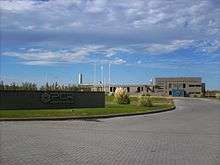
The city also is home to a factory that produces concrete, property of Petroquimica Comodoro Rivadavia S.A. It produces different types of concrete: Standard Portland, Puzolanic, BCA, ARI, bricklaying concrete Caltex, concrete for oil industry. The total production of concrete for the year 2002 was 228,000 tons.
Eolic Energy
The wind farm of Comodoro Rivadavia has a capacity of 18,820 kW with 26 generators, and is the most important in Latin America. Plans exist to connection it the national energy, which could allow the sale of energy to other regions.
Illegal Fishing
In order to avoid the increase of illegal fishing of squid in Comodoro Rivadavia's Port, the provincial government and SENASA (government organization that controls food quality) have produced a regulation which organize and control the procedure for international transportation of fish.
The ships with flags different from the Argentinian, are allowed to fish in waters further than the continental platform; and the provincial government allows them to load their shipments, collect them in containers and move them by routes towards other cities where commercial ships will take the squid to export destinations.
It is not allowed to foreign fishers to sell what they have captured neither negotiate with processing plants in the city of Comodoro Rivadavia or any other city in the region, because this might have a negative impact on the local economy.
Sports
The most important sports in the city of Comodoro Rivadavia are basketball, football (soccer) and car racing, among others such as land yachting, judo, rugby and athletics.
One of the most representative sports is basketball. Comodoro Rivadavia is the home of the most important basketball team of the region and 2006 National League champion, Gimnasia y Esgrima (Comodoro Rivadavia) also called "The Green Magic". The club it is not only formed by local players; the members are from all over the world. Other important basketball clubs are Nautico and Federacion Deportiva.

The other important sport is football (soccer). The most popular clubs are CAI (Comisión de Actividades Infantiles), which is ranked in the B National League of football, Huracán de Comodoro Rivadavia, which plays in the Argentine Tournament "B" and Club Atlético Jorge Newbery "El Aeronauta".
Comodoro Rivadavia also has a football league in which many teams participate; the principal teams are Jorge Newbery, Huracán and Petroquímica. There are other clubs such as Tiro Federal, Universitario, Ferroviario, Usma, Tiro Federal and Portugues, which are located in the First A League of Comodoro Rivadavia. Although they are not as prestigious, they are a huge part of the culture and the entertainment of the city. Each of these clubs has their own football court on different neighbourhoods.
Land yachting has become very popular in the city and the beaches of Rada Tilly, together with the windy climate, are ideal to practise the sport. The sport started in Argentina in the 1960s. Rada Tilly Village is the best place in the country to practice this sport, at any time of the year.
This sport consists of a three-wheeled car and a sail similar to the one that is used to practice windsurfing. The speed can reach 180 km per hour that is why it’s important to have an excellent ability to manage the car. Pablo Reyes is one of the most important pilots, and he was the first one to get on a car built and designed by himself. The World Championship of Landyachting was held in 2008 in Rada Tilly.
References
- 1 2 3 "Censo 2010: Provincia del Chubut por departamento". INDEC.
- ↑ Hunt, Ricky (4 February 2011). "The last Boers of Patagonia". Mail & Guardian. Retrieved 6 February 2011.
- 1 2 "Comodoro Rivadavia Statistical Data (1981-1990)" (in Spanish). National Meteorological Service of Argentina. Retrieved 29 July 2013.
- ↑ "COMODORO RIVADAVIA AERO Climate Normals 1961–1990". National Oceanic and Atmospheric Administration. Retrieved 1 April 2015.
- ↑ "Station Comodoro Rivadavia" (in French). Meteo Climat. Retrieved June 11, 2016.
- ↑ "Provincia de Chubut - Clima Y Meteorologia: Datos Meteorologicos Y Pluviometicos" (in Spanish). Secretaria de Mineria de la Nacion (Argentina). Archived from the original on January 19, 2015. Retrieved 1 April 2015.
- ↑ "Valores Medios de Temperature y Precipitación-Chubut: Comodoro Rivadavia" (in Spanish). Servicio Meteorológico Nacional. Retrieved 1 April 2015.
- ↑ "Datos bioclimáticos de 173 localidades argentinas". Atlas Bioclimáticos (in Spanish). Universidad Nacional de La Plata. Retrieved 4 July 2016.
External links
- (Spanish) Municipality of Comodoro Rivadavia - Official website.
- (Spanish) History of Comodoro Rivadavia.
- (Spanish) Photos, Pictures of the city
- Municipal information: Municipal Affairs Federal Institute (IFAM), Municipal Affairs Secretariat, Ministry of Interior, Argentina. (Spanish)
| Champion drivers |
|
|---|---|
| Cars | |
| Current circuits (2012) | |
| Former circuits | |