Colwyn, Pennsylvania
| Colwyn, Pennsylvania | |
| Borough | |
 Colwyn Elementary School | |
| Country | United States |
|---|---|
| State | Pennsylvania |
| County | Delaware |
| Elevation | 59 ft (18.0 m) |
| Coordinates | 39°54′47″N 75°15′12″W / 39.91306°N 75.25333°WCoordinates: 39°54′47″N 75°15′12″W / 39.91306°N 75.25333°W |
| Area | 0.3 sq mi (0.8 km2) |
| - land | 0.3 sq mi (1 km2) |
| - water | 0.0 sq mi (0 km2), 0% |
| Population | 2,546 (2010) |
| Density | 8,486.7/sq mi (3,276.7/km2) |
| Mayor | Michael Blue |
| Timezone | EST (UTC-5) |
| - summer (DST) | EDT (UTC-4) |
| Area code | 610 |
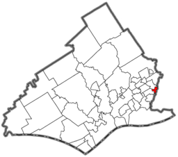 Location of Colwyn in Delaware County
| |
 Location of Colwyn in Pennsylvania
| |
 Location of Pennsylvania in the United States
| |
| Website: www | |
Colwyn is a borough in Delaware County, Pennsylvania, United States. The population was 2,546 at the 2010 census.[1]
Geography
Colwyn is located along the eastern border of Delaware County at 39°54′47″N 75°15′12″W / 39.91306°N 75.25333°W (39.913062, -75.253409),[2] where Darby Creek and Cobbs Creek intersect. It is bordered to the north by the borough of Darby, to the west across Darby Creek by the borough of Sharon Hill, to the south across Cobbs Creek by a small portion of Darby Township, and to the east across Cobbs Creek by the city of Philadelphia.
The Darby station on the SEPTA Wilmington/Newark Line is on Pine Street in Darby, just west of the Colwyn border.
According to the United States Census Bureau, the borough has a total area of 0.26 square miles (0.67 km2), all of it land.[1]
Demographics
| Historical population | |||
|---|---|---|---|
| Census | Pop. | %± | |
| 1900 | 1,226 | — | |
| 1910 | 1,584 | 29.2% | |
| 1920 | 1,859 | 17.4% | |
| 1930 | 2,064 | 11.0% | |
| 1940 | 2,202 | 6.7% | |
| 1950 | 2,143 | −2.7% | |
| 1960 | 3,074 | 43.4% | |
| 1970 | 3,169 | 3.1% | |
| 1980 | 2,841 | −10.4% | |
| 1990 | 2,613 | −8.0% | |
| 2000 | 2,453 | −6.1% | |
| 2010 | 2,546 | 3.8% | |
| Est. 2015 | 2,553 | [3] | 0.3% |
| Sources:[4][5][6] | |||
As of the census[5] of 2000, there were 2,453 people, 850 households, and 602 families residing in the borough. The population density was 9,600.3 people per square mile (3,642.7/km²). There were 954 housing units at an average density of 3,733.7 per square mile (1,416.7/km²). The racial makeup of the borough was 42.64% White, 52.14% African American, 0.12% Native American, 0.98% Asian, 0.69% from other races, and 3.42% from two or more races. Hispanic or Latino of any race were 1.63% of the population.
There were 850 households, out of which 40.2% had children under the age of 18 living with them, 37.8% were married couples living together, 26.7% had a female householder with no husband present, and 29.1% were non-families. 24.6% of all households were made up of individuals, and 7.9% had someone living alone who was 65 years of age or older. The average household size was 2.89 and the average family size was 3.43.
In the borough the population was spread out, with 33.2% under the age of 18, 9.3% from 18 to 24, 30.9% from 25 to 44, 16.8% from 45 to 64, and 9.8% who were 65 years of age or older. The median age was 31 years. For every 100 females there were 90.0 males. For every 100 females age 18 and over, there were 82.5 males.
The median income for a household in the borough was $33,150, and the median income for a family was $39,861. Males had a median income of $33,125 versus $25,880 for females. The per capita income for the borough was $13,883. About 15.7% of families and 16.6% of the population were below the poverty line, including 23.1% of those under age 18 and 13.2% of those age 65 or over.
Budgetary disarray
The borough government is in financial difficulty. In May 2015, it was declared to be "financially distressed" by the state. With an annual budget of about two million dollars, the borough is more than one million dollars in debt.
The local district attorney has seized financial records, although at least some from 2011, 2012, and 2013 cannot be accounted for.[7]
The local tax rate is very high; press reports indicate it to be five times higher than in richer regional towns. No new buildings have been built in Colwyn since 2007.[8]
Education
William Penn School District serves Colwyn.
- Colwyn Elementary School (K-6)
- Penn Wood Middle School (7-8) (Darby)
- Penn Wood High School, Cypress Street Campus (9-10) (Yeadon)
- Penn Wood High School, Green Ave Campus (11-12) (Lansdowne)
 Borough Hall
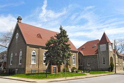 New Life Baptist Church
References
- 1 2 "Geographic Identifiers: 2010 Demographic Profile Data (G001): Colwyn borough, Pennsylvania". U.S. Census Bureau, American Factfinder. Retrieved December 23, 2015.
- ↑ "US Gazetteer files: 2010, 2000, and 1990". United States Census Bureau. 2011-02-12. Retrieved 2011-04-23.
- ↑ "Annual Estimates of the Resident Population for Incorporated Places: April 1, 2010 to July 1, 2015". Retrieved July 2, 2016.
- ↑ "Census of Population and Housing". U.S. Census Bureau. Archived from the original on 22 April 2013. Retrieved 11 December 2013.
- 1 2 "American FactFinder". United States Census Bureau. Archived from the original on 2013-09-11. Retrieved 2008-01-31.
- ↑ "Incorporated Places and Minor Civil Divisions Datasets: Subcounty Resident Population Estimates: April 1, 2010 to July 1, 2012". Population Estimates. U.S. Census Bureau. Archived from the original on 17 June 2013. Retrieved 11 December 2013.
- ↑ McCabe, Caitlin (6 May 2015). "It's official: Troubled Delco town 'distressed'". Philadelphia Inquirer. Retrieved 7 May 2015.
- ↑ McCabe (25 May 2015). "Colwyn: Can this town be saved?". Philadelphia Daily News. Retrieved 26 May 2015.
External links
| Wikimedia Commons has media related to Colwyn, Pennsylvania. |
| Preceded by Darby Township |
Bordering communities of Philadelphia |
Succeeded by Darby |
Municipalities and communities of Delaware County, Pennsylvania, United States | ||
|---|---|---|
| City | 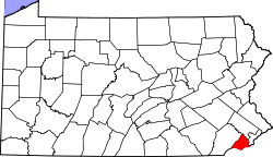 | |
| Boroughs | ||
| Townships | ||
| CDPs | ||
| Unincorporated communities |
| |
| Footnotes | ‡This populated place also has portions in an adjacent county or counties | |