Colstons Almshouses
| Colstons Almshouses | |
|---|---|
 Colstons Almshouses | |
 Location within Bristol | |
| General information | |
| Town or city | Bristol |
| Country | England |
| Coordinates | 51°27′30″N 2°36′00″W / 51.458256°N 2.599926°W |
| Completed | 1691 |
| Client | Edward Colston |
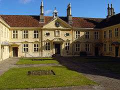
Colstons Almshouses is a historic building on St Michaels Hill, Bristol, England. It was built in 1691 and has been designated by Historic England as a grade I listed building.[1][2] The front wall and gates are also grade I listed.[3]
The almshouses were founded by Edward Colston for 12 inmates.[4] They were expected to attend the chapel twice a day for a prayer reading.[5] The baroque chapel contains panels made from ships timbers and has a barrel vault roof.[2] On the front wall of the chapel is a plaque to Colston.[5]
It is a two-storey limestone building with hipped roofs with triangular canopies over the individual front doors.[5] The building is U shaped, arranged around a courtyard with a all forming the front of the complex.[2] The windows are divided by stone mullions and transoms.[5] There is a central bell cupola.[2]
The building was renovated in 1988.[6] The home provides 12 1-bedroom flats, laundry and communal lounge and a garden. The Society of Merchant Venturers is the trustee for the Almshouses.[7]
Archives
Records of Colston's Almshouses are held at Bristol Archives (Ref. SMV/4/2) (online catalogue).
See also
References
- ↑ "Colstons Almshouses". Images of England. Retrieved 2007-03-16.
- 1 2 3 4 "Colstons Almshouses". National Heritage List for England. Historic England. Retrieved 23 October 2016.
- ↑ "Front wall and gates to Colston's Almshouses". Images of England. Retrieved 2007-03-16.
- ↑ Burrough, THB (1970). Bristol. London: Studio Vista. ISBN 0-289-79804-3.
- 1 2 3 4 "Colston's Almshouses and Chapel". Bristol Opening Doors. Retrieved 23 October 2016.
- ↑ "Colston's Almshouses". Housing Care. Retrieved 23 October 2016.
- ↑ "Care for Older People". Society of Merchant Venturers. Retrieved 8 August 2016.
Coordinates: 51°27′28″N 2°35′55″W / 51.45778°N 2.59861°W