Colorado State Highway 41
| ||||
|---|---|---|---|---|
|
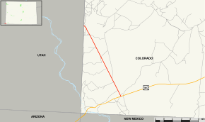
Map of Montezuma County in southwestern Colorado with SH 41 highlighted in red | ||||
| Route information | ||||
| Maintained by CDOT | ||||
| Length: | 9.505 mi[1] (15.297 km) | |||
| Major junctions | ||||
| From: |
| |||
| To: |
| |||
| Location | ||||
| Counties: | Montezuma | |||
| Highway system | ||||
|
Colorado State Highways
| ||||

State Highway 41 (SH 41) is a state highway on the Ute Mountain Ute lands in southwest Colorado, United States. It runs through the valley of the San Juan River, heading northwest from U.S. Highway 160 northeast of the Four Corners Monument. SH 41 ends at the Utah state line, where the road continues as State Route 162 to Bluff. The road is part of the Trail of the Ancients National Scenic Byway.
History
State Highway 41 was created in 1965-1966 on new alignment.[2] Simultaneously, in June 1965, Utah State Route 262 was extended southeast from Montezuma Creek to meet SH 41 (this extension became SR-162 in 2004).[3]
Major intersections
The entire route is in Montezuma County.
| Location | mi | km | Destinations | Notes | |
|---|---|---|---|---|---|
| | 0.000 | 0.000 | Southern terminus | ||
| | 9.505 | 15.297 | Utah state line | ||
| 1.000 mi = 1.609 km; 1.000 km = 0.621 mi | |||||
References
- ↑ Colorado Department of Transportation, Highway Data Explorer, accessed November 2013
- ↑ Colorado Department of Transportation, official highway maps: 1965, 1966
- ↑ Utah Department of Transportation, Highway Resolutions: Route 262, updated December 2008, accessed November 2013
External links
This article is issued from Wikipedia - version of the 2/5/2016. The text is available under the Creative Commons Attribution/Share Alike but additional terms may apply for the media files.