Colorado State Highway 145
| ||||
|---|---|---|---|---|
|
Map of southwestern Colorado with SH 145 highlighted in red | ||||
| Route information | ||||
| Maintained by CDOT | ||||
| Length: | 116.1 mi[1] (186.8 km) | |||
| Major junctions | ||||
| South end: |
| |||
|
| ||||
| North end: |
| |||
| Highway system | ||||
|
Colorado State Highways
| ||||

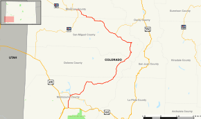
State Highway 145 (SH 145) is a 116.1 mi (186.8 km) long state highway in western Colorado.
Route description

Lizard Head Peak along SH 145
The route begins in the south at its intersection with U.S. Highway 160 in the eastern portion of the city of Cortez. The route winds northward through the towns of Dolores, Rico, Sawpit, Placerville, Norwood, and Redvale before terminating at the junction with State Highway 141 about four miles (6 km) east of Naturita. Just north of its midpoint between Rico and Sawpit, the road also passes very near and provides access to the town of Telluride.
Major intersections
| County | Location | mi[1] | km | Destinations | Notes | |||
|---|---|---|---|---|---|---|---|---|
| Montezuma | Cortez | 0.000 | 0.000 | South end of route | ||||
| | 7.864 | 12.656 | South end of SH 184 overlap | |||||
| | 8.729 | 14.048 | North end of SH 184 overlap | |||||
| Dolores |
No major junctions | |||||||
| San Miguel | Placerville | 84.289 | 135.650 | |||||
| Montrose | | 116.879 | 188.099 | North end of route | ||||
1.000 mi = 1.609 km; 1.000 km = 0.621 mi
| ||||||||
References
- 1 2 "Segment Descriptions for Highway 145". Colorado Department of Transportation. Retrieved 2008-03-25.
External links
This article is issued from Wikipedia - version of the 7/9/2016. The text is available under the Creative Commons Attribution/Share Alike but additional terms may apply for the media files.