Colorado State Highway 136
| ||||
|---|---|---|---|---|
|
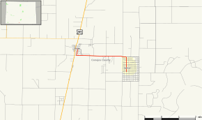
Map of Conejos County in southern Colorado with SH 136 highlighted in red | ||||
| Route information | ||||
| Maintained by CDOT | ||||
| Length: | 4.469 mi[1] (7.192 km) | |||
| Major junctions | ||||
| West end: |
| |||
| East end: | 2nd Street South in Sanford | |||
| Location | ||||
| Counties: | Conejos | |||
| Highway system | ||||
|
Colorado State Highways
| ||||

State Highway 136 (SH 136) is a 4.469-mile-long (7.192 km) state highway in southern Colorado. It runs from an intersection with U.S. Highway 285 (US 285) in La Jara southeast to the community of Sanford.
Route description
SH 136 begins in the west at US 285 in La Jara and proceeds east to Sanford where the route turns abruptly south shortly before reaching its eastern end at an intersection with 2nd Street South in Sanford. The roadway continues southward after the route's terminus, as Main Street.[1]
History
The route was established in the 1920s, when it began at U.S. Highway 285 and ended at SH 159, using a concurrency with SH 142 near San Acacio. The route was paved to its current terminus by 1939, and the rest of the road was deleted in 1954, leaving what it is today.[2]
Major intersections
The entire route is in Conejos County.
| Location | mi[1] | km | Destinations | Notes | |
|---|---|---|---|---|---|
| La Jara | 0.000 | 0.000 | |||
| Sanford | 4.469 | 7.192 | 2nd Street South | Road continues south as Main Street | |
| 1.000 mi = 1.609 km; 1.000 km = 0.621 mi | |||||
References
- 1 2 3 "Online Transportation Information System". Colorado Department of Transportation. Retrieved August 25, 2013.
- ↑ Salek, Matthew E. "Colorado Routes 120-139". Retrieved 2010-05-29.