Colne Estuary
| Site of Special Scientific Interest | |
 | |
| Area of Search | Essex |
|---|---|
| Grid reference | TM075155 |
| Interest |
Biological Geological |
| Area | 2915.2 hectares |
| Notification | 1989 |
| Location map | Magic Map |
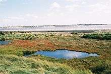
Colne Estuary is a 2915 hectare biological and geological Site of Special Scientific Interest near Brightlingsea in Essex. It is also a Nature Conservation Review site, a National Nature Reserve,[1][2] a Ramsar wetland site of international importance,[3] a Special Protection Area,[4] a Special Area of Conservation,[5] and a Geological Conservation Review site.[6] Three areas in the site are managed by the Essex Wildlife Trust, Colne Point, Fingringhoe Wick and Howlands Marsh.[1]
The site has varied habitats, such as saltmarsh, mud flats, shingle spits and former gravel pits. It is of international importance for wintering brent geese and black-tailed godwits, and of national importance for six other bird species, including little terns. It also has important assemblages of invertebrates and plants, such as golden samphire and shrubby seablite. A peat seam in St Osyph Marsh has been dated to 4280 BP, and this marsh is important for saltmarsh morphology.[1]
There are important geological exposures for Pleistocene studies at East Mersea; investigation is at an early stage, but they show warm climate deposits from one or more post-Anglian interglacials.[1]
| Wikimedia Commons has media related to Colne Estuary. |
References
- 1 2 3 4 "Colne Estuary citation" (PDF). Sites of Special Scientific Interest. Natural England. Archived from the original (PDF) on 8 December 2015. Retrieved 7 December 2015.
- ↑ "Map of Colne Estuary". Sites of Special Scientific Interest. Natural England. Retrieved 7 December 2015.
- ↑ "Colne Estuary (Mid-Essex Coast Phase 2)" (PDF). Joint Nature Conservation Committee. Retrieved 7 December 2015.
- ↑ "Special Protection Area under the EC Birds Directive: Colne Estuary (Mid-Essex Coast Phase 2)" (PDF). Joint Nature Conservation Committee. Retrieved 2 November 2016.
- ↑ "Essex Estuaries". Joint Nature Conservation Committee. Retrieved 6 December 2015.
- ↑ "OTHER DESIGNATED SITES IN THE SEA 3 AREA" (PDF). Department of Trade and Industry. 2002. p. 27. Retrieved 7 December 2015.
Coordinates: 51°48′36″N 0°58′44″E / 51.810°N 0.979°E