Collinwood, Tennessee
| Collinwood, Tennessee | |
|---|---|
| City | |
|
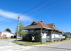
Collinwood Railroad Station | |
 Location of Collinwood, Tennessee | |
| Coordinates: 35°10′13″N 87°44′34″W / 35.17028°N 87.74278°W | |
| Country | United States |
| State | Tennessee |
| County | Wayne |
| Area | |
| • Total | 2.8 sq mi (7.2 km2) |
| • Land | 2.8 sq mi (7.2 km2) |
| • Water | 0.0 sq mi (0.0 km2) |
| Elevation | 1,060 ft (323 m) |
| Population (2010) | |
| • Total | 982 |
| • Density | 365.9/sq mi (141.3/km2) |
| Time zone | Central (CST) (UTC-6) |
| • Summer (DST) | CDT (UTC-5) |
| ZIP code | 38450 |
| Area code(s) | 931 |
| FIPS code | 47-16480[1] |
| GNIS feature ID | 1269482[2] |
| Website |
www |
Collinwood is a city in Wayne County, Tennessee, United States. The population was 982 at the 2010 census, down from 1,024 in 2000.[3]
History
Collinwood was established in 1913 as a stop on the Tennessee Western Railroad, a rail line constructed to serve the area iron industry. The city was named for W.W. Collins, president of the Collinwood Land Company, which platted the city. While the railroad, which intersected the L&N system at Iron City, was originally to extend northward to Hohenwald, plans for extension beyond Collinwood never materialized, and the city became the railroad's western terminus.[4][5]
The Collinwood Land Company advertised lots for the new city in June 1913, and by the following year, about 300 people were living in the city. Most of the residents worked for the railroad or in the local lumber industry. During World War I, Collinwood's economy boomed, and its population swelled to over 2,000. A wood alcohol (methanol) distillation plant and blast furnace were constructed in the years following the war, but as demand for these products fell, the economy collapsed and the city began to decline. The tracks connecting Collinwood with the L&N system were abandoned in the late 1930s.[4]
The Collinwood Railroad Station, built in 1916, still stands near the city of the city, and is listed on the National Register of Historic Places. The station, which mostly follows design patterns typical of L&N depots of the period, is the last major remnant of the area's railroad history.[4] The station now serves as a library and museum.
Geography
Collinwood is located at 35°10′13″N 87°44′34″W / 35.17028°N 87.74278°W (35.170153, -87.742731).[6] The city is situated on a relatively broad plain surrounded by low hills and hollows. Streams in the eastern part of the city are part of the Shoal Creek watershed, while streams in the western part are tributaries of Indian Creek (both Shoal Creek and Indian Creek empty into the Tennessee River).
Collinwood is concentrated along a stretch of State Route 13, roughly halfway between Waynesboro to the north and the Tennessee-Alabama state line to the south. State Route 203 intersects SR 13 at the southern tip of Collinwood, connecting the city with Savannah to the west. The Natchez Trace Parkway traverses Collinwood from northeast to southwest.
According to the United States Census Bureau, the city has a total area of 2.8 square miles (7.3 km2), all of it land.
Demographics
| Historical population | |||
|---|---|---|---|
| Census | Pop. | %± | |
| 1950 | 589 | — | |
| 1960 | 596 | 1.2% | |
| 1970 | 922 | 54.7% | |
| 1980 | 1,064 | 15.4% | |
| 1990 | 1,014 | −4.7% | |
| 2000 | 1,024 | 1.0% | |
| 2010 | 982 | −4.1% | |
| Est. 2015 | 973 | [7] | −0.9% |
| Sources:[8][9] | |||
As of the census[1] of 2000, there were 1,024 people, 428 households, and 297 families residing in the city. The population density was 365.9 people per square mile (141.2/km²). There were 473 housing units at an average density of 169.0 per square mile (65.2/km²). The racial makeup of the city was 98.24% White, 0.20% Native American, 0.10% Asian, 0.88% from other races, and 0.59% from two or more races. Hispanic or Latino of any race were 1.56% of the population.

There were 428 households out of which 30.6% had children under the age of 18 living with them, 52.8% were married couples living together, 13.1% had a female householder with no husband present, and 30.6% were non-families. 27.6% of all households were made up of individuals and 13.3% had someone living alone who was 65 years of age or older. The average household size was 2.39 and the average family size was 2.88.
In the city the population was spread out with 23.7% under the age of 18, 10.9% from 18 to 24, 26.4% from 25 to 44, 25.1% from 45 to 64, and 13.9% who were 65 years of age or older. The median age was 38 years. For every 100 females there were 88.6 males. For every 100 females age 18 and over, there were 86.4 males.
The median income for a household in the city was $22,305, and the median income for a family was $31,296. Males had a median income of $30,052 versus $18,269 for females. The per capita income for the city was $13,716. About 10.4% of families and 16.8% of the population were below the poverty line, including 17.2% of those under age 18 and 21.2% of those age 65 or over.
Businesses/places of interest
- Ralph M. Hughes Memorial Park
- Collinwood City Park—Also known as Dixie Youth Park (Swimming, Tennis, and Baseball)
- Wayne County Welcome Center
- Collinwood Depot Library/Museum
- The Natchez Trace Parkway
- Hasti-Mart
- Roadhouse Express
- Dollar General
- Piggly Wiggly
- Long Green Super Saver
- GG's Market
- The Dragonfly Emporium
Churches
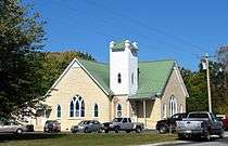
This is an incomplete list of churches located in the city of Collinwood.
- Cornerstone Church of Collinwood
- Collinwood Church of God
- Collinwood Church of Christ
- Collinwood United Methodist Church
- Collinwood Free Will Baptist Church
Education
- Collinwood High
- Collinwood Middle
- Collinwood Elementary
There are also some Columbia State Community College classes at Collinwood High School.
Manufacturing
- Hassell and Hughes[10]
- Dixie Handle Company
Highways and parkways
Radio station
- FM 94.9 WMSR-FM
References
- 1 2 "American FactFinder". United States Census Bureau. Archived from the original on 2013-09-11. Retrieved 2008-01-31.
- ↑ "US Board on Geographic Names". United States Geological Survey. 2007-10-25. Retrieved 2008-01-31.
- ↑ http://2010.census.gov/2010census/popmap/ipmtext.php
- 1 2 3 Richard Quin and Miranda Roche, [ http://focus.nps.gov/GetAsset?assetID=c4bd0632-e2c9-40d3-8879-d4d70d44d418 National Register of Historic Places Inventory Form for Collinwood Railroad Station], September 1987, Sec. 8, pp. 1-4.
- ↑ Bob Rains, "Wayne County," Tennessee Encyclopedia of History and Culture. Accessed 9 November 2016.
- ↑ "US Gazetteer files: 2010, 2000, and 1990". United States Census Bureau. 2011-02-12. Retrieved 2011-04-23.
- ↑ "Annual Estimates of the Resident Population for Incorporated Places: April 1, 2010 to July 1, 2015". Retrieved July 2, 2016.
- ↑ "Census of Population and Housing: Decennial Censuses". United States Census Bureau. Retrieved 2012-03-04.
- ↑ "Incorporated Places and Minor Civil Divisions Datasets: Subcounty Resident Population Estimates: April 1, 2010 to July 1, 2012". Population Estimates. U.S. Census Bureau. Archived from the original on 17 June 2013. Retrieved 11 December 2013.
- ↑ Hassell and Hughes, official website. Accessed 9 November 2016.
External links
 Media related to Collinwood, Tennessee at Wikimedia Commons
- Official website
- Municipal Technical Advisory Service entry for Collinwood – information on local government, elections, and link to charter
Coordinates: 35°10′13″N 87°44′34″W / 35.170153°N 87.742731°W
Municipalities and communities of Wayne County, Tennessee, United States | ||
|---|---|---|
| Cities | ||
| CDP | ||
| Unincorporated communities |
| |
| Footnotes | ‡This populated place also has portions in an adjacent county or counties | |