Coli, Emilia-Romagna
For other uses, see Coli (disambiguation).
| Coli | |
|---|---|
| Comune | |
| Comune di Coli | |
 Coli Location of Coli in Italy | |
| Coordinates: 44°45′N 9°25′E / 44.750°N 9.417°ECoordinates: 44°45′N 9°25′E / 44.750°N 9.417°E | |
| Country | Italy |
| Region | Emilia-Romagna |
| Province / Metropolitan city | Province of Piacenza (PC) |
| Frazioni | Aglio |
| Area | |
| • Total | 72.2 km2 (27.9 sq mi) |
| Population (Dec. 2004) | |
| • Total | 1,030 |
| • Density | 14/km2 (37/sq mi) |
| Time zone | CET (UTC+1) |
| • Summer (DST) | CEST (UTC+2) |
| Postal code | 29020 |
| Dialing code | 0523 |
Coli is a comune (municipality) in the Province of Piacenza in the Italian region Emilia-Romagna, located about 160 kilometres (99 mi) west of Bologna and about 40 kilometres (25 mi) southwest of Piacenza. As of 31 December 2004, it had a population of 1,030 and an area of 72.2 square kilometres (27.9 sq mi).[1]
The municipality of Coli contains the frazione (subdivision) Aglio.
Coli borders the following municipalities: Bettola, Bobbio, Corte Brugnatella, Farini, Ferriere, Travo.
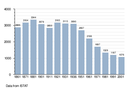
Demographic evolution
References
This article is issued from Wikipedia - version of the 10/8/2016. The text is available under the Creative Commons Attribution/Share Alike but additional terms may apply for the media files.