Coles County, Illinois
| Coles County, Illinois | |
|---|---|
 Coles County Courthouse | |
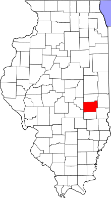 Location in the U.S. state of Illinois | |
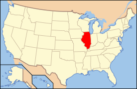 Illinois's location in the U.S. | |
| Founded | December 25, 1830 |
| Named for | Edward Coles |
| Seat | Charleston |
| Largest city | Charleston |
| Area | |
| • Total | 510 sq mi (1,321 km2) |
| • Land | 508 sq mi (1,316 km2) |
| • Water | 1.8 sq mi (5 km2), 0.4% |
| Population | |
| • (2010) | 53,873 |
| • Density | 106/sq mi (41/km²) |
| Congressional district | 15th |
| Time zone | Central: UTC-6/-5 |
| Website |
www |
Coles County is a county located in the U.S. state of Illinois. As of the 2010 census, the population was 53,873.[1] Its county seat is Charleston,[2] which is also the home of Eastern Illinois University.
Coles County is part of the Charleston-Mattoon, IL Micropolitan Statistical Area.
History
Coles County was organized on December 25, 1830 out of Clark and Edgar counties. It was named after Edward Coles,[3] the second governor of Illinois, from 1822 to 1826.
-

Coles County from the time of its creation to 1843
-

Coles County between 1843 and 1859
-

Coles County reduced to its current size in 1859 by the creation of Douglas County
Folklore
Coles County is home to several well-known legends and folktales, including the Mad Gasser of Mattoon and the ghost of Mary Hawkins at Pemberton Hall. Michael Kleen has documented many of these tales, including the "witch's grave" of St. Omer Cemetery and story of "Rag Doll Cemetery," in his book Tales of Coles County, Illinois.[4][5] The legend of "Rag Doll Cemetery" formed the basis of the independent film Rag Doll, which was filmed primarily in and around Mattoon, Illinois in 2010.[6] Additionally, the novel A Family Possessed by L. W. Stevenson is based on poltergeist activity experienced by a rural family living in Coles County in the 1980s.[7] Ashmore Estates has long been a part of local folklore. Originally the almshouse at the Coles County Poor Farm, it is now a haunted attraction and a place of interest for paranormal investigators.[8]
Notable person
- Thomas Lincoln, father of future President Abraham Lincoln, moved to Coles County in 1831 and died there in 1851.
Geography
According to the U.S. Census Bureau, the county has a total area of 510 square miles (1,300 km2), of which 508 square miles (1,320 km2) is land and 1.8 square miles (4.7 km2) (0.4%) is water.[9]
Climate and weather
| Charleston, Illinois | ||||||||||||||||||||||||||||||||||||||||||||||||||||||||||||
|---|---|---|---|---|---|---|---|---|---|---|---|---|---|---|---|---|---|---|---|---|---|---|---|---|---|---|---|---|---|---|---|---|---|---|---|---|---|---|---|---|---|---|---|---|---|---|---|---|---|---|---|---|---|---|---|---|---|---|---|---|
| Climate chart (explanation) | ||||||||||||||||||||||||||||||||||||||||||||||||||||||||||||
| ||||||||||||||||||||||||||||||||||||||||||||||||||||||||||||
| ||||||||||||||||||||||||||||||||||||||||||||||||||||||||||||
In recent years, average temperatures in the county seat of Charleston have ranged from a low of 19 °F (−7 °C) in January to a high of 88 °F (31 °C) in July, although a record low of −27 °F (−33 °C) was recorded in January 1994 and a record high of 110 °F (43 °C) was recorded in July 1936. Average monthly precipitation ranged from 2.20 inches (56 mm) in January to 4.65 inches (118 mm) in July.[10]
Adjacent counties
- Douglas County - north
- Edgar County - northeast
- Clark County - southeast
- Cumberland County - south
- Shelby County - southwest
- Moultrie County - west
Major highways
-
 Interstate 57
 -
 US Route 45
 -
 Illinois Route 16
 -
 Illinois Route 49
 -
 Illinois Route 121
 -
 Illinois Route 130
 -
 Illinois Route 133
Demographics

| Historical population | |||
|---|---|---|---|
| Census | Pop. | %± | |
| 1840 | 9,616 | — | |
| 1850 | 9,335 | −2.9% | |
| 1860 | 14,203 | 52.1% | |
| 1870 | 25,235 | 77.7% | |
| 1880 | 27,042 | 7.2% | |
| 1890 | 30,093 | 11.3% | |
| 1900 | 34,146 | 13.5% | |
| 1910 | 34,517 | 1.1% | |
| 1920 | 35,108 | 1.7% | |
| 1930 | 37,315 | 6.3% | |
| 1940 | 38,470 | 3.1% | |
| 1950 | 40,328 | 4.8% | |
| 1960 | 42,860 | 6.3% | |
| 1970 | 47,815 | 11.6% | |
| 1980 | 52,260 | 9.3% | |
| 1990 | 51,644 | −1.2% | |
| 2000 | 53,196 | 3.0% | |
| 2010 | 53,873 | 1.3% | |
| Est. 2015 | 52,521 | [11] | −2.5% |
| U.S. Decennial Census[12] 1790-1960[13] 1900-1990[14] 1990-2000[15] 2010-2013[1] | |||
As of the 2010 United States Census, there were 53,873 people, 21,463 households, and 11,963 families residing in the county.[16] The population density was 106.0 inhabitants per square mile (40.9/km2). There were 23,425 housing units at an average density of 46.1 per square mile (17.8/km2).[9] The racial makeup of the county was 92.9% white, 3.8% black or African American, 1.0% Asian, 0.2% American Indian, 0.6% from other races, and 1.5% from two or more races. Those of Hispanic or Latino origin made up 2.1% of the population.[16] In terms of ancestry, 25.6% were German, 16.4% were Irish, 11.1% were American, and 10.0% were English.[17]
Of the 21,463 households, 25.5% had children under the age of 18 living with them, 41.8% were married couples living together, 9.9% had a female householder with no husband present, 44.3% were non-families, and 31.4% of all households were made up of individuals. The average household size was 2.30 and the average family size was 2.87. The median age was 31.6 years.[16]
The median income for a household in the county was $36,457 and the median income for a family was $54,170. Males had a median income of $38,915 versus $28,781 for females. The per capita income for the county was $20,601. About 10.6% of families and 20.3% of the population were below the poverty line, including 20.6% of those under age 18 and 5.9% of those age 65 or over.[18]
Communities

Cities
Villages
Townships
Coles County is divided into these twelve townships:
See also
References
- 1 2 "State & County QuickFacts". United States Census Bureau. Retrieved July 4, 2014.
- ↑ "Find a County". National Association of Counties. Archived from the original on 2011-05-31. Retrieved 2011-06-07.
- ↑ Gannett, Henry (1905). The Origin of Certain Place Names in the United States. Govt. Print. Off. p. 87.
- ↑ Tales of Coles County, Illinois. Black Oak Press, Illinois. 2010 [2004].
- ↑ "Student author gets creative with Coles history". Daily Eastern News. 28 October 2005.
- ↑ "Mattoon-based thriller gets a name". Journal Gazette/Times-Courier. 14 May 2010.
- ↑ "A Ghost Story of local proportions". Journal Gazette/Times-Courier. 28 October 2000.
- ↑ "TV team uses technology to root out spirits at Ashmore Estates". Times-Courier. 20 July 2008.
- 1 2 "Population, Housing Units, Area, and Density: 2010 - County". United States Census Bureau. Retrieved 2015-07-11.
- 1 2 "Monthly Averages for Charleston, Illinois". The Weather Channel. Retrieved 2011-01-27.
- ↑ "County Totals Dataset: Population, Population Change and Estimated Components of Population Change: April 1, 2010 to July 1, 2015". Retrieved July 2, 2016.
- ↑ "U.S. Decennial Census". United States Census Bureau. Archived from the original on May 11, 2015. Retrieved July 4, 2014.
- ↑ "Historical Census Browser". University of Virginia Library. Retrieved July 4, 2014.
- ↑ "Population of Counties by Decennial Census: 1900 to 1990". United States Census Bureau. Retrieved July 4, 2014.
- ↑ "Census 2000 PHC-T-4. Ranking Tables for Counties: 1990 and 2000" (PDF). United States Census Bureau. Retrieved July 4, 2014.
- 1 2 3 "DP-1 Profile of General Population and Housing Characteristics: 2010 Demographic Profile Data". United States Census Bureau. Retrieved 2015-07-11.
- ↑ "DP02 SELECTED SOCIAL CHARACTERISTICS IN THE UNITED STATES – 2006-2010 American Community Survey 5-Year Estimates". United States Census Bureau. Retrieved 2015-07-11.
- ↑ "DP03 SELECTED ECONOMIC CHARACTERISTICS – 2006-2010 American Community Survey 5-Year Estimates". United States Census Bureau. Retrieved 2015-07-11.
External links
- County website
- Coles County Online Community
- Illinois State Archives
- U.S. Geological Survey Geographic Names Information System: Coles County, Illinois
 |
Douglas County | Edgar County | | |
| Moultrie County | |
|||
| ||||
| | ||||
| Shelby County | Cumberland County | Clark County |
Municipalities and communities of Coles County, Illinois, United States | ||
|---|---|---|
| Cities | ||
| Villages | ||
| Townships | ||
| Unincorporated communities | ||
| Extinct communities |
| |
| Footnotes | ‡This populated place also has portions in an adjacent county or counties | |
Coordinates: 39°31′13″N 88°13′18″W / 39.52028°N 88.22167°W