Cocos Island
| Cocos Island National Park | |
|---|---|
|
IUCN category II (national park) | |
|
Cocos Island | |
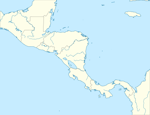 Location in Central America | |
| Location | Approximately 550 km (340 mi) off the shore of Costa Rica |
| Coordinates | 5°31′08″N 87°04′18″W / 5.518889°N 87.071667°WCoordinates: 5°31′08″N 87°04′18″W / 5.518889°N 87.071667°W |
| Established | 1978 |
| Type | Natural |
| Criteria | ix, x |
| Designated | 1997 (21st session) |
| Reference no. | 820 |
| Extension | 2002 |
| State Party | Costa Rica |
| Region | Central America |
| Designated | April 21, 1998 [1] |

Cocos Island (Spanish: Isla del Coco) is an island designated as a National Park off the shore of Costa Rica, that does not allow inhabitants other than Costa Rican Park Rangers. It constitutes the 11th[2] of the 13 districts of Puntarenas Canton of the province of Puntarenas.[3] It is located in the Pacific Ocean, approximately 550 km (342 mi) from the Pacific shore of Costa Rica.[4] With an area of approximately 23.85 km2 (9.21 sq mi), about 8 km × 3 km (5 mi × 2 mi) and a perimeter of around 23.3 km (14.5 mi),[5] this island is more or less rectangular in shape.
Surrounded by deep waters with counter-currents, Cocos Island is admired by scuba divers for its populations of hammerhead sharks, rays, dolphins and other large marine species.[6] The extremely wet climate and oceanic character give Cocos an ecological character that is not shared with either the Galápagos Archipelago or any of the other islands (for example, Malpelo, Gorgona or Coiba) in this region of the world.[7]
Present status and international distinctions
Cocos Island was declared a Costa Rican National Park by means of Executive Decree in 1978. Cocos Island National Park was designated a World Heritage Site by UNESCO in 1997. In 2002, the World Heritage Site designation was extended to include an expanded marine zone of 1,997 km2 (771 sq mi). In addition, it is included in the list of "Wetlands of International Importance".[8]
In 2009 Cocos Island was short-listed as a candidate to be declared one of the New7Wonders of Nature of the world by the New7Wonders of the World Foundation, and ranked second in the islands category.[9]
Thanks to the breathtaking marine life in its waters (see Fauna section below), Cocos Island was named one of the best 10 scuba diving spots in the world by PADI (Professional Association of Diving Instructors) and a "must do" according to diving experts.[10] For many, the main attractions are the large pelagic fish species, which are very abundant in this unique meeting point between deep and shallow waters. The largest schools of hammerhead sharks in the World are consistently reported there. Encounters with dozens if not hundreds of these and other large animals are nearly certain in every dive. Smaller and colorful species are also abundant in one of the most extensive and rich reefs of the south eastern Pacific.[11] The famous oceanographer Jacques Cousteau visited the island several times and in 1994 called it "the most beautiful island in the world". These numerous accolades highlight the urgent need to protect Cocos Island and surrounding waters from illegal large-scale fishing, poaching and other threats.
The only persons allowed to live on Cocos Island are Costa Rican Park Rangers, who have established two encampments, including one at English Bay. Tourists and ship crew members are allowed ashore only with permission of island rangers, and are not permitted to camp, stay overnight or collect any flora, fauna or minerals from the island. Occasional amateur radio DXpeditions are allowed to visit.
This island is popular in pirate lore as well. It is said that over 300 expeditions have gone in search of treasure such as the hoard of Benito Bonito, the Treasure of Lima, and many others. Some incidents of small caches have been discovered, leading many to believe the stories of vast pirate treasures to be valid.
Geology and landscape


Cocos Island is an oceanic island of both volcanic and tectonic origin. It is the only emergent island of the Cocos Plate, one of the minor tectonic plates. Potassium-argon dating established the age of the oldest rocks between 1.91 and 2.44 million years (Late Pliocene)[12] and it is composed primarily of basalt, which is formed by cooling lava.
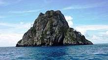
The landscape is mountainous and irregular and the summit is Cerro Iglesias at 575.5 m.[12] In spite of its mountainous character, there are flatter areas between 200–260 m in elevation in the central part of the island, which are said to be a transitional stage of the geomorphological cycle of V-shaped valleys.[13] With four bays, three of them in the north side (Wafer, Chatham and Weston), Cocos Island has a number of short rivers and streams that drain the abundant rainfall into them. Due to large, 300-foot cliffs that ring much of the island, the easiest point of entry is at Chatham Bay.[14] The largest rivers are the Genio and the Pittier, which drain their water into Wafer Bay. The mountainous landscape and the tropical climate combine to create over 200 waterfalls throughout the island. The island's soils are classified as entisols which are highly acidic and could be easily eroded by the island's high rainfall on the steep slopes, were it not for the dense forest coverage.
Climate
The climate of the island is mostly determined by the latitudinal movement of the Intertropical Convergence Zone which creates cloudiness and precipitation that is constant throughout the year.[15] This makes the climate in the island humid and tropical with an average annual temperature of 26.6 °C (79.9 °F) and an average annual rainfall of over 7,000 mm (276 in). Rainfall is high throughout the year, although lower from January through March and slightly lower during late September and October.[16] Numerous oceanic currents from the central Pacific Ocean that converge on the island also have an important influence.
Ecology
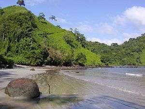
Cocos Island is home to dense and exuberant tropical moist forests. It is the only oceanic island in the eastern Pacific region with such rain forests and their characteristic types of flora and fauna. The cloud forests at higher elevations are also unique in the eastern Pacific. The island was never linked to a continent, so the flora and fauna arrived via long distance dispersal from the Americas. The island has therefore a high proportion of endemic species.
Flora
The island has 235 known species of flowering plants, of which 70, or nearly 30%, are endemic. A good comprehensive study on the flora of the island is provided in the journal Proceedings of the California Academy of Sciences.[17] Also, 74 species of ferns and fern allies (lycopodiophytes and pteridophytes, see[18]), and 128 species of mosses and liverworts (bryophytes, see[19]), 90 species of fungi and 41 species of slimemolds[20] have been reported. Nevertheless, more exhaustive investigations are expected to reveal many more species.
The island has three main plant communities. The coastal forests extend from the seacoast up to 50 meters elevation. Purple coral tree (Erythrina fusca), coconut palm (Cocos nucifera), and pond-apple (Annona glabra) are the predominant trees, with an understory of ferns, shrubs of the Rubiaceae and Solanaceae families, sedges and grasses, and herbaceous plants of the Leguminosae and Malvaceae families.
The inland forests extend from 50 to 500 meters elevation. "Palo de hierro" or huriki (Sacoglottis holdridgei), "avocado" (Ocotea insularis) and the endemic Cecropia pittieri are the most common canopy trees. The trees are festooned at all levels with epiphytic plants, including orchids, ferns, bromeliads and mosses. The understory includes sedges such as Hypolitrum amplum and various species of ferns and tree ferns including Cyathea armata and Danaea media. The endemic palm Rooseveltia frankliniana is also common.
Cloud forests are found at the highest elevations, over 500 meters. Melastoma spp. is predominant.
The general vegetation of Cocos Island has greatly changed since the island was first named and described by Europeans. Captain Wafer, who visited the island in 1685 and whose name was given to the landing place, describes extensive coconut groves extending inland into the interior of the island. Thor Heyerdahl posited that it was very unlikely that these groves developed naturally, and that pre-European man must once have cleared considerable areas in the ravine bottoms and interior plateaus and ridges, utilizing the clearings for coconut plantations of substantial extent. Heyerdahl theorized that these plantations were used to provide fresh liquid and food for pre-Columbian voyages (balsa rafts using guara navigation) between Guatemala and northwestern South America. After the Spanish conquest and its consequences, these voyages ended and the tropical jungle recovered the land that had been laboriously cleared by early human hands.[21]
Fauna
Land fauna
The island has over 400 known species of insects, of which 65 (16%) are endemic. The greatest diversity is found among the Lepidoptera and Formicidae. Over 50 species of other arthropods have been described (spiders, centipedes, millipedes, and isopods).
Two species of lizard are found on the island, an anole (Anolis townsendii) and a gecko (Sphaerodactylus pacificus); both are endemic. No amphibians have been reported.
Nearly 90 bird species have been reported. The island and neighboring rocks are home to large nesting colonies of migratory seabirds, including the brown booby (Sula leucogaster), red-footed booby (Sula sula), great frigatebird (Fregata minor), white tern (Gygis alba) and brown noddy (Anous stolidus). Seven species of land birds inhabit the island, including three endemics: the Cocos cuckoo (Coccyzus ferrugineus), Cocos flycatcher (Nesotriccus ridgwayi) and Cocos finch (Pinaroloxias inornata).[22]
The island has five land mammal species, pigs, deer, goats, cats and rats. All these land mammals were introduced by humans. The Costa Rican government has vowed to control the populations of these animals, as they are harmful to the local ecosystems.[23]
Marine fauna
The rich coral reef, volcanic tunnels, caves, massifs and deeper waters surrounding Cocos Island are home to more than 30 species of coral, 60 species of crustaceans, 600 species of molluscs and over 300 species of fish. These include large populations of yellowfin tuna (Thunnus albacares), giant mantas (Manta birostris), sailfish (Istiophorus platypterus) and sharks, such as whitetip reef shark (Triaenodon obesus) and scalloped hammerhead shark (Sphyrna lewini). The largest of all species of fish is also present, the whale shark (Rhincodon typus).
Other large marine animals include humpback whales (Megaptera novaeangliae), pilot whales (Globicephala macrorhynchus), bottlenose dolphins (Tursiops truncatus), and sea lions(Zalophus californianus).
There are also reptiles; hawksbill turtles (Eretmochelys imbricata), green turtles (Chelonia mydas) and olive ridley turtles (Lepidochelys olivacea).
History
Discovery and early cartography
.jpg)
The 16th century historian Gonzalo Fernández de Oviedo informs in his book Historia General y Natural de las Indias, Islas y Tierra Firme del Mar Océano (Seville, 1535) about the discovery of the island due to the Spanish navigator from Avilés Juan de Cabezas (also known as Juan de Grado) in 1526.[24] D. Lievre, Una isla desierta en el Pacífico; la isla del Coco in Los viajes de Cockburn y Lievre por Costa Rica (1962: 134) tells that the first document with the name "Isle de Coques" is a map painted on parchment, called that of Henry II that appeared in 1542 during the reign of Francis I of France. The planisphere of Nicolás Desliens (1556, Dieppe) places this Ysle de Coques about one and half degrees north of the Equator. (See also Mario A. Boza and Rolando Mendoza, Los parques nacionales de Costa Rica, Madrid, 1981.) Blaeu's Grand Atlas, originally published in 1662, has a colour world map on the back of its front cover which shows I. de Cocos right on the Equator. Frederik De Witt's Atlas, 1680 shows it similarly. The Hondius Broadside map of 1590 shows I. de Cocos at the latitude of 2 degrees and 30 minutes northern latitude, while in 1596 Theodore de Bry shows the Galápagos Islands near 6 degrees north of the Equator. Emanuel Bowen, A Complete system of Geography, Volume II (London, 1747: 586) states that the Galápagos stretch 5 degrees north of the Equator.
Administrative history
The island became part of Costa Rica in 1832 by decree No. 54 of the Constitutional Assembly of the free state of Costa Rica.
Whalers stopped at Cocos Island regularly until the mid-19th century, when inexpensive kerosene started to replace whale oil for lighting.
In October 1863 the ship Adelante dumped 426 Tongan ex-slaves on the island, the captain being too lazy to take them home as promised. When they were saved by the Tumbes, one month later, only 38 had survived, as the rest had perished from smallpox. (See: 'Ata).
In 1897 the Costa Rican government named the German adventurer and treasure hunter August Gissler the first Governor of Cocos Island and allowed him to establish a short-lived colony there.
On May 12, 1970 the insular territory of Cocos Island was incorporated administratively into Central Canton of the Province of Puntarenas by means of Executive Decree No. 27, making it the Eleventh District of Central Canton. The island's 33 residents, the Costa Rican park rangers, were allowed to vote for the first time in Costa Rica's February 5, 2006 election.
Piracy and hidden treasures
The first claims of treasure buried on the island came from a woman named Mary Welsh, who claimed 350 tons of gold (about $16 billion in today's money) raided from Spanish galleons had been buried on the island. She had been a member of a pirate crew led by Captain Bennett Graham, and was transported to an Australian penal colony for her crimes. She possessed a chart showing where Graham's treasure was supposed to be hidden. On her release she returned to the island with an expedition, which had no success in finding anything, with the points of reference in the chart having disappeared.[25]
Another pirate supposed to have buried treasure on the island was the Portuguese Benito Bonito.[26][27] Though Bonito was hunted down and executed, his treasure was never retrieved.[27]
The best known of the treasure legends tied to the island is that of the Treasure of Lima. In 1820, with the army of José de San Martín approaching Lima, Viceroy José de la Serna is supposed to have entrusted treasure from the city to British trader Captain William Thompson for safekeeping until the Spaniards could secure the country. Instead of waiting in the harbor as they were instructed,[28] Thompson and his crew killed the Viceroy's men and sailed to Cocos, where they buried the treasure.[26][27] Shortly afterwards, they were apprehended by a Spanish warship. All of the crew except Thompson and his first mate were executed for piracy. The two said they would show the Spaniards where they had hidden the treasure in return for their lives – but after landing on Cocos, they escaped into the forest.[27]
Hundreds of attempts to find treasure on the island have failed.[27][29] Several early expeditions were mounted on the basis of claims by a man named Keating, who was supposed to have befriended Thompson. On one trip, Keating was said to have retrieved gold and jewels from the treasure.[30][31] Prussian adventurer August Gissler lived on the island for most of the period from 1889 until 1908, hunting the treasure with the small success of finding six gold coins.[27]
Treasure of Lima: A Buried Exhibition
Treasure of Lima: A Buried Exhibition is an art project curated by Nadim Samman for Thyssen-Bornemisza Art Contemporary Academy and commissioned by Francesca von Habsburg. Works by forty internationally celebrated artists were placed inside an exhibition architecture (that is, contemporary ‘treasure’ chest) designed by architects Aranda\Lasch and then buried at a secret location on Cocos Island in May 2014. The GPS coordinates (or ‘map’) of the exhibition location were logged at the site of burial. These coordinates were then given to the Dutch artist Constant Dullaart, who worked with a leading cryptographer to encode them. The resulting string of code was then made physical as a 3D printed steel cylinder and placed inside a second version of the chest. This chest will be auctioned to raise funds for a shark research and conservation initiative on Cocos Island. The buyer will not receive the de-encryption key.
Treasure of Lima: A Buried Exhibition brought artists, marine biologists, collectors, and sailors together to engage with conservation issues while exploring the history of piracy on Cocos, the politics of access and exclusion in the fields of art and natural heritage, as well as the limits of the exhibition format.
Habitats threatened
The mostly unperturbed habitats are, however, under growing human pressure. Illegal poaching of large marine species in and around its protected waters has become a main concern.[32] Growing local and worldwide demand for tuna, shark fin soup and other seafood is threatening the island's fragile ecosystems.[33] The government of Costa Rica has been openly accused of passivity and even benefiting corruptly from illegal shark fin and other seafood trade to large markets, such as China and other Asian countries.[34] The government has shown some willingness to protect the island's natural riches and prosecute poachers.[35] However, efforts to effectively patrol the waters and enforce environmental laws face big financial and bureaucratic difficulties, as well as being prone to the corruption of local, national and international authorities.
Recent events show that large-scale illegal poaching keeps happening. Despite initial hope in stopping and charging poachers,[36] who have been caught with abundant evidence,[37] they have been quickly released under suspicious circumstances.[38] Also, efforts to raise funds for protection have been dwarfed.
Marvin Orlando Cerdas, a judge with the local Puntarenas Court of Justice, obscurely allowed 22 poachers caught red-handed to escape the country.[38]
Also under highly suspicious and allegedly corrupt circumstances, the District Attorney Michael Morales Molina, stopped the auction for public benefit of confiscated goods, immediately after the spokesman of the large illegal poacher ship "Tiuna" simply made the request.[39]
Cocos Island in fiction
The book Desert Island[40] proposed the highly detailed theory that Daniel Defoe used the Isla del Coco as an accurate model for his descriptions of the island inhabited by the marooned Robinson Crusoe. However Defoe placed Crusoe's island not in the Pacific, but rather off the coast of Venezuela in the Atlantic Ocean.[41]
Robinson's neighbouring Terra Firma is shown on the colour map of Joannes Jansson (Amsterdam) depicting the northeastern corner of South America, entitled Terra Firma et Novum Regnum Granatense et Popayan. It belongs to the early group of plates printed by William Blaeu from 1630 onwards. The properly called Terra Firma was the Isthmus of Darien.[42] Crusoe's two references to Mexico are against a South American island as well.
The Clive Cussler novel The Silent Sea (2010) references mystic Chinese pirate tales but locates the island off the northern Pacific coast of the US.
References
- ↑ "Ramsar List". Ramsar.org. Archived from the original on 9 April 2013. Retrieved 13 April 2013.
- ↑ Isla Coco
- ↑ GUIA DE CODIGOS TRIBUTARIOS
- ↑ Hogue, C. and Miller, S. 1981. Entomofauna of Cocos Island, Costa Rica. Atoll Research Bulletin 250: 1–29.
- ↑ Montoya, M. 2007. Conozca la Isla del Coco: una guía para su visitación. In Biocursos para amantes de la naturaleza: Conozca el parque nacional Isla del Coco, la isla del tesoro (26 abril al 6 de mayo 2007). (ed. Organization for Tropical Studies). Organization for Tropical Studies. San José, Costa Rica. 35–176.
- ↑ Shark-counting divers off Costa Rica reveal limits of marine reserves
- ↑ Kirkendall, L. and Jordal, B. 2006. The bark and ambrosia beetles (Curculionidae, Scolytinae) of Cocos Island, Costa Rica and the role of mating systems in island zoogeography. Biological Journal of the Linnean Society 89(4): 729–743.
- ↑ Ramsar Convention text in English
- ↑ New 7 Wonders of the Word: Live Ranking
- ↑ World's 10 best scuba spots - Active - MSNBC.com
- ↑ Guzmán, H. M. and Cortés, J. (1992). Cocos Island (Pacific of Costa Rica) coral reefs after the 2010-83 El Niño disturbance. Revista de Biología Tropical 40: 309–324.
- 1 2 Castillo, P., Batiza, R., Vanko, D., Malavassi, E., Barquero, J., and Fernandez, E. 1988. Anomalously young volcanoes on old hot-spot traces. I. Geology and petrology of Cocos Island. Geological Society of America Bulletin 100: 1400–1414.
- ↑ Malavassi, E. 1982. Visita al Parque Nacional Isla del Coco. Revista Geográfica de América Central (15–16): 211–216.
- ↑ Stater, Adam. "Chatham Bay, Cocos Island".
- ↑ Herrera, W. 1984. Informe de campo. Gira realizada a la Isla del Coco con el objetivo de recabar información climatológica. San José, Servicio de Parques Nacionales, 6 p.
- ↑ Sinergia 69. 2000. Volumen 2. Aspectos meteorológicos y climatológico del ACMIC y su área de influencia. San José, Proyecto GEF/PNUD Conocimiento y uso de la biodiversidad del ACMIC, 184 p.
- ↑ Trusty, J.L., Kesler, H.C. and Haug-Delgado, G. 2006. Vascular flora of Isla del Coco, Costa Rica. Proceedings of the California Academy of Sciences (Fourth Series) 57(7): 247–355.
- ↑ Gomez, L.D. 1975. The Ferns and Fern-Allies of Cocos Island, Costa Rica. American Fern Journal 65 (4): 102–104.
- ↑ Dauphin G. 1999. Bryophytes of Cocos Island, Costa Rica: diversity, biogeography and ecology. Revista de Biología Tropical. 47:309–328
- ↑ Rojas, C. and Stephenson, S.L. 2008. Myxomycete ecology along an elevation gradient on Cocos Island, Costa Rica. Fungal Diversity 29: 119–129.
- ↑ Heyerdahl, T. 1978. Early Man and the Ocean. Doubleday & Company, New York
- ↑ Stater, Adam. "Endemic Birds of Cocos Island".
- ↑ nacion.com: ALDEA GLOBAL "País en guerra contra especies invasoras de isla del Coco"
- ↑ J. Lines, Diario de Costa Rica, May 12, 1940
- ↑ "Legends and Lore". PBS.org. Retrieved May 27, 2011.
- 1 2 MacInnis, Joe (1975). Underwater Man. New York: Dodd, Mead & Company. p. 28. ISBN 0-396-07142-2. OCLC 1166443.
- 1 2 3 4 5 6 "Legends and Lore (Part 2)". PBS.org. Retrieved May 27, 2011.
- ↑ "American Castaways Are Found On Tropical Island". The Daily News (Huntingdon, Pennsylvania). 29 October 1931.
The ship had a slip-hawser on its anchor and instructions to await developments. But the captain and crew had ideas of their own. When morning came, Lima was still in the hands of the patriots but their treasures had vanished.
- ↑ "Briton given permission to look for legendary treasure of Lima". The Daily Telegraph. 26 July 2010.
- ↑ Walter Noble Burns (11 November 1911). "The Treasure of Cocos Island; The Romantic History of a Pirate Hoard on an Island in the Pacific". Newburg Telegram.
- ↑ MacInnis, pp. 29–30.
- ↑ Eco-Exchange - April-May 2001 - Modern-Day Pirates Plunder Saltwater Booty Near Costa Rica's Fabled Cocos Island
- ↑ 38 Million Sharks Killed for Fins Annually, Experts Estimate
- ↑ "CNN.com - Transcripts". CNN.
- ↑ Costa Rica Court Rules for Sea Turtles, Jails Captain
- ↑ Cae atunero con pesca ilegal en Isla del Coco - EL PAÍS - nacion.com
- ↑ El ‘Tiuna’ traía más de 280 toneladas de atún y explosivos - EL PAÍS - nacion.com
- 1 2 Juez puntarenense levanta medidas cautelares a atuneros - EL PAÍS - nacion.com
- ↑ Dall’Anese: ‘La isla del Coco está perdida’ - EL PAÍS - nacion.com
- ↑ Robinson Crusoe Enterprises, North Vancouver, 1996
- ↑ See discussion page for further details.
- ↑ Bowen, 1747: 593, and Charles Theodore Middleton, A new and Complete System of Geography, Volume II, London, printed for J. Cooke, 1777–1778, page 448
External links
- Cocos Island National Park institutional website
- "Cocos Island moist forests". Terrestrial Ecoregions. World Wildlife Fund.
- Island of the Sharks - Legends and Lore
- Pirates of the Collection: and the quest for the 'Treasure of Lima'
- De Montmorency, Hervey Guy Francis Edward, 1868-1942. "On the track of a treasure : the story of an adventurous expedition to the Pacific island of Cocos in search of treasure of untold value hidden by pirates", London : Hurst and Blackett, 1904.
Eastern Pacific Islands | |||||||||||
|---|---|---|---|---|---|---|---|---|---|---|---|
| |||||||||||
| |||||||||||
| |||||||||||
| |||||||||||
| |||||||||||
| |||||||||||