Cockburn Town
| Cockburn Town | |
|---|---|
| Capital city | |
 | |
 Turks and Caicos Islands position in the North Atlantic Ocean | |
 Map showing Cockburn Town's position with Turks and Caicos | |
| Coordinates: 21°27′32″N 71°08′20″W / 21.459°N 71.139°WCoordinates: 21°27′32″N 71°08′20″W / 21.459°N 71.139°W | |
| Country |
|
| Overseas territory |
|
| District | Grand Turk |
| Founded | 1681 |
| Population | |
| • Town | 3,700 |
| Climate | BSh |
Cockburn Town (/ˈkoʊbərn/ KOH-bərn)[1][2] is the capital city of the Turks and Caicos Islands.
Geography
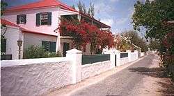
Cockburn Town is located on the largest island in the Turks Islands archipelago, Grand Turk Island. Historic 18th and 19th century Bermudian architecture line Duke and Front Streets in the town. The town is known for its long, narrow streets and old street lamps.
The closest anchorage to Cockburn Town is Hawk's Nest Anchorage, which, though sheltered, should only be entered in good light because of reefs near the entrance.
History
The seat of government ever since 1766, Cockburn Town was the first permanent settlement on any of the islands, founded in 1681 by salt collectors who arrived in the Turks and Caicos Islands. The city supposedly lies on the place where Juan Ponce de León first landed on the island.
Main sights
National Museum

Cockburn Town is home to the Turks & Caicos National Museum, which is housed in the colonial-era Guinep House, on Front Street. The house is believed to be over 180 years old and much of its structural material came from local shipwrecks, including a ship's mast, which is one of the building's main supports. The site was donated to the Museum in 1990.[3]
Among the National Museum's collections is an exhibit of shipwrecks, including the oldest known European shipwreck in the Americas, the Molasses Reef Wreck, dated 1505.[4]
Other exhibits detail the history of the Lucayans, the Space Race, Turks and Caicos postage stamps, slavery and the history of the slave trade, the sisal and salt industries, royal events, as well as a general history of the islands. The museum also maintains a garden, which is adjacent to the Guinep House.[5]
Also of interest are the museum's research projects, including its Message in a Bottle Project, recording nearly 40 years' worth of messages to wash upon the shores of Grand Turk.[6]
Climate
| Climate data for Grand Turk | |||||||||||||
|---|---|---|---|---|---|---|---|---|---|---|---|---|---|
| Month | Jan | Feb | Mar | Apr | May | Jun | Jul | Aug | Sep | Oct | Nov | Dec | Year |
| Average high °C (°F) | 27 (80) |
27 (81) |
28 (82) |
28 (83) |
29 (85) |
30 (86) |
31 (87) |
31 (88) |
31 (88) |
30 (86) |
29 (84) |
28 (82) |
29 (84) |
| Average low °C (°F) | 23 (73) |
23 (73) |
23 (74) |
24 (75) |
25 (77) |
26 (79) |
27 (80) |
27 (80) |
27 (80) |
26 (79) |
24 (76) |
24 (75) |
25 (77) |
| Average precipitation mm (inches) | 36 (1.4) |
33 (1.3) |
30 (1) |
36 (1.4) |
30 (1.2) |
56 (2.2) |
30 (1.2) |
41 (1.6) |
66 (2.6) |
80 (3) |
94 (3.7) |
86 (3.4) |
605 (23.8) |
| Source: Weatherbase [7] | |||||||||||||
References
- ↑ Turks & Caicos travel information, caribbean.com, retrieved 2008-11-02
- ↑ Grand Turk Island, Turks & Caicos, Professional Travel Guide, retrieved 2008-11-02
- ↑ "Guinep House". Turks & Caicos National Museum. Retrieved January 29, 2010.
- ↑ "Molasses Reef Shipwreck". Turks & Caicos National Museum. Retrieved January 29, 2010.
- ↑ Turks & Caicos National Museum. Retrieved January 29, 2010.
- ↑ "Message in a Bottle". Turks & Caicos National Museum. Retrieved January 29, 2010.
- ↑ "Weatherbase: Historical Weather for Grand Turk, Turks and Caicos Islands". Weatherbase. 2011. Retrieved on November 24, 2011.
External links
 Media related to Cockburn Town at Wikimedia Commons