Cnoc Coinnich
| Cnoc Coinnich | |
|---|---|
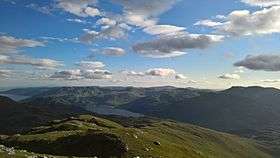 View from near the summit of Cnoc Coinnich | |
| Highest point | |
| Elevation | 763.5 m (2,505 ft) |
| Listing | Corbett, Marilyn |
| Coordinates | 56°09′59″N 4°50′47″W / 56.1665°N 4.8463°WCoordinates: 56°09′59″N 4°50′47″W / 56.1665°N 4.8463°W |
| Geography | |
| Location | Argyll and Bute, Scotland |
| Parent range | Arrochar Alps |
Cnoc Coinnich is a Corbett situated on the Ardgoil Peninsula in the Argyll & Bute council region and forms part of the Arrochar Alps. A Corbett is a Scottish mountain at least 2500ft but under 3000ft (between 762 and 914.4 metres) in height with a drop of at least 500ft on all sides.[1]
Cnoc Coinnich missed out on Corbett status by one metre until July 2016 when it was resurveyed at the instigation of the Scottish Mountaineering Club (SMC). The new height is 763.5m, changing its classification from one of the highest Grahams (second only in alphabetic order to Beinn Talaidh) to Corbett.[2] The height was ratified by the Ordnance Survey and will be shown as 764m on its maps.[3]
The hill is easily ascended from either Lochgoilhead, or from Artgartan on the A83 and is not far off the course of the Cowal Way long distance footpath. It is often climbed together with The Brack another Corbett which lies at the other side of the Coilessan bealach (col).
Cnoc Coinnich is topped by a small cairn at grid reference NN233007.
References
- ↑ "MCofS - Munros & Corbetts - The Corbetts". www.mcofs.org.uk. Retrieved 2016-07-03.
- ↑ "Hill sleuths' journey into mist reveals Cnoc Coinnich measures up to Corbett status". Retrieved 2016-06-30.
- ↑ "A New Corbett for Scotland". Retrieved 2016-07-09.