Clyde, California
| Clyde | |
|---|---|
| Census-designated place | |
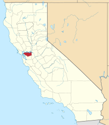
 Location in Contra Costa County and the state of California | |
 Clyde Location in the United States | |
| Coordinates: 38°01′32″N 122°01′46″W / 38.02556°N 122.02944°WCoordinates: 38°01′32″N 122°01′46″W / 38.02556°N 122.02944°W | |
| Country |
|
| State |
|
| County | Contra Costa |
| Government | |
| • State Senate | Steve Glazer (D)[1] |
| • State Assembly | Tim Grayson (D)[2] |
| • U. S. Congress | Mark DeSaulnier (D)[3] |
| Area[4] | |
| • Total | 0.134 sq mi (0.347 km2) |
| • Land | 0.134 sq mi (0.347 km2) |
| • Water | 0 sq mi (0 km2) 0% |
| Elevation[5] | 23 ft (7 m) |
| Population (2010) | |
| • Total | 678 |
| • Density | 5,100/sq mi (2,000/km2) |
| Time zone | PST (UTC-8) |
| • Summer (DST) | PDT (UTC-7) |
| ZIP code | 94520 |
| Area code(s) | 925 |
| FIPS code | 06-14232 |
| GNIS feature IDs | 1658292, 2407641 |
Clyde is a census-designated place (CDP) in Contra Costa County, California, United States. The population was 678 at the 2010 census. It is located 6 miles (10 km) east of Martinez.[6]
Geography
According to the United States Census Bureau, the CDP has a total area of 0.1 square miles (0.26 km2), all of it land.
Demographics
2010
The 2010 United States Census[7] reported that Clyde had a population of 678. The population density was 5,054.5 people per square mile (1,951.6/km²). The racial makeup of Clyde was 530 (78.2%) White, 11 (1.6%) African American, 4 (0.6%) Native American, 58 (8.6%) Asian, 3 (0.4%) Pacific Islander, 25 (3.7%) from other races, and 47 (6.9%) from two or more races. Hispanic or Latino of any race were 99 persons (14.6%).
The Census reported that 100% of the population lived in households.
There were 248 households, out of which 82 (33.1%) had children under the age of 18 living in them, 125 (50.4%) were opposite-sex married couples living together, 29 (11.7%) had a female householder with no husband present, 13 (5.2%) had a male householder with no wife present. There were 13 (5.2%) unmarried opposite-sex partnerships, and 1 (0.4%) same-sex married couples or partnerships. 57 households (23.0%) were made up of individuals and 10 (4.0%) had someone living alone who was 65 years of age or older. The average household size was 2.73. There were 167 families (67.3% of all households); the average family size was 3.26.
The population was spread out with 151 people (22.3%) under the age of 18, 65 people (9.6%) aged 18 to 24, 175 people (25.8%) aged 25 to 44, 234 people (34.5%) aged 45 to 64, and 53 people (7.8%) who were 65 years of age or older. The median age was 38.4 years. For every 100 females there were 98.8 males. For every 100 females age 18 and over, there were 98.9 males.
There were 264 housing units at an average density of 1,968.1 per square mile (759.9/km²), of which 193 (77.8%) were owner-occupied, and 55 (22.2%) were occupied by renters. The homeowner vacancy rate was 2.5%; the rental vacancy rate was 5.2%. 528 people (77.9% of the population) lived in owner-occupied housing units and 150 people (22.1%) lived in rental housing units.
2000
As of the census[8] of 2000, there were 694 people, 267 households, and 174 families residing in the CDP. The population density was 4,944.0 people per square mile (1,914.0/km²). There were 267 housing units at an average density of 1,902.1 per square mile (736.4/km²). The racial makeup of the CDP was 81.56% White, 1.15% Black or African American, 0.29% Native American, 6.92% Asian, 0.29% Pacific Islander, 4.32% from other races, and 5.48% from two or more races. 11.38% of the population were Hispanic or Latino of any race.
There were 267 households out of which 36.7% had children under the age of 18 living with them, 52.1% were married couples living together, 10.1% had a female householder with no husband present, and 34.5% were non-families. 25.1% of all households were made up of individuals and 5.2% had someone living alone who was 65 years of age or older. The average household size was 2.60 and the average family size was 3.14.
In the CDP the population was spread out with 26.8% under the age of 18, 5.6% from 18 to 24, 37.6% from 25 to 44, 24.1% from 45 to 64, and 5.9% who were 65 years of age or older. The median age was 37 years. For every 100 females there were 98.9 males. For every 100 females age 18 and over, there were 93.9 males.
The median income for a household in the CDP was $66,875, and the median income for a family was $80,137. Males had a median income of $51,786 versus $41,250 for females. The per capita income for the CDP was $30,822. None of the families and 1.9% of the population were living below the poverty line, including no under eighteens and 18.8% of those over 64.
History
In 1917, the United States Shipping Board provided a government loan to the Pacific Coast Shipbuilding Company to build a company town.[9] The Board commissioned Bernard Maybeck to be Supervising Architect for laying out the new town. He designed the hotel and around 200 of the initial homes built in the town. George Applegarth was hired as Acting Architect. In this position, he drew many of the plans for the town.[10]
References
- ↑ "Senators". State of California. Retrieved March 28, 2013.
- ↑ "Members Assembly". State of California. Retrieved March 28, 2013.
- ↑ "California's 11th Congressional District - Representatives & District Map". Civic Impulse, LLC. Retrieved March 9, 2013.
- ↑ "2010 Census U.S. Gazetteer Files – Places – California". United States Census Bureau.
- ↑ "Clyde". Geographic Names Information System. United States Geological Survey.
- ↑ Durham, David L. (1998). California's Geographic Names: A Gazetteer of Historic and Modern Names of the State. Clovis, Calif.: Word Dancer Press. p. 617. ISBN 1-884995-14-4.
- ↑ "2010 Census Interactive Population Search: CA - Clyde CDP". U.S. Census Bureau. Retrieved July 12, 2014.
- ↑ "American FactFinder". United States Census Bureau. Archived from the original on September 11, 2013. Retrieved 2008-01-31.
- ↑ "George A. Applegarth". Environmental Design Archives. University of California, Berkeley. July 15, 2003. Retrieved 2007-07-02.
- ↑ McCoy, Esther (1960). Five California Architects. New York: Reinhold Publishing Corporation. pp. 47–8. ASIN B000I3Z52W.
| Bodies of water |
|  |
|---|---|---|
| Counties | ||
| Major cities | ||
| Cities and towns 100k–250k | ||
| Cities and towns 50k–99k | ||
| Cities and towns 25k-50k | ||
| Cities and towns 10k–25k |
| |
| Sub-regions | ||