Clinton River (Michigan)
| Clinton River | |
|---|---|
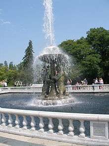
 The Clinton River in Macomb County | |
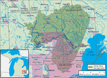 A map of the Clinton River and its watershed | |
| Country | United States |
| State | Michigan |
| Counties | Oakland, Macomb |
| Basin | |
| River mouth |
Lake St. Clair 42°35′24.76″N 82°49′17.17″W / 42.5902111°N 82.8214361°WCoordinates: 42°35′24.76″N 82°49′17.17″W / 42.5902111°N 82.8214361°W |
| Basin size | 760 square miles (2,000 km2) |
| Physical characteristics | |
| Length | 83 miles (134 km) |
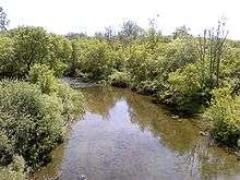
The Clinton River is a river in southeastern Michigan in the United States.
The main branch of the river rises from wetlands in Springfield Township, Oakland County, northwest of Pontiac. A series of dams create a number of small lakes west of Pontiac, the last of which is Crystal Lake. The river is piped under downtown Pontiac, re-emerging to the east of downtown.[1] The north branch and the middle branch rise in northern Macomb County and join the main branch in Charter Township of Clinton, which was named after the river. The main branch flows 83.0 miles (133.6 km)[2] from its headwaters to Lake St. Clair in Harrison Township, Michigan.
The Clinton River watershed drains 760 square miles (2,000 km2), including most of Macomb County, a large portion of Oakland County and small portions of Lapeer County and St. Clair County. More than 1.4 million people in over 60 municipalities live in the watershed. For the most part, only the waters located downstream of the city of Mount Clemens are navigable by industrial water vessels.
Under the Great Lakes Water Quality Agreement in 1972, along with 42 other areas, the lower segment of the river was designated as an Area of Concern, based on the heavy presence of pollutant contamination. In 1995, the designation was expanded to include the entire watershed of the river and the lower nearshore of Lake St. Clair.
The Clinton-Kalamazoo Canal was a failed attempt to build a waterway connecting Lake St. Clair with Lake Michigan. It was originally planned to stretch 216 miles, but was abandoned after only 13 miles had been completed.[3]

The river was renamed in honor of DeWitt Clinton, the governor of New York from 1817 to 1823. Previously, the river had been known as the "Nottawasippee" by the French and Native Americans. The word Nottawasippee is an Anishnabek term that means "like rattlesnakes," which was a name given to the Huron people by the Ojibwa, Odawa and Bwaadaawatomee.[4]
The English referred to it as the Huron River of St. Clair. It was referred to as "The River Huron" in the 1784 home eulogy of the area's first white settler, William Tucker, who built his home along the river about 3 miles (5 km) upstream. The name was changed on July 17, 1824, by the Michigan Territorial Council to avoid confusion caused by the many other places known as "Huron" in eastern Michigan, including the Huron River which rises in adjacent Oakland County. The same legislative act also changed the name of Huron Township in Macomb County to Clinton Township.[5]
The Huron-Clinton Metroparks system preserves land in the watershed as public parks; Wolcott Mill Metropark is on the north branch of the river.
Riverland Amusement Park was located in the watershed in Macomb County in the 1980s.
References
- ↑ A River Through Time (The Mainstream of the Clinton River)
- ↑ U.S. Geological Survey. National Hydrography Dataset high-resolution flowline data. The National Map Archived 2012-04-05 at WebCite, accessed November 7, 2011
- ↑ http://www.rochesterhills.org/city_services/museum/history/clinton-kalamazoo_canal.asp
- ↑ Genot Picor-Storyteller
- ↑ Leeson, Michael A. (2005) [1882]. "Organization". History of Macomb County. Ann Arbor, Mich.: University of Michigan Library. p. 297. Retrieved 2006-10-01.
External links
| Wikimedia Commons has media related to Clinton River (Michigan). |
| Topics | 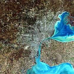 | |
|---|---|---|
| Detroit | ||
| Municipalities over 80,000 | ||
| Municipalities 40,000 to 80,000 | ||
| Cultural enclaves | ||
| Satellite cities | ||
| Counties in MSA | ||
| Counties in CSA | ||