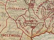
Shire of Clifton
| Shire of Clifton Queensland | |||||||||||||
|---|---|---|---|---|---|---|---|---|---|---|---|---|---|
 Location within Queensland | |||||||||||||
| Population | 2,549 (2006 census)[1] | ||||||||||||
| • Density | 2.9383/km2 (7.6102/sq mi) | ||||||||||||
| Established | 1879 | ||||||||||||
| Area | 867.5 km2 (334.9 sq mi) | ||||||||||||
| Council seat | Clifton | ||||||||||||
| Region | Darling Downs | ||||||||||||
 | |||||||||||||
| Website | Shire of Clifton | ||||||||||||
| |||||||||||||
The Shire of Clifton was a local government area in the Darling Downs region of Queensland, Australia, southwest of the regional city of Toowoomba. The shire, administered from the town of Clifton, covered an area of 867.5 square kilometres (334.9 sq mi), and existed as a local government entity from 1879 until 2008, when it amalgamated with several other councils in the Toowoomba area to form the Toowoomba Region.
History

The Clifton Division was incorporated on 11 November 1879 under the Divisional Boards Act 1879 with a population of 1382.[2][3]
With the passage of the Local Authorities Act 1902, the Clifton Division became the Shire of Clifton on 31 March 1903.[3]
On 23 January 1915, part of the Shire of Clifton was amalgamated with the Town of Allora to create the new Shire of Allora. The Shire of Clifton continued with smaller boundaries.[4][5][6]
On 15 March 2008, under the Local Government (Reform Implementation) Act 2007 passed by the Parliament of Queensland on 10 August 2007, the Shire of Clifton merged with the City of Toowoomba and the Shires of Cambooya, Crows Nest, Jondaryan, Millmerran, Pittsworth and Shire of Rosalie to form the Toowoomba Region.[3][7]
Towns and localities
The Shire of Clifton includes the following settlements:
1 - split with the former Shire of Cambooya
Population
| Year | Population |
|---|---|
| 1933 | 3,105 |
| 1947 | 2,760 |
| 1954 | 2,542 |
| 1961 | 2,572 |
| 1966 | 2,549 |
| 1971 | 2,378 |
| 1976 | 2,260 |
| 1981 | 2,188 |
| 1986 | 2,354 |
| 1991 | 2,301 |
| 1996 | 2,308 |
| 2001 | 2,327 |
| 2006 | 2,549 |
Chairmen and mayors
The leaders of the Clifton Division and Clifton Shire were:[8]
Clifton Divisional Board
- Charles Clarke (1880—1881)
- James Hanly (1881—1882)
- Thomas Grimes (1882—1883)
- William Deacon (1883—1885)
- George Clarke (1886—1888)
- William Deacon (1889—1890)
- James Hanly (1890—1891)
- John Logan (1891—1892)
- John Keleher (1892—1893)
- Andrew Gordon (1893—1894)
- James Hanly (1894—1895)
- Edward Harvey (1895—1896)
- John Logan (1896—1897)
- Edward Harvey (1897—1898)
- Maas Henry Hinz (1899—1900)
- James Bourke (1900—1901)
- Jeremiah Collins (1901—1902)
- John Keleher (1902—1903)
Clifton Shire Council
- Charles Young Gillam (1903—1904)
- Bernard McGovern (1904—1905)
- John Logan (1905—1906)
- Charles Young Gillam (1906—1907)
- John O'Sullivan (1907—1908)
- Edward Cooper (1908—1909)
- Phillip Henry Imhoff (1909—1910)
- John Logan (1910—1911)
- James Purcell (1911—1913)
- Henry Allen Smith (1913—1914)
- James Bourke (1914—1915)
- John Logan (1915—1916)
- John Gallagher (1916—1917)
- James Meara (1917—1921)
- Walter Robert Ross (1922—1923)
- James Meara (1924—1947)
- Heinrich Heinrichsen (1947—1949)
- Herbert Warfield (1949—1955)
- William Bourke (1955—1967)
- William Finlay (1967—1976)
- Virgil O'Leary (1976—1979)
- William Bishop (1979—1982)
- Emmett Lyons (1982—1991)
- Ian Jones (1991—1994)
- Reg Murphy (1994—1997)
- Patricia Collins (1997—2004)
- Ian Jones (2004—2008)
References
- ↑ Australian Bureau of Statistics (25 October 2007). "Clifton (S) (Local Government Area)". 2006 Census QuickStats. Retrieved 2008-03-18.
- ↑ "Proclamation [Clifton Division]". Queensland Government Gazette. 11 November 1879. p. 25:995.
- 1 2 3 "Agency ID577, Clifton Shire Council". Queensland State Archives. Retrieved 10 September 2013.
- ↑ "Agency ID293, Allora Town Council". Queensland State Archives. Retrieved 10 September 2013.
- ↑ "Agency ID292, Allora Shire Council". Queensland State Archives. Retrieved 10 September 2013.
- ↑ "NEW SHIRE OF ALLORA,.". Warwick Examiner and Times (Qld. : 1867 - 1919). Qld.: National Library of Australia. 23 January 1915. p. 3. Retrieved 10 September 2013.
- ↑ "Agency ID11041, Toowoomba Regional Council". Queensland State Archives. Retrieved 10 September 2013.
- ↑ "Clifton Shire Council - Past Chairmen and Mayors". Toowoomba Regional Council. 7 December 2012. Retrieved 17 January 2014.
External links
- "Clifton Shire". Queensland Places. Centre for the Government of Queensland, University of Queensland.
Coordinates: 27°55′53.6″S 151°54′30.7″E / 27.931556°S 151.908528°E