Clifton, Arizona
| Clifton, Arizona | |
|---|---|
| Town | |
|
Old train depot, built 1913, now used by the Chamber of Commerce | |
| Motto: "Where the trail begins" | |
 Location in Greenlee County and the state of Arizona | |
 Clifton, Arizona Location in the United States | |
| Coordinates: 33°2′26″N 109°18′3″W / 33.04056°N 109.30083°WCoordinates: 33°2′26″N 109°18′3″W / 33.04056°N 109.30083°W | |
| Country | United States |
| State | Arizona |
| County | Greenlee |
| Area | |
| • Total | 14.8 sq mi (38.4 km2) |
| • Land | 14.6 sq mi (37.8 km2) |
| • Water | 0.2 sq mi (0.6 km2) |
| Elevation | 3,478 ft (1,060 m) |
| Population (2010)[1] | |
| • Total | 3,311 |
| • Estimate (2015)[2] | 3,685 |
| • Density | 252/sq mi (97.4/km2) |
| Time zone | MST (no DST) (UTC-7) |
| ZIP code | 85533 |
| Area code(s) | 928 |
| FIPS code | 04-14380 |
| Website |
cliftonaz |

Clifton is a town in and the county seat of Greenlee County, Arizona, United States,[3] along the San Francisco River. The population of the town was 3,311 at the 2010 census.[1] It was a site of the Arizona Copper Mine Strike of 1983.
Clifton and Morenci are considered to be an economic unit by the Arizona Department of Commerce.[4]
Geography and climate
Clifton is located at 33°2′26″N 109°18′3″W / 33.04056°N 109.30083°W (33.040536, -109.300882).[5]
According to the United States Census Bureau, the town has a total area of 14.8 square miles (38.4 km2), of which 14.6 square miles (37.8 km2) is land and 0.23 square miles (0.6 km2), or 1.46%, is water.[1] Clifton has a hot semi-arid climate (Köppen BSh) that closely borders on both the hot desert climate and the cool semi-arid climate. Summers are very hot and sometimes humid, with most rainfall coming from the monsoon between July and October. The wettest year was 2004 with 28.49 inches (723.6 mm) including 6.97 inches (177.0 mm) in August, whilst the driest year with a full record was 1924 with only 4.85 inches (123.2 mm) including a mere 1.98 inches (50.3 mm) between July and October.[6] Winters are mild (though with very cold nights) and dry, with snow only recorded in fourteen years since 1892.[7]
| Climate data for Clifton, Arizona (1971 to 2000) | |||||||||||||
|---|---|---|---|---|---|---|---|---|---|---|---|---|---|
| Month | Jan | Feb | Mar | Apr | May | Jun | Jul | Aug | Sep | Oct | Nov | Dec | Year |
| Record high °F (°C) | 83 (28) |
87 (31) |
92 (33) |
99 (37) |
107 (42) |
116 (47) |
115 (46) |
113 (45) |
110 (43) |
102 (39) |
94 (34) |
80 (27) |
116 (47) |
| Average high °F (°C) | 60.4 (15.8) |
65.5 (18.6) |
71.5 (21.9) |
79.5 (26.4) |
88.0 (31.1) |
98.1 (36.7) |
99.4 (37.4) |
96.8 (36) |
91.9 (33.3) |
81.3 (27.4) |
68.3 (20.2) |
60.0 (15.6) |
80.06 (26.7) |
| Average low °F (°C) | 31.6 (−0.2) |
35.7 (2.1) |
40.4 (4.7) |
46.6 (8.1) |
55.9 (13.3) |
65.0 (18.3) |
69.9 (21.1) |
68.7 (20.4) |
63.4 (17.4) |
52.2 (11.2) |
38.6 (3.7) |
31.6 (−0.2) |
49.97 (9.99) |
| Record low °F (°C) | 4 (−16) |
17 (−8) |
22 (−6) |
26 (−3) |
34 (1) |
30 (−1) |
42 (6) |
51 (11) |
45 (7) |
32 (0) |
4 (−16) |
12 (−11) |
4 (−16) |
| Average rainfall inches (mm) | 1.10 (27.9) |
1.04 (26.4) |
0.86 (21.8) |
0.32 (8.1) |
0.42 (10.7) |
0.36 (9.1) |
1.99 (50.5) |
2.30 (58.4) |
1.48 (37.6) |
1.25 (31.8) |
0.87 (22.1) |
1.30 (33) |
13.29 (337.4) |
| Average rainy days (≥ 0.01 inch) | 4.6 | 4.3 | 4.5 | 1.8 | 2.2 | 2.0 | 7.1 | 8.3 | 4.9 | 3.9 | 2.9 | 3.7 | 50.2 |
| Source: National Oceanic and Atmospheric Administration[8] | |||||||||||||
Demographics
| Historical population | |||
|---|---|---|---|
| Census | Pop. | %± | |
| 1890 | 600 | — | |
| 1910 | 4,874 | — | |
| 1920 | 4,163 | −14.6% | |
| 1930 | 2,305 | −44.6% | |
| 1940 | 2,668 | 15.7% | |
| 1950 | 3,466 | 29.9% | |
| 1960 | 4,191 | 20.9% | |
| 1970 | 5,087 | 21.4% | |
| 1980 | 4,245 | −16.6% | |
| 1990 | 2,840 | −33.1% | |
| 2000 | 2,596 | −8.6% | |
| 2010 | 3,311 | 27.5% | |
| Est. 2015 | 3,685 | [2] | 11.3% |
| U.S. Decennial Census[9] | |||
As of the census[10] of 2000, there were 2,596 people, 919 households, and 685 families residing in the town. The population density was 174.8 people per square mile (67.5/km²). There were 1,087 housing units at an average density of 73.2 per square mile (28.3/km²). The racial makeup of the town was 67.10% White, 0.96% Black or African American, 2.27% Native American, 0.04% Asian, 26.73% from other races, and 2.89% from two or more races. 55.86% of the population were Hispanic or Latino of any race.
There were 919 households out of which 41.3% had children under the age of 18 living with them, 57.3% were married couples living together, 10.4% had a female householder with no husband present, and 25.4% were non-families. 22.2% of all households were made up of individuals and 8.2% had someone living alone who was 65 years of age or older. The average household size was 2.80 and the average family size was 3.27.
In the town the population was spread out with 32.3% under the age of 18, 7.7% from 18 to 24, 29.8% from 25 to 44, 19.3% from 45 to 64, and 10.9% who were 65 years of age or older. The median age was 32 years. For every 100 females there were 109.7 males. For every 100 females age 18 and over, there were 105.0 males.
The median income for a household in the town was $39,786, and the median income for a family was $41,820. Males had a median income of $39,813 versus $19,485 for females. The per capita income for the town was $15,313. About 8.1% of families and 11.5% of the population were below the poverty line, including 12.4% of those under age 18 and 10.3% of those age 65 or over.
Government
The town of Clifton operates under a council-manager form of government with seven elected council members, including a mayor and vice-mayor, and a town manager appointed by the council. Each council member is elected to a four-year term.[11] The Mayor is Felix Callicotte and the Town Manager is Ian McGaughey.[12]
Transportation
Clifton is served by U.S. Route 191, Greenlee County Airport, and the Arizona Eastern Railway.
Gallery
 Hovey's Dance Hall in Clifton in 1884
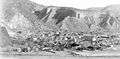 Clifton in 1903
 The Clifton Cliff Jail, sometime before it closed in 1906
 Clifton Mineral Hot Springs Bathhouse, which was built in 1928
References
- 1 2 3 "Geographic Identifiers: 2010 Demographic Profile Data (G001): Clifton town, Arizona". U.S. Census Bureau, American Factfinder. Retrieved November 9, 2016.
- 1 2 "Annual Estimates of the Resident Population for Incorporated Places: April 1, 2010 to July 1, 2015". Retrieved July 2, 2016.
- ↑ "Find a County". National Association of Counties. Archived from the original on 2011-05-31. Retrieved 2011-06-07.
- ↑ Clifton-Morenci Community Profile at Arizona Department of Commerce
- ↑ "US Gazetteer files: 2010, 2000, and 1990". United States Census Bureau. 2011-02-12. Retrieved 2011-04-23.
- ↑ CLIFTON, ARIZONA: Monthly Total Precipitation (inches) - (021849)
- ↑ CLIFTON, ARIZONA: Monthly Total Snowfall (Inches)
- ↑ "Climatic Averages for the United States 1971-2000: CLIFTON, AZ" (PDF). National Oceanic and Atmospheric Administration. Retrieved 2013-03-31.
- ↑ United States Census Bureau. "Census of Population and Housing". Archived from the original on May 11, 2015. Retrieved August 23, 2014.
- ↑ "American FactFinder". United States Census Bureau. Archived from the original on 2013-09-11. Retrieved 2008-01-31.
- ↑ "Town of Clifton, Arizona".
- ↑ "Ian McGaughey takes the reins as Clifton town manager".
External links
![]() Media related to Clifton, Arizona at Wikimedia Commons
Media related to Clifton, Arizona at Wikimedia Commons
- Clifton at Western Mining History, includes photo gallery
Municipalities and communities of Greenlee County, Arizona, United States | ||
|---|---|---|
| Towns | 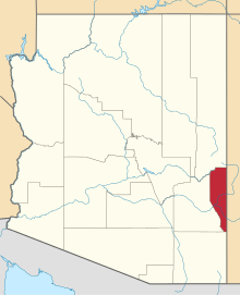 | |
| CDPs | ||
| Unincorporated communities | ||
| Ghost towns | ||