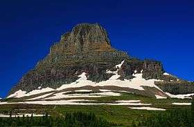
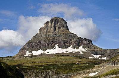
Clements Mountain
| Clements Mountain | |
|---|---|
 Clements Mountain | |
| Highest point | |
| Elevation | 8,760 ft (2,670 m) [1] |
| Prominence | 920 ft (280 m) [2] |
| Coordinates | 48°41′35″N 113°44′25″W / 48.69306°N 113.74028°WCoordinates: 48°41′35″N 113°44′25″W / 48.69306°N 113.74028°W[3] |
| Geography | |
| Location | Glacier County, Montana, Flathead County, Montana, U.S. |
| Parent range | Lewis Range |
| Topo map | USGS Logan Pass, MT |
| Climbing | |
| First ascent | August 13, 1923 (Norman Clyde)[2] |
Clements Mountain (8,760 feet (2,670 m)) is located in the Lewis Range, Glacier National Park in the U.S. state of Montana[1][2] Clements Mountain rises to the west of Logan Pass and above the Hidden Lake Trail which leads to Hidden Lake just west of the continental divide. The peak was named after Walter M. Clements who had worked to set up a treaty between the Blackfeet and the U.S. Government for the purchase of tribal lands east of the continental divide which later became part of the park.[4]
Clements Mountain with Going-to-the-Sun Road at right winding up to Logan Pass Visitor Center
See also
References
- 1 2 "Clements Mountain, Montana" (Map). My Topo (USGS Quads). Retrieved 2010-03-07.
- 1 2 3 "Clements Mountain, Montana". Peakbagger.com. Retrieved 2010-03-07.
- ↑ "Clements Mountain". Geographic Names Information System. United States Geological Survey. Retrieved 2010-09-26.
- ↑ "Clements Mountain". SummitPost.org. Retrieved 2011-05-09.
This article is issued from Wikipedia - version of the 1/22/2016. The text is available under the Creative Commons Attribution/Share Alike but additional terms may apply for the media files.