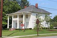
Clarkston, Georgia
| Clarkston, Georgia | |
|---|---|
| City | |
|
Clarkston in 2016 | |
| Motto: “Where Possibilities Grow” | |
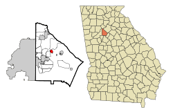 Location in DeKalb County and the state of Georgia | |
| Coordinates: 33°48′37″N 84°14′24″W / 33.81028°N 84.24000°WCoordinates: 33°48′37″N 84°14′24″W / 33.81028°N 84.24000°W | |
| Country | United States |
| State | Georgia |
| County | DeKalb |
| Government | |
| • Mayor | Edward Terry[1] |
| Area | |
| • Total | 1.1 sq mi (2.7 km2) |
| • Land | 1.1 sq mi (2.7 km2) |
| • Water | 0 sq mi (0 km2) |
| Elevation | 1,020 ft (311 m) |
| Population (2010) | |
| • Total | 7,554 |
| • Density | 6,900/sq mi (2,800/km2) |
| • Demonym | Clarkstonian |
| Time zone | Eastern (EST) (UTC-5) |
| • Summer (DST) | EDT (UTC-4) |
| ZIP code | 30021 |
| Area code(s) | 404, 678 |
| FIPS code | 13-16544[2] |
| GNIS feature ID | 0331411[3] |
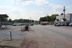
Clarkston is a city in DeKalb County, Georgia, United States. The population was 7,554 as of the 2010 census.[4] The city is home to a campus of Georgia State Universities Perimeter College.
The city is noted for its ethnic diversity, and is often referred to as "the most diverse square mile in America" and "the Ellis Island of the South." In the 1990s refugee resettlement programs identified Clarkston as a good fit for displaced persons of many backgrounds. The rental market was open, residents were moving farther out from the Atlanta urban core, and Clarkston was the last stop on a transit line into the city. By the 2000s the local high school had students from more than 50 countries; a local mosque had 800 worshipers; and by some estimates, half the population was from outside the U.S.
Geography
Clarkston is located at 33°48′37″N 84°14′24″W / 33.81028°N 84.24000°W (33.810304, −84.239877).[5]
According to the United States Census Bureau, the city has a total area of 1.1 square miles (2.8 km2), of which 1.0 square mile (2.6 km2) is land and 0.94% is water.
Clarkston is on the Eastern Continental Divide.
Demographics
| Historical population | |||
|---|---|---|---|
| Census | Pop. | %± | |
| 1880 | 33 | — | |
| 1890 | 271 | 721.2% | |
| 1900 | 362 | 33.6% | |
| 1910 | 349 | −3.6% | |
| 1920 | 501 | 43.6% | |
| 1930 | 606 | 21.0% | |
| 1940 | 921 | 52.0% | |
| 1950 | 1,165 | 26.5% | |
| 1960 | 1,524 | 30.8% | |
| 1970 | 3,127 | 105.2% | |
| 1980 | 4,539 | 45.2% | |
| 1990 | 5,385 | 18.6% | |
| 2000 | 7,231 | 34.3% | |
| 2010 | 7,554 | 4.5% | |
| Est. 2015 | 12,215 | [6] | 61.7% |
As of 2010 Clarkston had a population of 7,554. The racial and ethnic composition of the population was 13.6% white (13.1% non-Hispanic white), 58.4% black or African American (57.9% non-Hispanic black), 0.2% Native American, 4.8% Vietnamese, 16.8% other Asian, 2.1% from some other race and 4.1% from two or more races. 2.8% of the population was Hispanic or Latino of any race.[8]
As of the census[2] of 2000, there were 7,231 people, 2,469 households, and 1,587 families residing in the city. The population density was 6,856.3 people per square mile (2,659.0/km²). There were 2,622 housing units at an average density of 2,486.1 per square mile (964.2/km²). The racial makeup of the city was 19.44% White, 55.66% African American, 0.11% Native American, 12.57% Asian, 0.04% Pacific Islander, 2.56% from other races, and 9.61% from two or more races. Hispanic or Latino of any race were 4.61% of the population.
In 2000, Clarkston foreign residents included African (4%), Arab (1%), West Indian (1%), Asian Indian (1%), Other Hispanic or Latino (1%), and Central American (1%) immigrants.[9]
There were 2,469 households out of which 38.9% had children under the age of 18 living with them, 34.2% were married couples living together, 21.4% had a female householder with no husband present, and 35.7% were non-families. 22.8% of all households were made up of individuals and 2.5% had someone living alone who was 65 years of age or older. The average household size was 2.92 and the average family size was 3.54.
In the city the population was spread out with 30.0% under the age of 18, 12.9% from 18 to 24, 40.0% from 25 to 44, 13.4% from 45 to 64, and 3.7% who were 65 years of age or older. The median age was 28 years. For every 100 females there were 103.7 males. For every 100 females age 18 and over, there were 99.3 males.
The median income for a household in the city was $37,436, and the median income for a family was $38,056. Males had a median income of $27,604 versus $25,000 for females. The per capita income for the city was $14,304. About 19.5% of families and 19.3% of the population were below the poverty line, including 21.0% of those under age 18 and 6.7% of those age 65 or over.
Education
DeKalb County School System operates Clarkston's public schools.
- Indian Creek Elementary School
- Jolly Elementary School
- Freedom Middle School
- Clarkston High School
All the schools are located outside of the city limits of Clarkston.
Atlanta Area School for the Deaf is a State funded school in Clarkston.
Public libraries
DeKalb County Public Library operates the Clarkston Branch.[10]
References
- ↑ "Official site – City of Clarkston, GA". Retrieved January 1, 2015.
- 1 2 "American FactFinder". United States Census Bureau. Archived from the original on September 11, 2013. Retrieved 2008-01-31.
- ↑ "US Board on Geographic Names". United States Geological Survey. 2007-10-25. Retrieved 2008-01-31.
- ↑ "Race, Hispanic or Latino, Age, and Housing Occupancy: 2010 Census Redistricting Data (Public Law 94-171) Summary File (QT-PL), Clarkston city, Georgia". U.S. Census Bureau, American FactFinder 2. Archived from the original on September 11, 2013. Retrieved October 28, 2011.
- ↑ "US Gazetteer files: 2010, 2000, and 1990". United States Census Bureau. 2011-02-12. Retrieved 2011-04-23.
- ↑ "Annual Estimates of the Resident Population for Incorporated Places: April 1, 2010 to July 1, 2015". Retrieved July 2, 2016.
- ↑ "Census of Population and Housing". Census.gov. Archived from the original on May 11, 2015. Retrieved June 4, 2015.
- ↑ 2010 general profile of population and housing characteristics for Clarkston from the US Census]
- ↑ "Clarkston, GA, Ancestry & Family History". Epodunk.com. Retrieved 2015-11-11.
- ↑ "Library Locations & Hours." DeKalb County Public Library. Retrieved on February 24, 2010.
External links
| Wikimedia Commons has media related to Clarkston, Georgia. |
Municipalities and communities of DeKalb County, Georgia, United States | ||
|---|---|---|
| Cities | 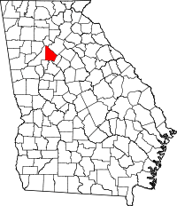 | |
| CDPs | ||
| Neighborhoods and unincorporated communities | ||
| Ghost town | ||
| Footnotes | ‡This populated place also has portions in an adjacent county or counties | |