Clarke County, Iowa
| Clarke County, Iowa | |
|---|---|
|
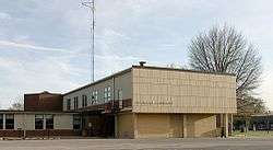
Clarke County Courthouse in Osceola | |
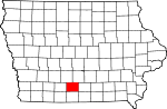 Location in the U.S. state of Iowa | |
 Iowa's location in the U.S. | |
| Founded | 1846 |
| Named for | James Clarke |
| Seat | Osceola |
| Largest city | Osceola |
| Area | |
| • Total | 432 sq mi (1,119 km2) |
| • Land | 431 sq mi (1,116 km2) |
| • Water | 0.6 sq mi (2 km2), 0.1% |
| Population | |
| • (2010) | 9,286 |
| • Density | 22/sq mi (8/km²) |
| Congressional district | 2nd |
| Time zone | Central: UTC-6/-5 |
| Website |
www |
Clarke County is a county located in the U.S. state of Iowa. As of the 2010 census, the population was 9,286.[1] The county seat is Osceola.[2] The county was formed on January 13, 1846. It was named for James Clarke, a Governor of the Iowa Territory.[3]
Geography
According to the U.S. Census Bureau, the county has a total area of 432 square miles (1,120 km2), of which 431 square miles (1,120 km2) is land and 0.6 square miles (1.6 km2) (0.1%) is water.[4]
Major highways
Adjacent counties
- Madison County (northwest)
- Warren County (northeast)
- Lucas County (east)
- Decatur County (south)
- Union County (west)
Demographics
| Historical population | |||
|---|---|---|---|
| Census | Pop. | %± | |
| 1850 | 79 | — | |
| 1860 | 5,427 | 6,769.6% | |
| 1870 | 8,735 | 61.0% | |
| 1880 | 11,513 | 31.8% | |
| 1890 | 11,332 | −1.6% | |
| 1900 | 12,440 | 9.8% | |
| 1910 | 10,736 | −13.7% | |
| 1920 | 10,506 | −2.1% | |
| 1930 | 10,384 | −1.2% | |
| 1940 | 10,233 | −1.5% | |
| 1950 | 9,369 | −8.4% | |
| 1960 | 8,222 | −12.2% | |
| 1970 | 7,581 | −7.8% | |
| 1980 | 8,612 | 13.6% | |
| 1990 | 8,287 | −3.8% | |
| 2000 | 9,133 | 10.2% | |
| 2010 | 9,286 | 1.7% | |
| Est. 2015 | 9,259 | [5] | −0.3% |
| U.S. Decennial Census[6] 2012 Estimate[7] | |||
2010 census
The 2010 census recorded a population of 9,286 in the county, with a population density of 21.545/sq mi (8.319/km2). There were 4,086 housing units, of which 3,701 were occupied.[8]
2000 census
As of the census[9] of 2000, there were 9,133 people, 3,584 households, and 2,498 families residing in the county. The population density was 21 people per square mile (8/km²). There were 3,934 housing units at an average density of 9 per square mile (4/km²). The racial makeup of the county was 96.64% White, 0.11% Black or African American, 0.33% Native American, 0.35% Asian, 0.03% Pacific Islander, 1.96% from other races, and 0.58% from two or more races. 4.04% of the population were Hispanic or Latino of any race.
There were 3,584 households out of which 32.10% had children under the age of 18 living with them, 57.80% were married couples living together, 8.30% had a female householder with no husband present, and 30.30% were non-families. 25.90% of all households were made up of individuals and 13.30% had someone living alone who was 65 years of age or older. The average household size was 2.50 and the average family size was 3.01.
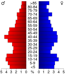
In the county the population was spread out with 26.30% under the age of 18, 7.60% from 18 to 24, 26.50% from 25 to 44, 22.50% from 45 to 64, and 17.10% who were 65 years of age or older. The median age was 39 years. For every 100 females there were 97.00 males. For every 100 females age 18 and over, there were 94.00 males.
The median income for a household in the county was $34,474, and the median income for a family was $42,171. Males had a median income of $29,648 versus $20,522 for females. The per capita income for the county was $16,409. About 6.20% of families and 8.50% of the population were below the poverty line, including 12.10% of those under age 18 and 7.70% of those age 65 or over.
Communities
Cities
Townships
Population ranking
The population ranking of the following table is based on the 2010 census of Clarke County.[10]
† county seat
| Rank | City/Town/etc. | Municipal type | Population (2010 Census)
|
|---|---|---|---|
| 1 | † Osceola | City | 4,929 |
| 2 | Murray | City | 756 |
| 3 | Woodburn | City | 202 |
| 4 | Weldon (mostly in Decatur County) | City | 125 |
See also
References
- ↑ "State & County QuickFacts". United States Census Bureau. Retrieved July 14, 2014.
- ↑ "Find a County". National Association of Counties. Archived from the original on 2011-05-31. Retrieved 2011-06-07.
- ↑ Clarke County
- ↑ "US Gazetteer files: 2010, 2000, and 1990". United States Census Bureau. 2011-02-12. Retrieved 2011-04-23.
- ↑ "County Totals Dataset: Population, Population Change and Estimated Components of Population Change: April 1, 2010 to July 1, 2015". Retrieved July 2, 2016.
- ↑ "U.S. Decennial Census". Census.gov. Archived from the original on May 11, 2015. Retrieved August 1, 2013.
- ↑ "Annual Estimates of the Resident Population: April 1, 2010 to July 1, 2012". Census.gov. Retrieved August 1, 2013.
- ↑ "Population and Housing Occupancy Status: 2010 - State -- County". United States Census Bureau American FactFinder. Retrieved March 9, 2011.
- ↑ "American FactFinder". United States Census Bureau. Archived from the original on 2013-09-11. Retrieved 2008-01-31.
- ↑ "Archived copy". Archived from the original on 2013-12-21. Retrieved 2013-02-10.
| Wikimedia Commons has media related to Clarke County, Iowa. |
 |
Madison County | Warren County | | |
| Union County | |
Lucas County | ||
| ||||
| | ||||
| Decatur County |
Municipalities and communities of Clarke County, Iowa, United States | ||
|---|---|---|
| Cities | ||
| Townships | ||

Coordinates: 41°01′22″N 93°47′11″W / 41.02278°N 93.78639°W