Clairmont, Alberta
| Clairmont | |
|---|---|
| Hamlet | |
 Location of Clairmont in Alberta | |
| Coordinates: 55°15′41″N 118°47′37″W / 55.2614°N 118.7936°W | |
| Country |
|
| Province |
|
| Census division | No. 19 |
| Municipal district | County of Grande Prairie No. 1 |
| Government | |
| • Type | Unincorporated |
| • Reeve | Leanne Beaupre |
| • Governing body |
County of Grande Prairie No. 1 Council
|
| Population (2006)[1] | |
| • Total | 2,174 |
| Time zone | MST (UTC-7) |
Clairmont is a hamlet in northern Alberta, Canada within the County of Grande Prairie No. 1.[2] Previously an incorporated municipality, Clairmont dissolved from village status on January 1, 1946 to become part of the Municipal District of Bear Lake No. 740.[3]
Clairmont is located in the Peace Country, along Highway 2, approximately 10 km (6.2 mi) north of Grande Prairie and 9 km (5.6 mi) south of Sexsmith.
Clairmont lies at an elevation of 685 m (2,247 ft), on the western shore of Clairmont Lake.[4] Initially the area was commonly known as Twin Lakes.[5] The first use of the name “Clairmont” was in 1907 by the earliest surveyor of the township boundaries, JB Saint Cyr.[6]
History
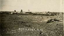
Development of the townsite really got started once it was surveyed and after the arrival of the Edmonton, Dunvegan & British Columbia Railway in 1916. By the end of 1916, the townsite had a railway station, two or three grain elevators, an agent’s house, the Buffalo Lakes Lumber Yard, Clairmont Hotel, a Union Bank, a butcher shop, several stores, a Baptist church, and a handful of residences.[7] On September 10, 1915 the Clairmont Lake School District was opened.[5] A post office was established in 1916.[8] In 1922, a large fire consumed many Clairmont businesses, while a train station was built in 1923.
Clairmont was incorporated as a village in 1917, but renounced the village status in 1946 after a downturn in economy caused by the great depression. It eventually became the location of the County of Grande Prairie No. 1's municipal office.
A new school was built with municipal funding in 2007 and opened in 2008.
Demographics
The population of Clairmont according to the County of Grande Prairie No. 1's 2006 municipal census is 2,174.[1]
Industry Canada shows that Clairmont's greater rural area had a total population of 1,975 living in 712 dwellings in 2001. With a land area of 247.83 km2 (95.69 sq mi), its greater rural area has a population density of 8.0/km2 (21/sq mi).[9]
See also
References
- 1 2 County of Grande Prairie No. 1. "Economic Profile" (PDF). Retrieved January 10, 2010.
- ↑ "Specialized and Rural Municipalities and Their Communities" (PDF). Alberta Municipal Affairs. April 1, 2010. Retrieved June 6, 2010.
- ↑ "Table 6a: Population by census divisions and subdivisions showing reorganization of rural areas, 1931-1946". Census of the Prairie Provinces, 1946. Volume I: Population. Ottawa: Dominion Bureau of Statistics. 1949. p. 429.
- ↑ Discover the Peace Country. "Clairmont". Retrieved 2007-06-21.
- 1 2 South Peace Regional Archives (September 1, 2015). "100th Anniversary of Clairmont". Telling our Stories. 6 (4): 5.
- ↑ "Township Notes/Field Plans". SpinII. Alberta Registries and Land Titles. Retrieved 5 October 2015.
- ↑ Sheehan, Beth (1992). Turn Back the Pages Clairmont 1908-1992. South Peace Regional Archives: Beth Sheehan. p. 21.
- ↑ "Post Offices and Postmasters". Library and Archives Canada. Government of Canada. Retrieved 5 October 2015.
- ↑ Industry Canada/Web Archive (2006-11-04). "Clairmont - Community demographics (2001 census)". Retrieved 2010-02-07.
 |
Hythe | Sexsmith | Girouxville | |
| Beaverlodge | |
Teepee Creek Bezanson Debolt | ||
| ||||
| | ||||
| Wembley | Grande Prairie | Valleyview |
Coordinates: 55°15′41″N 118°47′37″W / 55.26139°N 118.79361°W