Churachandpur district
| Churachandpur District <span class="nickname" lang="Paite[1]">Lamka[1] | |
|---|---|
| District | |
|
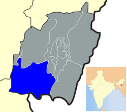
Location of Churachandpur district in Manipur | |
| Coordinates: 24°20′N 93°41′E / 24.333°N 93.683°ECoordinates: 24°20′N 93°41′E / 24.333°N 93.683°E | |
| Country |
|
| State | Manipur |
| District | Churachandpur |
| Headquarters | Churachandpur |
| Elevation | 914.4 m (3,000.0 ft) |
| Population (2011)[2] | |
| • Total | 271,274 |
| • Density | 59/km2 (150/sq mi) |
| Time zone | IST (UTC+5:30) |
| PIN | 795128 |
| Telephone code | 03874 |
| Vehicle registration | MN |
| Sex ratio | 969 females per 1000 males[2] ♂/♀ |
| Website |
ccpurdistrict |
Churachandpur (Pron:/'tʃʊraːˌtʃaːnɗpʊr/) is a district located in the south-western corner of the Indian state of Manipur which covers an area of 4,750 kilometres (2,950 mi).
Economy
In 2006 the Ministry of Panchayati Raj named Churachandpur one of the country's most impoverished districts (out of a total of 640).[3] It is one of the three districts in Manipur currently receiving funds from the Backward Regions Grant Fund Programme (BRGF).[3]
Demographics
As of the 2011 census, Churachandpur district had a population of 271,274,[4] roughly equal to that of Barbados.[5] This gives it a ranking of 575th in India (out of a total of 640 districts).[4] The district has a population density of 59 inhabitants per square kilometre (150/sq mi).[4] Its population growth rate over the decade 2001–2011 was 19.03%.[4] Churachandpur has a sex ratio of 969 females for every 1000 males,[4] and a literacy rate of 84.29%.[4] The area also includes fewer than 3,000 speakers of the Sino-Tibetan Aimol language, which is written using Latin script.[6]
| Area: | 4,570 square kilometres (1,760 sq mi) | Rank 1/9 |
| Literacy Rate (2001) | 84.29%[2] | Rank 2/9 |
| Literacy by Gender | Male 88.34%[2] | Female 80.13%[2] |
| Population (2011 Census) | 271,274[2] | Rank 5/9 |
| Population % to state population | 9.97%[2] | (2011 Census) |
| Sex ratio | 969 (2011 Census)[2] | 993 (2001 Census), 1004 (1961 Census) |
| Temperature | 41oC Maximum | 0oC Minimum |
| Humidity | 89% Maximum | 20% Minimum |
| Longitude | 93.15oE | 94.0oE |
| Latitude | 24.0oN | 24.3oN |
| Altitude | 914.4 metres | (District Hqrs.) |
| Population Density | 50 (2001 Census) | Rank 6/9 |
| Telephone Code | + 3874 | |
| Postal Code | Churachandpur 795128 |
Languages
Various Northern languages are spoken in Churachandpur district, including the following.
Khousabung
Khousabung is a village in Samulamlan tehsil, Churachandpur district of Manipur, India. It is located 54 kilometers from the state capital Imphal. Its inhabitants are mostly Gangte. More than 1,000 people live in the village. The economy of Khousabung is mainly agricultural, with locals planting and selling pineapple (locally called lengthei). Every year about 70 to 100 tons are exported from Khousabung.
References
- 1 2 Neihsial, Dr. Tualchin (1996) This is Lamka: A Historical Account of the Fastest Growing Town of Manipur Hills, Churachandpur, India: Zogam Book Centre & Library
- 1 2 3 4 5 6 7 8 "Census of India: Provisional Population Totals and Data Products – Census 2011: Manipur". "Office of the Registrar General and Census Commissioner, Ministry of Home Affairs, Government of India". 2011. Retrieved 1 June 2011.
- 1 2 Ministry of Panchayati Raj (8 September 2009). "A Note on the Backward Regions Grant Fund Programme" (PDF). National Institute of Plural Development. Archived from the original (PDF) on 5 April 2012. Retrieved 27 September 2011.
- 1 2 3 4 5 6 "District Census 2011". Census2011.co.in. 2011. Retrieved 30 September 2011.
- ↑ US Directorate of Intelligence. "Country Comparison:Population". Retrieved 1 October 2011.
Barbados 286,705 July 2011 est.
- ↑ M. Paul Lewis, ed. (2009). "Aimol: A language of India". Ethnologue: Languages of the World (16th ed.). Dallas, Texas: SIL International. Retrieved 28 September 2011.
- The history and Land-holding behind Manipur South District with Special Reference to the Haokip Reserved Land- 1907: By T.S Letkhosei Haokip (Manipur University).
- Census of India 2001: Manipur Series 14 (Provisional Population Totals), Imphal: Directorate of Census Operations, Manipur.
- Chinkhopau (1995) Churachandpur District, Churachandpur: Published by Author.
- District Statistical Handbook – Churachandpur: District Statistical Officer.
- Gangte, Thangzam (undated) Churachandpur Chanchin (An Account of Churachandpur)
- Ginsum, H (undated) Lamka Vangkhua (Lamka Town).
- Kamkhenthang, Dr. H (1995) "Lamka Town vis-a-vis Churachandpur", Shan (daily), 21 December.
- Kamkhenthang (1998) "Lamka (Churachandpur)" in B.D. Ray, A.K. Neog & H.K. Mazhari (eds.) Urban Development in North-East India : Potentiality and Problems, New Delhi: Vedams Books.
- Manipur State Archives, Imphal: Manipur State Durbar 1907–1947 – Papers related to the Court of the President of Manipur State Durbar, Hill Misc. Case No. 28 of 1945–46, Phungkhothang Chief of Hiangtam Lamka; also Misc Case No. 504 of 1934 Phungkhothang Chief of Hiangtam Lamka.
- Neihsial, Dr. Tualchin (1996) This is Lamka: A Historical Account of the Fastest Growing Town of Manipur Hills, Churachandpur, India: Zogam Book Centre & Library.
- Nengzachin (1974) "North East India General Mission Tanchin" in Jubilee Thusuah 1974, Churachandpur: Evangelical Convention Church; pp. 1–18.
External links
 |
Cachar district, Assam | Tamenglong district | Bishnupur district Senapati district |
|
| Kolasib district, Mizoram | |
Chandel district | ||
| ||||
| | ||||
| Champhai district, Mizoram | Myanmar |